![]()

Yonaguni Monument
Yonaguni Monument - Yonaguni, Japan
The Yonaguni Monument is a massive submerged rock formation located approximately 100 meters off the southern coast of Yonaguni Island, the westernmost inhabited island of Japan in the Ryukyu chain, at depths ranging from 5 to 30 meters. Discovered in 1986 by local dive operator Kihachiro Aratake while scouting for hammerhead shark habitats, the site features a series of terraced sandstone structures resembling stepped pyramids, broad platforms, and rectilinear formations up to 50 meters long, 20 meters wide, and 25 meters tall, with sharp right angles, flat surfaces, and apparent staircases that evoke ancient architecture.
The monument's enigmatic appearance has sparked intense debate among geologists, archaeologists, and marine scientists since its discovery, primarily centering on whether it represents human-engineered ruins from a prehistoric civilization or a natural geological phenomenon shaped by erosion and tectonic forces. Marine geologist Masaaki Kimura of the University of the Ryukyus, who has conducted over 100 dives at the site, argues it is artificial, proposing it as remnants of a sunken city from the mythical lost continent of Mu, potentially dating to 10,000–12,000 years ago with features like alleged roads, retaining walls, and pillar holes. In contrast, the prevailing scientific consensus, supported by experts such as geologist Robert Schoch of Boston University, attributes the structures to natural processes: the island's sandstone bedrock, fractured along horizontal and vertical bedding planes due to seismic activity in the tectonically active Ryukyu region, has been sculpted by underwater currents, wave action, and differential erosion into geometric patterns common in coastal geology worldwide, with no confirmed tool marks, artifacts, or cultural evidence indicating human modification.
Despite the lack of archaeological consensus, the Yonaguni Monument has become a renowned diving destination, attracting thousands of visitors annually to explore its labyrinthine features and bioluminescent marine life, while ongoing research continues to investigate its formation through geophysical surveys and comparative geological studies. The site's ambiguity underscores broader questions about interpreting underwater landforms in regions prone to natural submersion, such as post-Ice Age sea-level rise, which submerged parts of the Ryukyu shelf around 10,000 years ago.
Overview and Discovery
Physical Description
The Yonaguni Monument consists of a series of massive, terraced rock formations resembling stepped platforms, right-angled walls, and staircases, composed primarily of layered sandstone and mudstone from the Miocene Yaeyama Group. These features exhibit sharp, geometric edges formed along natural horizontal and vertical bedding planes and joints in the bedrock, with some surfaces appearing smoothed by marine erosion. The overall site spans an area of approximately 300 meters by 150 meters, covering about 45,000 square meters at depths ranging from 5 to 30 meters.
The central structure, often described as a pyramid-like monolith, measures roughly 50 meters long, 20 meters wide, and 25 meters high, rising prominently from the seafloor with broad, flat terraces and vertical faces. Notable elements include a main terrace featuring precise 90-degree corners, deep vertical shafts, and triangular protrusions, alongside interconnected platforms that suggest pathways or enclosures. Surrounding the primary formation are smaller outcrops, such as the Turtle formation—a sharply carved rock resembling a turtle viewed from above—and other irregular shapes interpreted by some observers as animal-like figures.
Detailed mapping of the monument began in the late 1980s and 1990s through scuba dives, sonar scans, and underwater photography, which documented the site's extensive layout and confirmed its position within a broader field of fractured sandstone ridges. These surveys highlighted the monument's scale and the way its blocks, some weighing hundreds of tons, align in patterns that mimic architectural elements while reflecting the local geology's tendency to fracture orthogonally.
Historical Discovery
 The Yonaguni Monument was initially sighted in 1986 by Kihachiro Aratake, a local dive tour operator and director of the Yonaguni-Cho Tourism Association, while he was scouting dive sites off the southern coast of Yonaguni Island to observe hammerhead sharks. Aratake noticed distinctive seabed formations resembling terraces and steps during this dive, which prompted further exploration of the area.
The discovery was first publicized in 1987 through Japanese media outlets, drawing attention to the unusual underwater structures without initial assertions of artificial construction. Early subsequent dives by local operators confirmed the presence of these geometric rock features, but they were primarily viewed as natural anomalies at the time, with no formal scientific claims of human origin. Local fishermen had long been aware of the general underwater topography near Yonaguni Island due to their activities in the region, yet there are no documented records of the specific formations prior to Aratake's sighting in the 1980s.
Scientific interest emerged in the mid-1990s, with geologist Masaaki Kimura of the University of the Ryukyus leading initial academic investigations starting in 1995; Kimura proposed that the structures were man-made remnants of an ancient civilization, sparking broader debate. During the 1990s, expeditions organized by Kimura and his team produced the first comprehensive photographic and video documentation of the site, including detailed surveys of its layout and features, which helped establish it as a subject of geological and archaeological inquiry.
Location and Geological Context
Geographical Position
The Yonaguni Monument is situated approximately 100 to 150 meters offshore from the southern coast of Yonaguni Island, in Okinawa Prefecture, Japan, at coordinates roughly 24°26′N 123°01′E. This positions it adjacent to Arakawabana Cape, a prominent headland on the island's rugged shoreline.
Yonaguni Island marks the southernmost extent of the Ryukyu Islands archipelago, lying about 110 kilometers east of Taiwan in the East China Sea. The region experiences strong ocean currents and is prone to seasonal typhoons, particularly from June to October, which can limit access to the site by complicating boat navigation and diving operations.
The monument lies submerged at depths ranging from 5 to 30 meters, with shallower sections near the surface and steeper drops toward the deeper ocean floor. Water visibility typically spans 20 to 40 meters in favorable conditions, though it can diminish during monsoon-influenced periods due to sediment and wave action. Surrounding the site are shallower coral reefs that give way to abrupt drop-offs leading to deeper trenches, contributing to the area's dynamic marine environment.
Rock Formation and Composition
The Yonaguni Monument consists primarily of medium- to fine-grained sandstone and mudstone belonging to the Lower Miocene Yaeyama Group, a sequence of sedimentary rocks formed through the deposition of sands and muds transported from the Eurasian continent. These layers exhibit horizontal bedding planes characteristic of sedimentary deposition in ancient shallow-marine and nonmarine environments, with quartz-rich sandstones interbedded with darker mudstones. The overall formation of the Yaeyama Group occurred approximately 20 million years ago during the Miocene epoch, as part of broader tectonic and sedimentary processes in the Ryukyu arc region.
The monument's submergence is attributed to post-glacial sea-level rise following the end of the last Ice Age, when global sea levels increased by over 100 meters around 12,000 years ago, inundating coastal landforms that were previously exposed. This event placed the structure at its current depth of about 25 meters below sea level, with stratigraphic analyses indicating that the exposed rock surfaces have been underwater for roughly 10,000 to 12,000 years. Prior to submergence, the formations were subject to subaerial weathering, but their current configuration reflects ongoing marine influences.
The distinctive angular features of the monument, including stepped terraces and sharp edges, result from natural geological processes rather than human intervention. Tectonic activity along the nearby Ryukyu Trench, part of the subduction zone where the Philippine Sea Plate converges with the Eurasian Plate, has induced fracturing and faulting in the bedrock, creating vertical joints that intersect the horizontal bedding planes. Additionally, erosion by powerful ocean currents, waves, and seismic shaking has accentuated these fractures, causing layers to separate cleanly along bedding planes and form the observed geometric patterns without evidence of tool marks or artificial alteration.
Geological examinations, including on-site dives and sample analyses, support this natural origin. Boston University geologist Robert Schoch, who has conducted multiple investigations at the site, identified the sandstones' inherent jointing and bedding as key factors in the formation's shape, noting that "the layers easily separate" along natural planes, consistent with sedimentary rock behavior under tectonic stress and erosion. Japanese geological surveys of the Yaeyama Group in the region, including studies of similar outcrops on Yonaguni Island, confirm the absence of anthropogenic modifications, aligning with broader assessments that attribute the monument's morphology to endogenous geological forces.
Interpretations of Origin
Evidence for Natural Formation
 The mainstream geological consensus attributes the Yonaguni Monument to natural processes acting on Miocene-era sandstone formations, rather than human intervention. Geologist Robert Schoch of Boston University, who has conducted multiple dives at the site, describes the structures as resulting from classic sandstone stratigraphy, where the rock naturally fractures along horizontal bedding planes and vertical fault lines due to tectonic stresses. This jointing produces the observed right angles, flat surfaces, and stepped terraces without requiring artificial carving.
Supporting evidence includes the presence of marine fossils and sedimentary layers within the sandstone, confirming its origin as a natural deposit from ancient shallow marine environments dating back approximately 20 million years. The "steps" and platforms exhibit a random distribution aligned with these natural fracture patterns, lacking the uniform block-cutting or precise astronomical alignments typical of human-made monuments. Seismic activity in the tectonically active Ryukyu region has further contributed to the fracturing and exposure of these features over millennia, with differential erosion by ocean currents accentuating the blocky appearance as softer layers wear away faster than harder ones.
Apparent "roads" and "walls" are explained by channels formed through current-induced erosion and shifted platforms from faulting, rather than constructed pathways. No artifacts, tools, or cultural remains from the Jomon period or earlier have been recovered at the site, undermining claims of human origin and reinforcing the interpretation as a product of prolonged geological and erosional processes. Comparative studies highlight similarities to other natural sites, such as the geometric basalt columns of Northern Ireland's Giant's Causeway, where fracturing creates illusory rectilinear patterns.
Arguments for Artificial Construction
Marine geologist Masaaki Kimura of the University of the Ryukyus has been the primary proponent of the artificial origin theory for the Yonaguni Monument, asserting that it represents remnants of a submerged ancient city from the end of the last Ice Age. Kimura, who has conducted over 100 dives at the site, describes the formation as a complex of man-made structures including stepped pyramids, roads, castles, and water channels, suggesting it was part of the lost continent of Mu, a mythical Pacific civilization. He proposes that the site, originally above sea level, was submerged due to post-glacial sea-level rise approximately 10,000 to 12,000 years ago, potentially serving as a ceremonial center or port along ancient Asian migration routes, though he has also cited evidence like stalactites suggesting an age of at least 5,000 years.
Kimura's key evidence includes the monument's precise right angles, flat surfaces, and symmetrical features, which he interprets as signs of quarrying and intentional construction rather than natural erosion. He points to alleged staircases, plazas, and triangular formations resembling stepped pyramids, as well as what he claims are quarry marks, stone tools, and a carved stone tablet with ancient script found nearby. Additionally, Kimura argues that the site's proximity to the Ryukyu Islands positions it along potential prehistoric seafaring paths from mainland Asia, supporting human habitation and engineering capabilities during the Pleistocene.
Geologist Robert Schoch of Boston University offers a more tempered view, suggesting that while the monument is predominantly a natural sandstone formation shaped by tectonic and erosional processes, certain aspects may indicate ancient human modifications. After multiple dives, Schoch acknowledges features like parallel bedding planes and jointing that could facilitate human enhancement, such as carving steps or platforms, potentially dating to 8,000–10,000 BCE, but he emphasizes the absence of definitive artifacts to confirm this.
These artificial construction arguments face significant scrutiny, primarily due to the lack of peer-reviewed publications supporting Kimura's interpretations and the failure to recover unequivocal archaeological artifacts like tools or human remains. Critics note that the cited features, such as angles and steps, can be explained by natural geological fracturing in the area's mudstone and sandstone layers, and the ties to Atlantis-like myths, including Mu, rely on speculative connections without corroborating evidence from other sites. While proponents like Kimura dismiss natural formation theories, the absence of datable cultural materials undermines claims of an ancient purpose-built complex.
Tourism and Cultural Impact
Access for Divers and Visitors
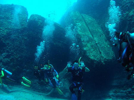
Access to the Yonaguni Monument is primarily via boat dives departing from ports on Yonaguni Island, such as Irizaki Harbour in Kubura on the island's western tip, with trips lasting about 20 minutes to the site. Divers typically engage in drift dives due to the site's exposure to ocean currents, starting from the southeast side of the island and descending to explore the formation's terraces and features. The diving season varies; June to October offers warmer water temperatures of 27-29°C, but this coincides with the typhoon season (June to November), which can disrupt access with rough seas. November to May is preferred for hammerhead shark sightings and better visibility, though winter winds may make monument access more challenging.
Diving the monument requires advanced open-water certification or equivalent experience, as strong currents—often described as powerful and constant—can reach levels challenging for beginners, necessitating skills in drift diving and buoyancy control. Local tour operators, including Yonaguni Diving Service and Sou-Wes Yonaguni, provide guided excursions with English-speaking instructors, typically offering 2-3 dives per day lasting 30-35 minutes each, including safety stops. Costs for a full day of diving, including gear rental, tanks, weights, and insurance, range from 17,000 to 20,000 JPY, though packages may vary with additional services like lunch or transport.
Safety protocols emphasize depths limited to 25-30 meters to stay within recreational limits, with a strict no-touch policy enforced to prevent damage to the fragile sandstone formations and marine environment. Occasional sightings of hammerhead sharks occur, particularly during drift dives from November to May, but these are generally calm and pose low risk to properly trained divers following guidelines. The site attracts dedicated divers annually, contributing to the island's niche tourism, with renewed interest in guided tours following COVID-19 recovery. Yonaguni Island offers accommodations tailored to visitors, including guesthouses and minshuku operated by dive centers like Pension Di-Pa and Yonaguni Kanko Hotel, providing convenient access to facilities, meals, and airport transfers.
Pseudoarchaeological Influence and Debates
The Yonaguni Monument has significantly influenced pseudoarchaeological narratives, often depicted in media as evidence of a submerged ancient civilization akin to Atlantis. Documentaries such as the BBC's 2022 production "The truth behind Japan's mysterious 'Atlantis'" examine the site's stepped formations and debate their origins, amplifying speculation about lost Pacific cultures. Similarly, National Geographic's 2007 article portrayed the structure as an enigmatic underwater pyramid, captivating global audiences with suggestions of human engineering predating known history. Books promoting these ideas, including Graham Hancock's Underworld: The Mysterious Origins of Civilization (2002), argue that Yonaguni represents remnants of Ice Age societies flooded by rising seas, drawing on dives and imagery to support claims of artificial design.
This media portrayal has permeated popular culture, inspiring tourism campaigns that market the site as "Japan's Atlantis" to attract divers and explorers. Local promotions emphasize its mysterious allure, boosting visitor interest while blending factual geology with speculative lore. In alternative history circles, the monument fuels discussions of advanced prehistoric societies, with international proponents like Hancock contrasting Japanese geological consensus on its natural formation. These debates highlight cultural divides, where domestic views prioritize tectonic processes and global perspectives entertain anthropogenic possibilities, sustaining the site's role in rethinking human timelines.
Preservation challenges have emerged amid rising tourism, as unregulated diving risks physical damage to the fragile sandstone features. Without designated protection from Japanese authorities, the site remains vulnerable to human impact, prompting calls among conservationists for its recognition as a natural heritage landmark to mitigate erosion and overcrowding. In the 2020s, social media has reignited interest through viral videos and discussions, though no major scientific expeditions have occurred since the early 2010s. As of 2025, analyses continue to link the monument's submersion to post-Ice Age sea-level rise around 10,000–12,000 years ago.
Content generated by AI. Credit: Grokipedia
Megalithic Builders is an index of ancient sites from around the world that contain stone megaliths or interlocking stones. Genus Dental Sacramento