![]()

Hattusa Complex
Hattusa Complex - Anatolia, Turkey
Hattusa, also known as Hattusha, was the capital of the Hittite Empire, a major Bronze Age power in Anatolia, serving in that role from the late 17th century BCE until its abandonment in the early 12th century BCE. Located near the modern town of Boğazkale in Çorum Province, central Turkey, the ancient city spanned an area enclosed by approximately 8 kilometers of monumental fortifications, divided into a Lower City and an expanded Upper City added during its peak. Originally settled in the late 3rd millennium BCE, Hattusa was rebuilt and fortified by King Hattusili I around 1650–1620 BCE, transforming it into a defensible political, religious, and administrative center that influenced regions across Anatolia and northern Syria.
At its height under rulers like Suppiluliuma I (c. 1344–1322 BCE) and Tudhaliya IV (c. 1237–1209 BCE), Hattusa became a sprawling metropolis housing over 30 temples, a royal palace on the acropolis of Büyükkale, and grand gateways such as the Lions’ Gate and Royal Gate, all exemplifying advanced Hittite urban planning and monumental architecture from the 13th century BCE. The city's cultural and religious prominence is evident in its over 30,000 cuneiform tablets—recognized by UNESCO as part of the Memory of the World Register in 2001—and the nearby Yazılıkaya rock sanctuary featuring reliefs of deities and King Tudhaliya IV. Designated a UNESCO World Heritage Site in 1986, Hattusa stands as a testament to the Hittite civilization's artistic achievements, architectural ensembles, and role in shaping ancient Near Eastern history, with excavations revealing evidence of its sudden decline around 1200 BCE amid fires, disruptions from migrations and invasions including those associated with the Sea Peoples, famine, and internal strife during the reign of the last known king, Suppiluliuma II.
Geography and Layout
Location and Topography
Hattusa is situated in the Boğazkale District of Çorum Province, in north-central Turkey, at coordinates approximately 40°01′N 34°37′E. The ancient city lies on a prominent ridge that overlooks the broad valley of the Kızılırmak River, the longest river entirely within modern Turkey's borders, which provided a vital corridor for trade and agriculture in the region. This strategic positioning in the Northern Central Anatolian Mountain Region placed Hattusa at the southern edge of the Budaközü Plain, integrating it into a landscape of rolling highlands and riverine lowlands.
The site's topography features a rocky plateau elevated to around 1000 meters above sea level, spanning a core area of 268.46 hectares as designated by UNESCO. The terrain rises sharply, with slopes ascending approximately 300 meters above the surrounding valley, offering inherent defensive advantages through its steep gradients and elevated vantage. This undulating landscape naturally divides the settlement into an upper town on the higher acropolis and a lower town below, separated by the Kızlarkayası creek that bisects the plateau and facilitated water management. The overall site covers about 1.8 square kilometers at its peak extent, with the rugged volcanic and sedimentary rock formations contributing to the durability of its preserved structures.
Environmentally, Hattusa occupied a semi-arid climate zone typical of central Anatolia, characterized by low annual precipitation and hot, dry summers that necessitated reliance on the Kızılırmak River for irrigation and agricultural sustenance. The river's valley supported fertile alluvial soils suitable for crops like wheat and barley, essential for the city's large population. Archaeological and paleoclimatic evidence indicates that a severe multi-year drought from approximately 1198 to 1196 BCE coincided with the site's abandonment, exacerbating vulnerabilities in this water-stressed environment.
Urban Structure and Fortifications
 Hattusa's urban layout was meticulously planned, reflecting the Hittites' engineering prowess and strategic priorities. The city was divided into distinct zones: the Upper Town, serving as an acropolis primarily dedicated to temples and elite structures; the Lower Town, encompassing administrative buildings and densely populated residential areas; and outer extensions that incorporated additional defensive and utilitarian spaces. This organization accommodated estimates of 10,000 to 50,000 inhabitants at its peak, depending on inclusion of surrounding areas, supported by the surrounding arable land and resource management systems.
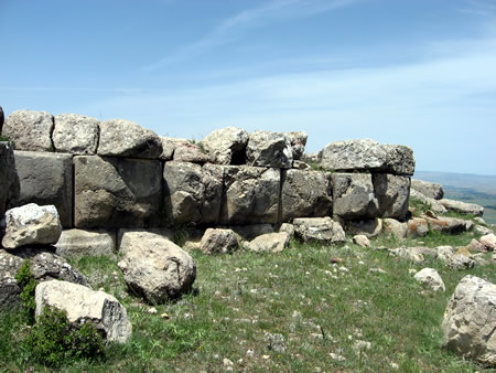
The fortifications of Hattusa formed a formidable defensive network, spanning approximately 6 to 8 kilometers of double-walled circuits that encircled the entire urban area. These walls, constructed primarily during the empire's height in the 14th and 13th centuries BCE, featured over 100 protruding towers spaced at regular intervals to enhance surveillance and artillery positioning, along with multiple postern gates for covert access and evacuation. A notable element was the Yerkapı tunnel, a 70-meter-long subterranean passage integrated into the ramparts, allowing secure movement between inner and outer zones while exploiting the natural terrain for added protection; recent excavations (as of 2024) have revealed painted hieroglyphs within the tunnel, offering new insights into Hittite construction techniques.
Urban planning in Hattusa emphasized functionality and adaptation to the rugged landscape, with grid-like streets organizing the Lower Town's residential and administrative quarters into orderly blocks. Water management was sophisticated, relying on natural springs supplemented by cisterns, channels, and artificial ponds to ensure supply for the population and ceremonial needs. The city's multi-level terracing integrated steep slopes and rocky outcrops, creating habitable platforms that maximized usable space without extensive leveling.
Over time, Hattusa expanded significantly from an initial area of about 0.5 square kilometers in the early Bronze Age to roughly 1.8 square kilometers during the Late Bronze Age empire, incorporating new districts like the Upper Town to accommodate growing administrative and religious demands. This phased growth, driven by imperial consolidation, transformed the settlement into a sprawling capital while maintaining defensive integrity.
Historical Overview
Pre-Hittite Settlement
The earliest evidence of human occupation at the site of Hattusa dates to the Chalcolithic period in the 6th millennium BCE, with settlements emerging around the modern village of Boğazkale, particularly on the Büyükkale plateau and nearby areas such as Büyük Güllücek, Yarıkkaya, and Çamlıbel Tarlası. These early communities likely originated from the Black Sea region and constructed simple rectangular one-room houses at medium altitudes, supported by pottery and stone tools that indicate the beginnings of farming and sedentary life. Archaeological surveys reveal sparse but continuous occupation through the Neolithic and into the Early Bronze Age, with settlement patterns evolving from small hamlets to more structured forms by the late 3rd millennium BCE.
By the 3rd millennium BCE, during the Early Bronze Age, the site saw the development of a Hattian settlement characterized by dense habitation between the Büyükkale and the Lower Town, featuring multi-room houses, metalworking activities, and distinctive pottery. The Hattians, an indigenous Anatolian people, established small fortified settlements on the Büyükkale and surrounding environs, marking the onset of more organized urban precursors. Their culture included local deities and rituals, with the term "Hatti" first appearing in Mesopotamian texts, reflecting regional significance.
In the 19th and 18th centuries BCE, Hattusa—known then as "Hattus"—functioned as an Assyrian trading colony, with merchants from Kanesh (modern Kültepe) establishing a karum (trading post) in the Lower City and northwest areas. This phase introduced Assyrian cuneiform writing, evidenced by clay tablets documenting trade in tin and textiles along routes connecting to Kanesh, approximately 150 km south. The colony integrated with the existing Hattian population, fostering economic growth through craft activities like pottery production and metalworking.
Around 1700 BCE, the settlement was destroyed by fire, as indicated by a thick carbonized layer in archaeological strata across the site, attributed to King Anitta of Kussara (near Kanesh). Anitta's annals, preserved in later Hittite texts, record his conquest and cursing of the site to prevent repopulation, leading to temporary abandonment. This event marked the end of the pre-Hittite phase, though some evidence suggests limited continuity in peripheral areas.
The Hattian cultural legacy profoundly shaped subsequent inhabitants, with their non-Indo-European language—a prefixing, verb-subject-object (VSO) structured tongue—serving as the primary cultic medium and influencing Hittite religious practices. Bilingual Hattian-Hittite texts, such as KUB 2.2, demonstrate syntactic borrowings, including genitive constructions and word order adaptations in rituals, alongside approximately 30 loanwords like ḫalmaššuit- ("throne"). Hattian deities and motifs permeated Hittite mythology and festivals, such as the purulli- spring rite, with rituals involving music, incantations, and narratives preserved in cultic performances. This Hattian substrate provided foundational non-Indo-European elements in Anatolian religious and linguistic traditions.
Rise as Hittite Capital
 Hattusili I (c. 1650–1620 BC), originally ruling from the city of Kussara, refounded Hattusa as the Hittite capital after its earlier destruction by Anitta, who had razed the settlement and invoked a curse against its resettlement. Despite the curse documented in Anitta's inscription, Hattusili rebuilt the city on its strategic location in central Anatolia, leveraging its natural defenses and resources to establish a stable base for Hittite expansion. This refounding marked the transition from localized rule to a more unified Hittite polity, with Hattusa serving as the political and religious center.
Under subsequent rulers, particularly Mursili I (c. 1620–1590 BC), the city experienced significant early expansions through military conquests that bolstered its growth. Mursili's campaigns extended Hittite influence southward, culminating in the sack of Babylon around 1595 BC, which disrupted the Old Babylonian dynasty and brought substantial booty to Hattusa, funding further development including the construction of new temples. These conquests not only secured borders against regional rivals but also integrated conquered territories, enhancing Hattusa's role as an administrative hub during the Old Hittite Kingdom (c. 1650–1400 BC).
The period was characterized by a shift toward centralized rule, with the king exercising direct authority over governance, military, and religious affairs from Hattusa. This centralization facilitated internal stability amid occasional border conflicts with neighboring powers like the Hurrians and Assyrians. Concurrently, Hittite administration incorporated Hattian elements, particularly in religious practices, where indigenous Hattian deities and rituals were syncretized into the Hittite pantheon, reflecting cultural adaptation in the core region. This integration helped legitimize Hittite dominance over the pre-existing Hattian population, contributing to the kingdom's cohesion during its foundational phase.
Peak and Decline of the Empire
The Hittite Empire reached its zenith during the New Kingdom period, approximately 1400–1200 BCE, marked by significant territorial expansions and military achievements under influential rulers such as Suppiluliuma I and Muwatalli II. Suppiluliuma I, who reigned from around 1344–1322 BCE, revitalized Hittite power through campaigns that consolidated control over northern Syria, including the installation of his sons as kings in Aleppo and Carchemish, thereby extending the empire's influence deep into Levantine territories. His successor, Muwatalli II, ruling circa 1295–1272 BCE, further exemplified this imperial height by leading the Hittite forces in the Battle of Kadesh against Egyptian Pharaoh Ramses II around 1274 BCE, a pivotal confrontation that, despite its inconclusive outcome, underscored the empire's rivalry with Egypt. This era of expansion culminated in the Treaty of Kadesh in 1259 BCE, negotiated between Hattusili III and Ramses II, establishing a formal peace and mutual defense pact that stabilized borders and highlighted the Hittites' diplomatic prowess.
At its peak, Hattusa served as a bustling political, religious, and economic center, boasting over 30 temples dedicated to a diverse pantheon, including major structures like the Great Temple, alongside grand royal palaces that symbolized the empire's wealth and administrative complexity. Population estimates for the city at its peak vary widely, ranging from around 10,000-15,000 based on archaeological assessments of arable land and urban area to higher figures of up to 50,000 in some accounts, supporting a vibrant trade hub that facilitated exchanges of goods, ideas, and cultural influences across Anatolia, Syria, and beyond through its strategic location and fortified infrastructure.
The decline of the Hittite Empire coincided with the broader Late Bronze Age collapse around 1200 BCE, triggered by a confluence of external invasions, internal conflicts, and environmental stressors that eroded its stability. Northern groups like the Kaskians launched repeated incursions into Hittite territories, weakening defenses and contributing to territorial losses in Anatolia. Simultaneously, incursions by the Sea Peoples, migratory raiders from the Mediterranean, compounded these pressures by disrupting trade routes and coastal regions under Hittite influence. Internal strife, including royal succession disputes and factional rebellions, further fragmented the empire's leadership and resources during this period of vulnerability. A critical factor was a severe multi-year drought from approximately 1198–1196 BCE, evidenced by tree-ring data from Anatolian sites, which likely induced famine, reduced agricultural output, and strained the empire's already overburdened economy and military.
Around 1200 BCE, Hattusa faced final abandonment, with archaeological evidence of burn layers indicating widespread destruction by fire across the city, followed by rapid depopulation as residents fled amid the empire's collapse. This methodical evacuation, lacking signs of large-scale battle, marked the end of Hattusa as the Hittite capital and the dissolution of centralized imperial authority.
Archaeological Discoveries
Early Explorations
The ruins of Hattusa, known locally as Boğazköy, were first identified by Western explorers in the 19th century. In 1834, French archaeologist Charles Texier visited the site during a mission through central Anatolia, where he encountered extensive monumental remains including fortifications and the nearby Yazılıkaya rock sanctuary. Texier produced detailed sketches of the structures, which he mistakenly attributed to the ancient Median city of Pteria, and published his findings in 1839, drawing initial scholarly attention to the non-classical ruins.
Subsequent visitors in the mid-19th century continued surface-level documentation amid growing interest. British geologist William John Hamilton arrived in 1836 and created drawings of key features, such as the Great Temple, while erroneously identifying the site as the Galatian city of Tavium. In 1861, French scholars Georges Perrot, Edmond Guillaume, and Jules Delbet explored the area, with Guillaume producing precise illustrations of reliefs at Yazılıkaya and Delbet capturing the first photographs of sphinx gates and inscriptions. These efforts highlighted distinctive Anatolian elements like sphinx sculptures, distinct from Greek or Roman styles, though sporadic looting of portable artifacts occurred during these unregulated visits.
During the Ottoman era, interest remained limited to occasional local surveys, with the site recognized primarily as ancient but non-imperial Roman or Byzantine ruins, prompting no major official interventions. Foreign travelers' accounts gradually shifted perceptions toward an indigenous Anatolian origin, setting the stage for targeted investigations. In the 1880s, British scholars Archibald Sayce and William Wright proposed the site's connection to the biblical Hittites based on inscriptions. Preliminary probes by French archaeologist Ernest Chantre in 1893–1894 uncovered initial cuneiform fragments, further fueling speculation.
The transition to systematic study began in 1906 with an expedition sponsored by the German Oriental Society, led by archaeologist Hugo Winckler alongside Ottoman official Theodor Makridi. Winckler's work at Boğazköy confirmed the site's identity as the Hittite capital Hattusa through the discovery of cuneiform tablets referencing the empire.
Systematic Excavations and Findings
 Systematic excavations at Hattusa began in 1906 under the direction of Hugo Winckler, sponsored by the German Oriental Society, marking the start of organized archaeological work at the site following initial explorations in the 19th century. Winckler's campaigns, which continued until 1917, focused on key areas such as the Büyükkale citadel and the Great Temple Complex, yielding early discoveries of cuneiform tablets that confirmed the site's identification as the Hittite capital. These efforts were interrupted by World War I and the subsequent Turkish War of Independence, but resumed in 1931 under Kurt Bittel, who directed over 30 excavation seasons until 1969, emphasizing stratigraphic analysis and urban layout reconstruction in collaboration with the German Archaeological Institute.
Bittel's post-World War II campaigns from 1952 onward prioritized restoration and detailed mapping, uncovering extensive architectural remains across the lower city and upper acropolis, while joint efforts with the German Oriental Society until 1975 expanded the scope to include peripheral structures. In the 1930s, excavations concentrated on archival deposits, resulting in the recovery of more than 30,000 fragmentary cuneiform clay tablets from various loci, including temples and administrative buildings. Key among these was the discovery of royal archives in Building A on the Büyükkale citadel, a dedicated scribal and storage facility that preserved administrative and diplomatic records from the Late Bronze Age.
Subsequent directors, including Peter Neve (1978–1993) and Jürgen Seeher (1994–2005), continued systematic digs, revealing additional monumental features and everyday artifacts such as pottery sherds, cylinder seals, and bronze statuettes that illustrate Hittite craftsmanship and trade networks. A notable find from 1986, during excavations near the Sphinx Gate, was an intact bronze tablet inscribed with a 13th-century BCE treaty between Tudhaliya IV and Kurunta of Tarhuntassa, providing physical evidence of international diplomacy.
Since 2006, under director Andreas Schachner and subsequent Turkish-German joint projects, annual campaigns have sustained efforts, integrating modern techniques for site preservation and analysis. In 2023, a cuneiform tablet was unearthed revealing text in a previously unknown Indo-European language termed Kalasma, providing new insights into ancient Anatolian linguistics. In the 2020s, geophysical surveys and 3D modeling initiatives, including German-Italian collaborations, have mapped unexcavated subsurface features and created digital reconstructions to guide future work and enhance understanding of the site's extent. These efforts, now in their 119th season as of 2025, have uncovered new structures in areas like the zone between the Great Temple and palace, underscoring the ongoing potential of the site.
Architectural and Monumental Features
Temples and Religious Structures
Hattusa, the capital of the Hittite Empire, featured over 30 temple complexes that served as central hubs for religious worship and state ideology, reflecting the polytheistic beliefs of the Hittites. These structures were integral to the city's religious landscape, often integrated into the urban layout with dedicated quarters in both the Lower and Upper Cities. Archaeological excavations have revealed that temples were not merely places of prayer but multifunctional complexes supporting cultic activities, storage of offerings, and administrative functions tied to divine service.
The design of Hittite temples in Hattusa typically followed a rectangular, multi-room layout centered around a courtyard, with distinct areas for ritual performance, including cellae for housing cult statues, altars for sacrifices, and spaces equipped with libation vessels for offerings. Influences from Hattian and Hurrian traditions are evident in the iconography and deity representations, blending local Anatolian elements with adopted Mesopotamian and Syrian motifs to create a syncretic religious architecture. Storerooms adjacent to the sacred areas held vast quantities of provisions, such as grain and wine in large pithoi, underscoring the temples' role in sustaining ongoing rituals.
Among the most prominent examples is Temple I, known as the Great Temple, located in the Lower City and recognized as the largest temple complex at approximately 200 meters by 130 meters. Dedicated primarily to the storm god Tarhunna (the weather god of Hatti) and the sun goddess of Arinna, it featured a central courtyard accessed via a southwestern gateway, flanked by over 200 storerooms and administrative rooms, with double cellae (adyta) constructed from dark green gabbro stone for the main deities. The temple proper measured about 65 meters by 42 meters, including a portico with five columns and cult rooms illuminated by windows. Recent excavations as of 2025 have uncovered new architectural structures in the area between the Great Temple and the royal palace, revealing additional Hittite-period layers that enhance understanding of the temple quarter's integration into the urban layout.
Nearby, the rock sanctuary of Yazılıkaya, an open-air religious site just outside Hattusa, consists of two chambers carved into the bedrock, adorned with rock-cut reliefs depicting over 60 deities in procession, including the storm god Teššub and sun goddess Hebat, along with King Tudhaliya IV. This sanctuary highlights the integration of monumental sculpture in religious architecture, serving as a processional space for elite rituals.
Most temples, including Temple I and those in the Upper City, were constructed or significantly expanded during the New Kingdom period (circa 1400–1200 BCE), with initial foundations dating back to the early 16th century BCE. Builders employed limestone for foundations and thresholds, mudbrick for superstructures, and timber for roofing and porticos, creating durable yet adaptable forms that withstood the Anatolian climate. These phases of construction aligned with the empire's peak, emphasizing the temples' enduring significance in Hittite society.
Gates, Walls, and Sculptural Elements
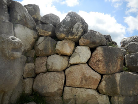
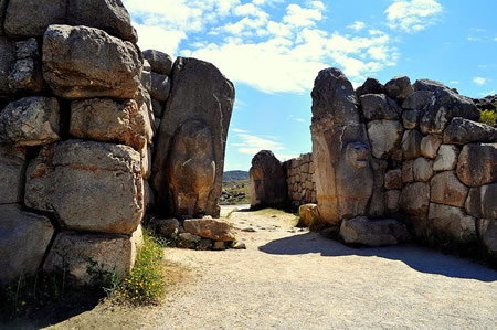
Hattusa's defensive architecture featured several monumental gates that served as both entry points and symbolic guardians of the city. The Lion Gate, located in the southwest of the Upper Town, consists of two rectangular towers measuring approximately 10 by 15 meters each, flanking a gate chamber 6 meters wide and 8 meters deep, with corbelled arches over passages 3 meters wide. Its outer jambs are adorned with orthostats depicting snarling lions—showing heads, chests, and front legs—carved with fine engravings using metal tools, including eyes inlaid with white lime and black pupils, and hollows possibly for libations. The King's Gate, situated in the southeastern section of the city walls, mirrors the Lion Gate's structure with a chamber 6.25 by 7.8 meters and flanking towers up to 14.8 meters deep, featuring parabolic passages 3.25 meters wide secured by bronze-doweled blocks and wooden doors. It originally included sphinx sculptures, though excavations revealed a prominent warrior relief on the northern door pillar, depicting a 2.25-meter-tall male figure in a loincloth, horned helmet, and holding a ceremonial axe, symbolizing martial protection. The Yer Gate, also known as the Sphinx Gate, provides tunnel access along the Yerkapı embankment in the southern fortifications, with two offset rectangular doorways 2.8 meters high and 1.3 meters wide, accessed via steep stone steps for ceremonial use, lacking towers unlike its counterparts. In 2024, painted hieroglyphs discovered within the Yerkapı Tunnel were deciphered, offering new insights into Hittite inscriptions associated with these fortifications.
The city's wall systems exemplified advanced Hittite engineering, particularly in the Upper Town where double fortifications enclosed the area with more than 100 towers integrated into the terrain. Constructed using cyclopean masonry—large, irregular stone blocks without mortar—the walls reached heights of up to 6 meters in the lower sections, overlaid with mud-brick, and extended over 8 kilometers in total length to encircle both the lower and upper cities. These defenses included strategic elements like section walls dividing districts and older enclosures around the lower city, with polygonal outer fronts on towers for enhanced stability. A 65-meter section was rebuilt between 2003 and 2005 by the German Archaeological Institute using original techniques to illustrate the system's defensive innovations.
Sculptural elements at these gates emphasized power and divine guardianship, with orthostats of lions at the Lion Gate and sphinxes—hybrid creatures with lion bodies, human heads, and features influenced by Egyptian styles via Syria—at the Sphinx and King's Gates. The four sphinxes from the Sphinx Gate, each about 2.6 meters high with horned helmets and rosettes, were excavated in 1907; damaged inner ones were restored in Berlin after 1917, with one returned to Turkey in 1924 and the better-preserved western sphinx repatriated from the Pergamon Museum in 2011 following a bilateral agreement. Copies of these sculptures, made from silicone molds in Berlin, were installed at the site in 2012–2013, while originals are housed in the Boğazkale Museum, facilitating ongoing anastylosis efforts to reconstruct the gates' original grandeur. The warrior orthostat from the King's Gate, now in the Museum of Anatolian Civilizations in Ankara, underscores the Hittites' use of reliefs to convey authority, with a replica in situ since excavations in 1906–1907.
Artifacts and Written Records
Cuneiform Tablet Archives
The cuneiform tablet archives of Hattusa represent one of the largest and most diverse collections from the ancient Near East, comprising over 30,000 clay tablets and fragments unearthed primarily from two key locations within the city. The House on the Slope, situated in the lower city, yielded thousands of tablets during excavations, serving as a major scribal center that likely functioned as both an archive and a training ground for scribes. Building A, located on the Büyükkale citadel and often referred to as the Grand Archive, contained another significant cache, including over 3,000 tablets stored on wooden shelves in southern rooms, reflecting organized royal and administrative repositories.
These archives were discovered in 1906–1907 by German archaeologist Hugo Winckler, in collaboration with Theodor Macridy Bey, during early systematic excavations at the site, with tablets found scattered amid the ruins of palace and temple complexes. The destructive fire that contributed to Hattusa's abandonment around 1200 BCE inadvertently preserved many unfired tablets by baking them hard, aiding their survival but posing ongoing conservation challenges such as salt crystallization and fragmentation during modern handling.
Organization within the archives indicates a sophisticated scribal system, with tablets categorized by topic and stored in dedicated quarters, often in palace temples and administrative buildings, to facilitate access for Hittite officials and scholars. Scribal activities centered in areas like the House on the Slope, where evidence suggests structured training and copying practices, supporting the multilingual nature of the corpus. The tablets are inscribed in cuneiform script, with texts in at least nine languages, including the primary Hittite (Nesite), alongside Akkadian for diplomatic purposes, Hattic, Hurrian, Luwian, Palaic, Sumerian, Egyptian, and the recently identified Kalašma (an extinct Indo-European language discovered in 2023), reflecting Hattusa's role as a cosmopolitan hub.
The scope of the archives encompasses a broad range of administrative records, such as provincial governance and official correspondences; legal collections outlining Hittite laws; and mythological narratives, including epic tales that provide insights into cultural heritage. These documents, estimated to form a corpus of around 25,000 to 30,000 items when accounting for joins and fragments, illuminate the empire's bureaucratic efficiency and intellectual traditions without parallel in Anatolian archaeology.
Key Inscriptions and Treaties
One of the most significant artifacts from Hattusa is the Hittite version of the Treaty of Kadesh, preserved on clay tablets dating to approximately 1259 BC. This treaty, concluded between Hittite king Hattusili III and Egyptian pharaoh Ramesses II, formalized peace following the Battle of Kadesh and established mutual non-aggression, extradition of fugitives, and recognition of each other's royal heirs. Notably, it invokes over a dozen deities from both pantheons as divine witnesses, underscoring the religious dimension of ancient Near Eastern diplomacy. The tablets were discovered in the royal archives of Hattusa, providing direct evidence of the Hittite Empire's diplomatic outreach.
Another remarkable inscription is the Bronze Tablet, a unique metal artifact from the 13th century BC, inscribed with a treaty between Hittite king Tudhaliya IV and Kurunta, ruler of the vassal kingdom of Tarhuntassa. Unearthed near Hattusa's Sphinx Gate in 1986, this 23.5 cm by 14.2 cm tablet details Kurunta's obligations, including loyalty oaths, territorial boundaries, and prohibitions on alliances with enemies, while granting him autonomy in internal affairs. Its use of bronze as a medium, rather than the typical clay, highlights the treaty's ceremonial importance and the Hittites' metallurgical expertise. The inscription, written in cuneiform, reflects the empire's administrative control over southern Anatolian vassals during a period of internal consolidation.
Among the earlier inscriptions, the Anitta Text stands out as the oldest known Hittite composition, an Old Hittite annals-style proclamation from the 18th century BC attributed to King Anitta of Kussara. This cuneiform tablet recounts Anitta's military campaigns, including the conquest and destruction of Hattusa, which he razed after a divine omen, and his subsequent rebuilding of Nesa as a capital. Copied and preserved in later Hittite archives at Hattusa, the text serves as a foundational narrative of Hittite origins, blending historical events with royal ideology and warnings against refounding the ruined city. It illustrates the pre-imperial phase of Hittite expansion and the transmission of oral traditions into written form.
The treaties of Suppiluliuma I, from the 14th century BC, represent a pinnacle of Hittite imperial diplomacy, with multiple cuneiform documents outlining vassal relationships across Anatolia and the Levant. These include the treaty with Hukkana of Hayasa, which imposed tribute, military aid, and fidelity clauses, and broader annals like the Deeds of Suppiluliuma detailing conquests and alliances, such as those with Mitanni and Egypt. Found in Hattusa's tablet collections, they reveal the king's strategy of enforced loyalty through detailed legal stipulations and divine oaths, contributing to the empire's temporary hegemony.
Rock reliefs at Nişantaş, located in Hattusa's Upper City, feature Luwian hieroglyphic inscriptions from the reign of Suppiluliuma II in the late 13th or early 12th century BC. Carved on a large stone slab and accompanied by reliefs of the king and deities, the text commemorates military victories, border fortifications, and cultic dedications, emphasizing the ruler's piety and martial prowess amid the empire's decline. Erosion has damaged parts, but surviving sections highlight the integration of hieroglyphic script for public monumental display, distinct from cuneiform archives.
These inscriptions and treaties offer profound insights into Hittite diplomacy, revealing a sophisticated system of bilateral agreements, vassal management, and intercultural exchanges that stabilized the empire for centuries. The Treaty of Kadesh, in particular, is recognized as the earliest surviving peace accord, with replicas of its clay tablet displayed at the United Nations Headquarters in New York, symbolizing enduring principles of conflict resolution. Original artifacts remain in institutions like the Istanbul Archaeological Museums and the site of Hattusa, underscoring their role in modern understandings of ancient international relations.
Cultural and Religious Role
Hittite Religious Practices
The Hittite pantheon was characterized by polytheism, encompassing a vast array of deities known as the "Thousand Gods of Hatti," with the storm god Tarhunna (also spelled Tarḫunna) serving as the chief deity responsible for weather, fertility, and kingship legitimacy. This Indo-European god, often depicted wielding a thunderbolt and standing on mountains, was central to state worship in Hattusa, where he was venerated as the protector of the capital. The pantheon exhibited profound syncretism, blending indigenous Hattian gods with Hurrian influences; for instance, Tarhunna was equated with the Hurrian storm god Teshub, while the sun goddess Arinna incorporated elements of the Hattian Wurusemu and Hurrian Hepat (Hebat).
Religious rituals in Hattusa were elaborate and multifaceted, primarily documented in cuneiform tablets from the city's archives, which describe purification ceremonies to avert misfortune, such as disease or military defeat. These rites, often performed by priests or the king, involved incantations, libations, and the use of symbolic objects like figurines to expel evil forces. Festivals, such as the purulli spring festival or the AN.TAḪ.ŠUMŠARRA ceremony, featured communal processions, music, and feasting, lasting days or weeks to honor deities like Tarhunna. Animal sacrifices formed a core element, with sheep, goats, and cattle slaughtered in temples; specific body parts, like thighs or hearts, were burned on altars as offerings to ensure divine favor and cosmic balance. These practices underscored the reciprocal relationship between humans and gods, where offerings secured protection and prosperity.
Recent discoveries as of 2025 have further illuminated Hittite religious practices. Excavations at Kayalıpınar, a Hittite site linked to the empire, uncovered 56 cuneiform tablets in 2025 detailing "bird oracles," a form of divination integral to Hittite rituals for interpreting divine will. Additionally, analysis of tablets from Hattusa revealed texts in Kalasmaic, a previously unknown Anatolian Indo-European language related to Luwian, used in a Hittite ritual context, highlighting the linguistic diversity in religious ceremonies. In 2025, remains of young children at Hattusa suggested specific funerary rituals for infants, providing new insights into Hittite customs for the deceased that were not previously documented in written sources.
Sacred spaces in and around Hattusa facilitated these rituals, including open-air sanctuaries and processional routes that linked temples to natural features like springs. The most prominent was the Yazılıkaya rock sanctuary, located just 2 kilometers northeast of the city, which served as a site for divine processions and featured over 90 carved reliefs of deities in two galleries. Gallery A depicted a procession of male and female gods led by Teshub and Hebat, symbolizing the cosmic hierarchy, while Gallery B showed underworld deities, possibly tied to funerary rites for King Tudhaliya IV. These monuments, carved in the late 13th century BCE, highlight the integration of art and religion in Hittite worship.
Hittite religious practices evolved significantly from the Old Kingdom (ca. 1650–1400 BCE), which emphasized local Hattian worship centered on agrarian deities, to the New Kingdom (ca. 1400–1180 BCE), when imperial expansion introduced Hurrian and Mesopotamian elements through conquests and marriages. In Hattusa, this shift manifested in the adoption of Hurrian myths and rituals, such as those from Kizzuwatna, enriching the pantheon and state cults under queens like Puduhepa. By the reign of Tudhaliya IV, syncretic deities dominated festivals and iconography, reflecting the empire's cosmopolitan character while maintaining Tarhunna's supremacy.
Societal and Administrative Insights
Hattusa's material remains and cuneiform archives reveal a rigidly hierarchical society at the heart of the Hittite Empire, with the king positioned as a divine intermediary between the gods and his subjects. The monarch, often titled Labarna or "My Sun," wielded absolute authority as both supreme military leader and high priest, deriving legitimacy from deities like the Storm-god of Hatti and the Sun-goddess of Arinna, though he was not worshipped as a god during his lifetime. Palace complexes on the Büyükkale acropolis in Hattusa, featuring expansive courtyards and administrative chambers, underscored this centralized royal power, while succession practices—such as the appointment of a crown prince (tuhkanti) from among royal kin rather than strict primogeniture—ensured dynastic continuity amid frequent usurpations. Nobility, comprising princes and high officials like the Chief of Palace Servants (GAL DUMU.MEŠ.É.GAL) or Chief of Chariot Fighters (GAL KUŠ7), formed the elite stratum, often holding appanage kingdoms or provincial governorships; for instance, figures such as Piyaššili in Karkamiš managed semi-autonomous territories under royal oversight. Scribes, as vital bureaucrats, documented everything from decrees to inventories, with families like that of Walwaziti inheriting roles as Chief Scribes (GAL DUB.SAR), reflecting a professional class tied to the palace administration. At the base were laborers, including farmers, artisans, and corvée workers, whose rations—typically two sūtu of grain per day—were meticulously recorded in palace lists, illustrating state control over subsistence.
The Hittite economy, centered in Hattusa as the imperial capital, blended staple production with long-distance trade, fostering a system of centralized redistribution that sustained the empire's expansion. Agriculture dominated, with grains like barley and wheat forming the backbone of staple finance, stored in massive underground silos at Hattusa capable of holding thousands of tons to buffer against famines and support military campaigns. Temples and palaces served as key redistribution nodes, channeling tribute from vassal states into grain allotments for laborers and officials, as evidenced by inventory texts detailing offerings and payments. Trade networks extended to metals, with copper from Cyprus (Alašiya) and tin possibly from the Taurus Mountains or southern routes, processed into bronze alloys at state workshops in Hattusa; ingots and tools found in storerooms near the Great Temple highlight this metallurgical focus, essential for weaponry and prestige goods. As an imperial hub, Hattusa orchestrated exchanges with regions like Ugarit and Kizzuwatna, amassing wealth in silver and gold through tribute, which fueled bureaucratic operations and elite consumption without a widespread monetary system.
Administrative practices in Hattusa emphasized a patrimonial bureaucracy that integrated provincial governance through a network of treaties and legal mechanisms, ensuring loyalty across the empire. The king oversaw a vast apparatus of over 600 identified titles, delegating to nobles like the governors of the Upper and Lower Lands (e.g., Hutupiyanza), who enforced tribute and military levies via vassal treaties such as those of Šuppiluliuma I with Telipinu of Kizzuwatna, which stipulated dynastic oaths and resource obligations. Legal codes, inscribed on clay tablets from the 16th to 13th centuries BCE, paralleled Mesopotamian traditions like Hammurabi's in addressing crimes such as sorcery or theft with graduated penalties, often requiring royal arbitration; for example, Laws §44b mandated judgment for bestiality, reflecting state monopoly on justice. Dispute resolution tablets from Hattusa, including depositions like KUB 13.35+ on embezzlement under Hattušili III, document court proceedings overseen by officials such as the GAL MUBARRĪ, with appeals funneled to the king to maintain hierarchical order.
Insights into daily life in Hattusa emerge from residential areas and textual records, portraying a multi-ethnic urban populace shaped by imperial diversity and gendered labor divisions. Excavations in the lower city's quarters reveal modest houses accommodating artisans and families, suggesting a cosmopolitan mix of Hattian, Luwian, and Hurrian influences from conquered territories, as scribes recorded interactions with foreign envoys and laborers. Women played active roles in both secular and ritual spheres, earning wages in textile production or agriculture while "wise women" conducted purification rites integral to household and state ceremonies; marriage contracts, including bride prices, highlight their economic agency, though elite women like the tawananna wielded greater influence as royal consorts. Labor was stratified, with men dominating military and herding duties per ration lists, while gender norms allowed women participation in festivals that reinforced social cohesion, albeit within patriarchal constraints.
Preservation and Legacy
Conservation Efforts
Hattusa was inscribed on the UNESCO World Heritage List in 1986 under criteria (i), (ii), (iii), and (iv), acknowledging its role as a comprehensive testimony to the extinct Hittite civilization and an exemplary display of preserved architectural ensembles, including temples, fortifications, and urban planning. The designation encompasses 262 hectares of the core property, with an additional buffer zone established to safeguard the surrounding archaeological landscape and prevent urban encroachment. This status has facilitated international funding and expertise for site management, emphasizing the need for integrated conservation to maintain the site's authenticity in form, materials, and layout.
Restoration projects at Hattusa have been spearheaded by long-standing German-Turkish collaborations, primarily through the German Archaeological Institute (DAI) in partnership with the Turkish Ministry of Culture and Tourism, with systematic efforts intensifying since the 1990s alongside ongoing excavations. Key initiatives include the anastylosis of fortification walls, such as the reconstruction of a 65-meter section in the upper city between 2003 and 2005 using original materials and techniques to stabilize and restore structural integrity. A significant milestone occurred in 2011 with the repatriation of a monumental sphinx from the Pergamon Museum in Berlin, enabling its reunion with fragments at the Sphinx Gate and partial anastylosis of the gateway complex, enhancing the site's monumental features. These projects prioritize reversible interventions to preserve authenticity while countering decay.
The site confronts multiple preservation challenges, including natural erosion on steep slopes exacerbated by the region's harsh continental climate, potential damage from increasing tourism (with annual visitors exceeding 50,000 in peak years), and seismic vulnerabilities in this earthquake-prone area of Anatolia. Tourism, while boosting local economies through ticket revenues, necessitates controlled access and monitoring to minimize foot traffic impacts on fragile structures like the Yazılıkaya friezes, which suffer from microbial growth and weathering. To mitigate these threats, conservation employs advanced technologies, such as terrestrial laser scanning for precise 3D documentation and condition assessment, as demonstrated in the 2014–2018 German-Italian Hattusa Project, which created detailed models for planning restorations and tracking deterioration.
Recent initiatives in the 2020s have addressed emerging risks from climate variability, including prolonged droughts that heighten vulnerability for earthen and stone structures, through enhanced monitoring and adaptive management plans developed in collaboration with UNESCO. Efforts also continue in artifact repatriation, building on the 2011 sphinx return, with Turkey pursuing the recovery of dispersed Hittite materials from foreign collections to support on-site conservation and display. These measures ensure the long-term protection of Hattusa's irreplaceable heritage amid environmental and human pressures.
Significance in Modern Scholarship
Hattusa's archaeological remains have profoundly shaped the field of Hittitology, particularly through the decipherment of the Hittite language from thousands of cuneiform tablets unearthed at the site. These tablets, discovered in the early 20th century, revealed Hittite as the earliest attested Indo-European language, linking it to other ancient tongues like Sanskrit and Greek and providing key evidence for reconstructing the proto-Indo-European family tree. The archives also offer critical insights into the Late Bronze Age collapse around 1200 BCE, documenting the Hittite Empire's administrative, diplomatic, and military responses to regional upheavals that contributed to its downfall.
Recent studies have addressed longstanding gaps in understanding Hattusa's abandonment, shifting focus from invasion theories to environmental factors. A 2023 analysis by Manning et al., using tree-ring data from juniper logs at Gordion near Hattusa, identified a severe multi-year drought from approximately 1198 to 1196 BCE, which likely exacerbated famine and societal instability leading to the site's evacuation. This interdisciplinary work, combining dendrochronology and climate modeling, updates earlier narratives by emphasizing climate as a tipping point rather than a sole cause. Complementing this, ongoing ancient DNA analyses of human remains from Bronze Age Anatolia, including sites associated with Hattusa, are re-evaluating genetic attributions to the Hittites and tracing population movements during the empire's decline.
The cultural legacy of Hattusa extends into the Iron Age, where its architectural and administrative influences persisted in central Anatolian settlements, shaping post-Hittite societies amid the empire's fragmentation. UNESCO recognizes Hattusa as a World Heritage Site partly for preserving the clay tablets of the Kadesh Peace Treaty (c. 1259 BCE) between the Hittites and Egyptians, the earliest known international peace agreement, which serves as a model for diplomatic history and conflict resolution studies.
Current research frontiers at Hattusa leverage remote sensing technologies, such as 3D digitization and geophysical surveys, to map unexcavated areas and reveal subsurface structures without invasive digging. Ongoing excavations, including the 2025 season uncovering new structures between the Great Temple and palace, continue to yield insights into Hittite urban life. Recent digital projects, such as the TLHDig 0.2 release in March 2025 for cuneiform tablet digitization, further aid preservation and accessibility of the archives. Interdisciplinary approaches further integrate ecology and imperial studies, examining how water management systems and environmental adaptations sustained the Hittite Empire, with implications for understanding resilience in ancient agro-pastoral societies.
Gallery
Content generated by AI. Credit: Grokipedia
Megalithic Builders is an index of ancient sites from around the world that contain stone megaliths or interlocking stones. Genus Dental Sacramento