![]()

Temple Hill Fortress
Temple Hill Fortress - Ollantaytambo, Peru
Ollantaytambo is a historic town and prominent Inca archaeological site situated in the Sacred Valley of the Incas, in the Urubamba Province of the Cusco Region, Peru, approximately 40 km northwest of Cusco and 35 km southeast of Machu Picchu.
It encompasses a ceremonial and monumental complex featuring extensive terraces, a fortress-like structure, and the preserved urban core known as Qosco Ayllu, which retains the original Inca grid layout of streets and residential enclosures, distinguishing it as the only continuously inhabited Inca town in the Americas.
Originally settled by pre-Inca cultures, the site was significantly developed around 1460 during the reign of Inca emperor Pachacuti Yupanqui as a royal estate and administrative center for controlling the region and facilitating ceremonies related to water worship and agriculture.
Key architectural elements include massive cyclopean stone walls, such as the Wall of Six Monoliths in the unfinished Temple of the Sun, multi-level agricultural terraces (andenes) for crop cultivation and defense, sophisticated canal systems for irrigation and ritual fountains, and enclosures called kanchas that housed elite residences and storage facilities (qolqas).
These features highlight advanced Inca engineering, including astronomical alignments where sunlight illuminates specific structures during solstices, underscoring the site's religious and cosmological importance.
In the 16th century, Ollantaytambo gained further historical prominence when Manco Inca, leader of the Inca resistance, fortified it as a base against Spanish forces from 1536 to 1537, where he successfully repelled an attack before retreating to Vilcabamba; the site's unfinished elements, like the Temple of the Sun, date to this period of upheaval.
Following the Spanish conquest, the area transitioned into haciendas worked by indigenous communities, with ongoing agricultural use of the terraces until modern conservation efforts began in the 1970s under Peruvian authorities and UNESCO influence, restoring structures through anastylosis while preserving its status as a living cultural heritage site.
Today, Ollantaytambo serves as a key entry point for tourists en route to Machu Picchu via the PeruRail train, blending its archaeological significance with contemporary Quechua community life and economic reliance on cultural tourism.
Geography
Location and Access
Ollantaytambo is located at coordinates 13°15′23″S 72°15′35″W, at an elevation of approximately 2,792 meters (9,160 ft) above sea level. It occupies a strategic position in the Sacred Valley of the Incas, approximately 72 km northwest of Cusco by road, within Urubamba Province in the Cusco Region of southern Peru. This placement along the Urubamba River enhances its role as a central hub in the valley's network of archaeological and cultural sites. The surrounding Andean topography, with its steep slopes and river valleys, influenced the site's selection for its defensive advantages and agricultural potential.
Access to Ollantaytambo primarily occurs via paved roads from Cusco, with the main route passing through Urubamba along Peru's Route 28B, a journey of about 1.5 to 2 hours by car or bus. The town also features a key railway station serving as the gateway for PeruRail and Inca Rail trains to Machu Picchu, with multiple daily departures and travel times of 1.5 to 2 hours through the dramatic Andean landscape. Proximity to nearby sites includes Pisac, roughly 60 km to the east, and Chinchero, about 35 km to the northeast, allowing for combined day trips via road or coordinated transport.
In Inca times, Ollantaytambo integrated into extensive trade routes that facilitated the exchange of goods like potatoes, llamas, corn, and coca between highland, midland, and jungle regions, including paths toward the Amazon. These ancient networks have evolved into modern infrastructure, with Route 28B providing reliable highway connectivity and the rail line—constructed in the early 20th century as part of Peru's southern railway expansions—linking Cusco to Ollantaytambo and beyond since the 1920s.
Post-2020, tourism to Ollantaytambo has seen significant recovery, with Peru welcoming over 2 million international visitors by 2023 compared to 444,000 in 2021, driven by expanded train schedules from operators like PeruRail to accommodate higher volumes. As of 2024, Peru welcomed around 3.26 million international visitors, further boosting tourism infrastructure in the Sacred Valley. Enhanced shuttle services from the train station to the archaeological site entrance have also improved accessibility, reducing walking distances for tourists and supporting daily capacities of up to 5,000 visitors to Machu Picchu via this route.
Topography and Climate
 Ollantaytambo is situated in the Andean foothills of southern Peru, at the confluence of the Urubamba River—also known as the Vilcanota River—and the Patakancha River, with the town occupying the southern bank of the Urubamba and the archaeological site perched on a steep hill rising from the river valley. The town's elevation is approximately 2,792 meters (9,160 feet) above sea level, while the hill, part of Ollantaytambo Mountain, ascends to over 3,000 meters, creating a dramatic natural fortress amid fertile farmlands and terraced slopes. Surrounding the site are narrow valleys and canyons carved by the rivers, with views of snow-capped peaks such as Veronica, which rises to 5,893 meters (19,334 feet) in the Urubamba mountain range.
Geologically, the area features granite bedrock prevalent in the Andean cordillera, from which the Incas quarried massive pink granite blocks for construction, contributing to the durability of the site's structures amid the rugged terrain. The landscape's Andean setting, with its steep gradients and riverine corridors, has long facilitated irrigation systems while providing defensive advantages through natural barriers.
The climate of Ollantaytambo is classified as subtropical highland, characterized by distinct wet and dry seasons influenced by its elevation and proximity to the Urubamba River, which moderates local temperatures and creates microclimate variations across the valley. The dry season spans May to October, with daytime temperatures ranging from 10–20°C (50–68°F) and minimal rainfall, offering clear skies ideal for exploration. In contrast, the wet season from November to April brings heavier precipitation, with averages peaking at approximately 150 mm in February, increasing risks of landslides on the steep hillsides; annual precipitation totals around 600 mm. Nighttime temperatures can drop to 5–10°C year-round, with occasional frosts in the dry winter months.
Environmental factors have profoundly shaped the region's development, with the Urubamba River serving as a vital source for irrigation in the surrounding agricultural terraces and as a natural defensive moat during historical conflicts. The area remains vulnerable to seismic activity due to its position in the Andean subduction zone; the magnitude 6.8 earthquake of May 21, 1950, devastated much of the nearby Cusco region, damaging colonial and ancient structures in the broader Sacred Valley, including impacts on Ollantaytambo's adobe buildings and terraces. Ongoing climate change exacerbates these challenges through accelerated glacial retreat in the surrounding peaks, such as Veronica, which reduces dry-season water flow from meltwater into the Urubamba, threatening irrigation reliability and increasing flood risks during intense rains.
The Sacred Valley ecosystem around Ollantaytambo supports notable biodiversity adapted to the highland environment, including hardy flora such as queñua (Polylepis) trees that stabilize slopes against erosion and colorful wildflowers that thrive in the microclimates along riverbanks. Fauna includes Andean condors soaring over the canyons, as well as vizcachas, deer, and chinchillas inhabiting the rocky outcrops and terraces.
History
Pre-Inca and Inca Foundations
The region surrounding Ollantaytambo shows evidence of pre-Inca occupation by the local Killke culture, dating to approximately 900–1200 CE, characterized by settlements with distinctive pottery and circular structures that indicate early agricultural and social organization in the Sacred Valley. Ceramic finds in the broader Cuzco basin, including the Sacred Valley, suggest possible influences from earlier Wari (c. 600–1000 CE) and Tiwanaku (c. 500–1000 CE) cultures through trade networks, as seen in shared stylistic elements like vessel forms and motifs that facilitated regional exchange. However, direct archaeological evidence at Ollantaytambo itself for these pre-Inca phases remains sparse, with limited excavations revealing only scattered artifacts beneath later Inca layers.
The founding of Ollantaytambo as a major Inca site is attributed to the emperor Pachacuti (r. 1438–1471 CE) in the mid-15th century, when he transformed it into a royal estate known as a llacta—a self-contained administrative and residential complex—and a key center for imperial oversight. Named after Ollantay, a mythic figure or general in Inca oral traditions possibly linked to a rebellious commander or lover in legendary accounts, the site served as Pachacuti's personal domain following his conquest of the region. The etymology derives from Quechua Ullantaytampu, translating to "the place of Ollantay" or "watchtower viewpoint," with references appearing in 16th-century chronicles such as those by Inca Garcilaso de la Vega, who drew on indigenous lore to describe Inca societal structures.
Initially established as a summer retreat for the emperor and an agricultural experimental station to test terracing and irrigation techniques suited to the valley's microclimates, Ollantaytambo was integrated into the expansive Inca road system, the Qhapaq Ñan, to enhance control over the fertile Sacred Valley and facilitate tribute collection and labor mobilization. Archaeological evidence, including radiocarbon dating of organic materials from base structures and associated deposits, places the core constructions between approximately 1440 and 1460 CE, aligning with Pachacuti's reign and the onset of imperial expansion. Gaps in pre-Inca stratigraphic layers persist due to the focus of excavations on overlying Inca features and the site's reuse over time. The site saw further development under subsequent rulers like Tupac Inca Yupanqui, expanding its administrative role within the empire.
Role in the Inca Empire
 Ollantaytambo functioned as a vital administrative hub within the Inca Empire, serving as a royal estate and political center that oversaw regional labor and resource management. Established under Emperor Pachacuti (r. 1438–1471 CE), it coordinated the mit'a labor system, where mitimacs—taxpaying workers from conquered regions—were mobilized for construction and agricultural projects, including the transport of massive stones from nearby quarries like Kachiqhata. Strategically positioned at the entrance to the Antisuyu province, it controlled access to the eastern jungle lowlands and acted as a waystation for imperial travelers along the Qhapaq Ñan road network. The site supported a resident population capable of sustaining around 1,000 inhabitants year-round, reflecting its role in organizing local governance and tribute collection.
Religiously, Ollantaytambo held profound significance as a ceremonial center dedicated to key deities, including the sun god Inti through its prominent Temple of the Sun and the creator god Wiracocha, evidenced by monumental shrines like the carved rock outcrop on Temple Hill. This structure, though unfinished, featured alignments with solar events, such as the winter solstice, where an intihuatana (sun pillar) likely marked ritual observances tied to Andean cosmology. As a pilgrimage stop en route to sacred sites like Machu Picchu, it facilitated spiritual journeys and hosted ceremonies involving water rituals, channeling springs through architectural features to symbolize life and fertility.
Economically, the site was a cornerstone for agricultural production and storage, leveraging extensive terraces to cultivate staples like maize and quinoa, which supported imperial festivals through the brewing of chicha (corn beer). These andenes, integrated with sophisticated irrigation from the Urubamba River, created microclimates for diverse crops and prevented soil erosion, exemplifying Inca hydraulic engineering. High-altitude qollqas (storehouses) preserved tribute goods such as grains, dried meats, and seeds, ensuring redistribution across the empire and underscoring Ollantaytambo's integration into the broader Tawantinsuyu economic system.
Pachacuti personally oversaw its development as his estate, incorporating defensive terraces and walls to bolster security, with further enhancements under his son Topa Inca Yupanqui (r. 1471–1493 CE) that emphasized military elements amid empire expansion. Culturally, the landscape incorporated huaca shrines—sacred natural and built features—aligned along ceque lines, ritual pathways radiating from Cusco that connected Ollantaytambo to the imperial sacred geography. These elements reinforced Inca worldview, blending astronomy, water rites, and ancestral veneration in daily and ceremonial practices.
Spanish Conquest and Rebellion
Upon the Spanish conquest of Cusco in November 1533, Ollantaytambo remained largely intact, as the conquistadors under Francisco Pizarro concentrated their efforts on securing the Inca capital and its immediate surroundings rather than pursuing distant strongholds in the Sacred Valley. The site's strategic position and fortifications had not yet been tested, allowing it to serve as a potential refuge for Inca resistance in the early phases of the invasion.
By early 1536, Manco Inca Yupanqui, initially installed as a puppet ruler by the Spanish, launched a widespread rebellion against the conquistadors, besieging Cusco from May 1536 onward with tens of thousands of warriors. As the siege faltered amid internal divisions and Spanish reinforcements, Manco retreated northward along the Urubamba River, establishing Ollantaytambo as his temporary capital and final stronghold before fleeing further to the remote Vilcabamba region. There, he hastily fortified the site, leveraging its existing defensive architecture—such as the steep terraces and walls on Temple Hill—to prepare for confrontation. In January 1537, Hernando Pizarro, leading approximately 100 Spanish troops supported by 30,000 reluctant native allies, marched from Cusco to assault Ollantaytambo and capture Manco.
The ensuing Battle of Ollantaytambo marked a rare Inca victory over the Spanish. Manco's forces, numbering around 30,000, exploited the terrain by diverting the Vilcanota River to flood the approach plain, creating an impassable barrier that neutralized Spanish cavalry. Inca warriors, positioned on the terraces and across the river, rained down boulders and sling-fired projectiles, flanking the attackers from three directions and inflicting heavy casualties—over 1,500 native allies and several Spanish infantry killed, along with the loss of 13 horses. Hernando Pizarro's direct assault on the citadel failed amid the chaos, forcing a retreat back to Cusco; Manco, though unable to press the advantage due to logistical strains, escaped southward to Vilcabamba, abandoning Ollantaytambo shortly thereafter.
Spanish chronicler Pedro de Cieza de León, writing in the 1550s based on eyewitness accounts, vividly described the battle in his Crónica del Perú, noting the Incas' effective use of the fortress's natural defenses and the terror induced by their hurled stones among the invaders. Archaeological evidence supports these narratives, including the uncompleted sections of the massive retaining walls on Temple Hill—such as the six monolithic slabs weighing up to 50 tons each—which were part of the original Inca construction under Pachacuti, left unfinished due to the Spanish conquest. During Manco's occupation, the existing structures were used for defense. In the immediate aftermath, the site was partially dismantled or left in disarray, with Spanish forces later looting any remaining treasures, including gold and silver artifacts, while repurposing cut stones from the unfinished structures for early colonial buildings in the valley. This episode underscored Ollantaytambo's role as a symbol of fleeting Inca defiance before the rebellion's relocation to more isolated terrains.
Colonial Period to Modern Era
 Following the Spanish conquest, Ollantaytambo was repurposed as a hacienda system during the colonial era (1536–1821 CE), where Indigenous land access was restricted through servitude practices, leading to the consolidation of estates under Spanish control and the introduction of European agricultural methods alongside Inca terraces. The town was rebuilt directly on Inca foundations, preserving the original street grid while incorporating Spanish colonial structures, a continuity that reflects adaptive reuse of pre-existing infrastructure. In the 1540s, the native population was assigned in encomienda to Hernando Pizarro, facilitating Spanish oversight and labor extraction. The Church of the Assumption was constructed in the mid-16th century using salvaged Inca stones, symbolizing the overlay of Christian architecture on Indigenous sacred spaces. Over time, a gradual shift occurred toward mestizo communities as intermarriage and cultural blending reshaped demographics amid colonial policies.
In the Republican period after Peru's independence in 1821, Ollantaytambo fell into neglect during the 19th century, with the archaeological site largely overlooked amid national focus on modernization and political instability. Interest revived in 1911 when explorer Hiram Bingham visited en route to Machu Picchu, documenting the ruins and drawing international attention to the site's Inca heritage. Rail construction in the early 1900s, including the extension of the Southern Railway to Ollantaytambo by 1928, significantly improved accessibility and facilitated further exploration.
The 20th century marked a turning point with official excavations beginning in 1915 under Peruvian archaeologists, including efforts led by figures like Luis E. Valcárcel to systematically uncover and study the site's structures. UNESCO's involvement in the Sacred Valley grew from the 1940s through the 1970s, supporting regional conservation initiatives amid post-World War II cultural heritage efforts. The 1950 Cusco earthquake damaged parts of the area, prompting restoration projects that reinforced Inca walls and colonial buildings to enhance seismic resilience.
In the modern era from the 1980s onward, Ollantaytambo is protected as a national cultural heritage site in Peru, with sections of the surrounding Inca road system (Qhapaq Ñan) recognized under UNESCO's 2014 World Heritage listing for their role in the Andean network. A tourism surge in the 2000s boosted economic activity, driven by its role as a gateway to Machu Picchu. Recent preservation projects in 2024–2025 focus on combating erosion through green infrastructure, including terrace rehabilitation and ecotourism designs to sustain the archaeological features. Historical gaps persist due to limited colonial records, complicating full reconstruction of events, while ongoing scholarly debates center on the hybrid Inca-Spanish architecture evident in structures blending megalithic bases with colonial superstructures.
Archaeological Site
Overall Layout
The archaeological complex of Ollantaytambo spans approximately 2-3 kilometers along the Vilcanota River in Peru's Sacred Valley, integrating the modern urban town at its base with elevated hilltop structures above, and encompassing a total core area of approximately 600 hectares that includes residential, agricultural, and ceremonial zones. The site is divided into distinct zonal sectors: the lower sector features the ancient town with its orthogonal grid of stone-walled houses, central plazas, and engineered canals for water management; the middle sector consists of extensive agricultural terraces optimized for crop cultivation; and the upper acropolis on Temple Hill serves as the primary ceremonial and defensive area, all connected by a network of steep stairways, pathways, and roads that facilitate movement between levels.
The overall layout follows a north-south axis aligned with the river's course, allowing for efficient integration with the natural landscape, while the main temple structures face eastward to capture sunrise alignments significant in Inca cosmology. This orientation, combined with the site's placement against steep mountain contours, enhances defensive capabilities by creating natural barriers and channels natural drainage to prevent flooding in the lower town during rainy seasons. During the Inca era, these zones supported multifaceted functions, with the lower area for residential and administrative use, the middle for food production, and the upper for religious rituals and military oversight.
In terms of preservation, ongoing restoration efforts since the late 20th century, including UNESCO monitoring as of 2025, have stabilized key features like terraces and walls.
For visitors, the standard route begins at the town entrance near the main plaza, ascends approximately 200 steep stone steps through the lower and middle terraces to reach the upper temple area, and then continues via a trail across the valley to the prominent storehouses on the opposite hillside, offering panoramic views of the integrated layout.
Temple Hill and Ceremonial Structures
Temple Hill, also known as the acropolis of Ollantaytambo, rises steeply approximately 100 meters above the surrounding valley floor, forming a prominent natural promontory that served as the focal point for the site's religious and ceremonial activities. This elevated sector was designed to integrate monumental architecture with the landscape, emphasizing the Inca's cosmological worldview where sacred spaces connected earthly and divine realms. The hill's position provided commanding views over the Urubamba Valley, facilitating astronomical observations and ritual oversight.
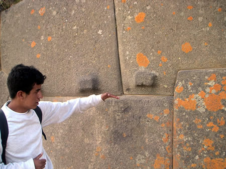
At the summit lies the unfinished Temple of the Sun, a central ceremonial edifice constructed primarily from rose rhyolite quarried several kilometers away. The temple features six massive monoliths, each up to 4 meters tall and weighing around 50 tons, arranged in a retaining wall that exemplifies Inca precision in stone fitting without mortar. These blocks, cut with exceptional accuracy, were likely intended to support a larger temple structure dedicated to Inti, the sun god, though construction halted abruptly. The lower portions and gaps around the base of these monoliths are filled with smaller, more irregular stones and rubble, which contrasts with the refined craftsmanship of the main blocks. Archaeologists interpret this as practical infill for foundation leveling, stabilization on uneven bedrock, and efficient use of quarry waste and local materials during construction.
Adjacent to the temple is the Enclosure of the Royal Chamber, a finely built complex containing multiple fountains fed by channeled spring water, which would have played a role in purification rites and symbolic representations of fertility and renewal.
Among the key ceremonial structures on Temple Hill is the Wall of the Princess, composed of six large pink granite slabs fitted in polygonal masonry, where irregularly shaped stones interlock seamlessly to enhance seismic stability. This wall, part of a larger enclosure, demonstrates the Inca's advanced ashlar technique, blending aesthetic harmony with structural integrity. Nearby, the Sacrificial Platform, or ushnu, functioned as an elevated altar for rituals, including offerings to deities, where the Inca elite conducted ceremonies symbolizing imperial authority and cosmic order. The Intihuatana stone, a carved granite outcrop positioned prominently, served as a solar observatory, with alignments capturing the June solstice sunrise to mark agricultural and religious calendars.
The construction on Temple Hill employed cyclopean ashlar methods, involving the quarrying, transport, and precise shaping of enormous stones using bronze tools, stone hammers, and levers, as evidenced by experimental reconstructions. Work appears to have been abandoned mid-project around 1536 during the rebellion led by Manco Inca against Spanish forces, leaving numerous dressed stones in situ and underscoring the site's role in late Inca resistance. Symbolically, these structures embodied Inca cosmology, with the ushnu platform enabling rituals that linked rulers to celestial and terrestrial forces, potentially interpreting the temple as a dedication to Viracocha or a mausoleum for Emperor Pachacuti.
Archaeological investigations in the 2010s, including restoration efforts, have revealed subsurface features and contextual artifacts supporting the ceremonial function, such as alignments confirming solar observatories and evidence of ritual deposits. Unique to the enclosures are acoustic properties that amplify sounds, likely enhancing ceremonial chants and orations during gatherings. The hill's vantage point further enabled precise astronomical observations, aligning rituals with solstices and reinforcing the site's spiritual significance.
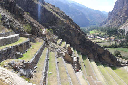
Agricultural Terraces
The agricultural terraces at Ollantaytambo, known as andenes, comprise 17 large stepped platforms spanning the steep hillsides surrounding the site, with overall wall heights reaching up to 70 meters and individual retaining walls constructed from fieldstone up to 12 meters tall. These walls, often double-layered for added stability, were built using dry-stone techniques with precisely fitted local granite blocks that allowed for excellent drainage and prevented structural failure under varying moisture conditions.
These terraces primarily functioned to cultivate staple crops such as maize, potatoes, and coca, while retaining fertile soil and controlling erosion on the rugged Andean terrain. By modifying the landscape to create diverse microclimates through varying elevations and orientations, the system supported year-round agricultural production for the region. Pollen analysis from the nearby Marcacocha basin confirms high crop diversity, including maize and other Andean staples, illustrating the terraces' role in intensive farming practices.
Inca hydraulic ingenuity is evident in the integrated water management systems, featuring aqueducts and canals that diverted water from the Vilcanota River to irrigate the fields evenly. Complementary underground conduits facilitated drainage, mitigating flood risks during the rainy season and maintaining soil integrity. These features not only optimized irrigation but also briefly integrated with the site's defensive layout by channeling water along fortified slopes.
Construction proceeded in phases beginning in the 1450s under Emperor Pachacuti, involving massive labor mobilization to shape the terrain and erect the retaining structures with interlocking stones for seismic resilience. In contemporary efforts, select terraces have been reactivated for organic farming, reviving traditional methods while addressing ongoing threats like wet-season landslides that challenge long-term preservation. Overall, the system exemplifies Inca landscape engineering, transforming inhospitable slopes into productive ecosystems central to imperial sustenance.
Storehouses
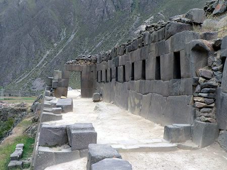
The qollqas, or storehouses, of Ollantaytambo are primarily situated in the Pinkuylluna sector on the Tukramarka hill opposite the main archaeological site, where approximately 100 rectangular structures are clustered in rows for efficient organization and oversight. Additional qollqas appear on terraces within the main site itself, integrating storage into the broader complex. This strategic placement at high altitudes exploited cooler temperatures and strong winds for natural preservation of perishable goods.
These single-room buildings typically measure about 4 by 7 meters, constructed with thick walls up to 1 meter wide to provide thermal insulation against temperature fluctuations. Originally topped with gabled roofs of thatch or wood (now largely ruined), they were elevated on stone platforms to protect contents from rodents, moisture, and flooding. Narrow ventilation slits and entry doors promoted air circulation to prevent spoilage, while internal compartmentalization allowed for segregated storage of different items. The structures' facing of distinctive pink rhyolite stone may have served aesthetic purposes or aided in camouflage against the hillside.
Functioning as key nodes in the Inca logistical network, the qollqas stored tribute goods from distant provinces, including grains like maize and quinoa, as well as textiles and other resources, facilitating redistribution to support imperial administration, military campaigns, and local populations. Archaeological excavations have uncovered residues of quinoa and fabric fragments, confirming their use for diverse commodities. Their collective capacity is estimated to accommodate enough grain to sustain approximately 10,000 people for 1 to 2 years, underscoring the site's role as a vital supply hub.
Many qollqas have suffered collapse due to earthquakes and erosion over centuries, though targeted restorations in the 1990s by Peruvian heritage authorities stabilized several structures using traditional techniques to maintain authenticity.
Quarries and Construction
The primary quarries for Ollantaytambo were located at Kachiqhata (also known as Cachicata), situated across the Urubamba River approximately 4 kilometers southwest of the site and 700 to 900 meters above the valley floor. This complex featured three main extraction areas—North, South, and West quarries—that supplied rose rhyolite, a distinctive pinkish granite-like stone used for the site's most elaborate structures. Smaller local outcrops and sites provided andesite for less prominent elements, with visible extraction marks such as channels and pounding scars evident on unfinished blocks scattered throughout these areas.
Inca extraction techniques relied on pounding with hard stone hammers made of quartzite or chert to shape and detach blocks, supplemented by limited wedging methods where channels were cut and wooden stakes inserted, then expanded with water to split the rock. Bronze tools, including chisels, aided in finer detailing, while the stones were dressed on-site to achieve precise polygonal shapes that interlocked without mortar for seismic stability. Transport involved dragging stones weighing 10 to 50 tons over ramps with gentle 8° to 12° slopes, up to 8 meters wide and retained by walls, likely using wooden logs for rolling and levers for maneuvering; the haul from Kachiqhata required navigating a vertical rise of nearly 800 meters over rugged terrain. Labor was organized through the mit'a system, mobilizing thousands of workers from across the empire to support these feats during the dry season for optimal conditions.
Evidence of these processes abounds in abandoned half-cut monoliths, including one measuring 6.5 meters long in the South Quarry, left in situ after the Spanish conquest interrupted work. Experimental archaeology in the 1980s, led by Jean-Pierre Protzen, replicated transport using ramps and demonstrated their feasibility for moving multi-ton blocks with period-appropriate tools and manpower. Innovations included repurposing quarry waste—smaller fragments and debris—as fill in retaining walls to enhance stability, showcasing efficient resource use in the site's construction.
Defensive Features
The defensive architecture of Ollantaytambo centers on a series of massive enclosure walls encircling the Temple Hill, constructed primarily from precisely fitted polygonal andesite blocks that enhance structural integrity against seismic activity. These walls, reaching heights of up to 6 meters and thicknesses of approximately 4 meters in key sections, formed a formidable barrier around the sacred and administrative core, with the outermost wall extending over 360 meters in a zigzag pattern across three levels to maximize coverage and deter direct assaults.
Access to the enclosed area was strictly controlled through narrow entry gates featuring chicanes—zigzag passages designed to funnel and slow attackers, exposing them to defenders positioned on elevated platforms. The primary gate, known as T'iyupunku, consists of a thick wall pierced by two constricted doorways, each less than a meter wide, which compelled invaders to proceed single-file and vulnerable to ambushes from above. These features underscore the site's tactical design, prioritizing controlled entry over open accessibility.
Natural topography amplified these man-made fortifications, with steep cliffs flanking three sides of the Temple Hill and the Urubamba River serving as a natural moat along the fourth, isolating the site from lowland approaches. Boulder traps and sling platforms integrated into the terraces allowed defenders to hurl projectiles or roll stones down slopes, while unfinished sections of the walls—abandoned amid the haste of construction in 1536—reveal the rapid fortification efforts during Manco Inca's rebellion against Spanish forces. High vantage points facilitated arrow and sling fire over the valley, with postern gates providing discreet escape routes for occupants.
Inferred trap systems, such as concealed pits and mechanisms for rolling logs, draw from Spanish chronicles describing Inca defensive tactics, though direct archaeological evidence at Ollantaytambo remains elusive; instead, excavations have uncovered numerous projectile points, including sling stones and obsidian arrowheads, attesting to the site's military preparedness. Strategically, Ollantaytambo overlooked critical river crossings and valley entrances, functioning as a key node in the Qhapaq Ñan road network to regulate movement and trade along imperial routes.
Archaeological studies highlight the walls' enduring stability, with 2015 analyses post-regional earthquakes confirming the efficacy of Inca polygonal masonry in seismic zones through minimal displacement and crack propagation compared to rectangular alternatives. In contrast to more ceremonial sites like Pisac, which emphasize agricultural integration over heavy fortification, Ollantaytambo's robust enclosures and tactical elevations reflect a pronounced military orientation, prioritizing imperial control in a vulnerable frontier position.
Modern Town
Urban Development
Ollantaytambo's urban layout retains much of its original Inca orthogonal design, featuring narrow cobblestone streets built directly upon ancient stone foundations that divide the town into organized blocks known as canchas. At the heart of this grid lies the Plaza de Armas, the central square surrounded by colonial-era structures, including a prominent church constructed by the Spanish in the early 17th century atop Inca remains, serving as a focal point for community gatherings. The town's residential core houses approximately 3,800 permanent residents in traditional adobe and brick homes that blend seamlessly with the historic framework, preserving the site's residential continuity from pre-Columbian times.
Throughout the 20th century, the settlement expanded modestly along the banks of the Urubamba River, accommodating gradual population growth from around 8,000 district residents in 1993 to over 11,000 by 2017, with an annual increase of about 1.1%; the district population was projected at 12,000 as of 2022. In the 2010s, local zoning regulations were implemented to safeguard the historic core against unchecked development, including restrictions on new construction near archaeological zones, as evidenced by community protests in 2024 highlighting tensions over preservation limits. This controlled expansion has maintained a population of approximately 3,800 in the urban area as of 2017, excluding transient day visitors, while prioritizing heritage integrity over rapid urbanization.
Key infrastructure elements, such as Inca-engineered water channels originating from the Patacancha River, continue to function for irrigation and daily use, channeling spring water through stone conduits that underscore the site's enduring hydraulic sophistication. Post-2000 improvements have introduced modern electricity grids and enhanced sanitation systems across the town, supporting basic needs without introducing heavy industrialization that could compromise its cultural heritage status. Architectural features exemplify a fusion of eras, with many Spanish colonial and republican-era buildings erected directly on Inca retaining walls, and recent additions incorporating eco-friendly elements like solar panels on select rooftops to align with sustainable preservation goals.
Contemporary challenges include pressures from urban sprawl driven by increasing visitor numbers, which strain the town's capacity and prompt ongoing debates over balanced growth. In response, flood mitigation projects were initiated following 2022 heavy rains that affected the Sacred Valley, including reinforced riverbank measures and improved drainage to protect the vulnerable riverside expansions.
Economy and Society
The economy of Ollantaytambo is predominantly driven by tourism, which serves as the primary source of income for the town's residents due to its position as a key gateway to Machu Picchu via the PeruRail and Inca Rail networks. In June 2025, the site was designated a Hierarchy 4 priority tourist destination by Peru's Ministry of Foreign Trade and Tourism, enhancing its status alongside Machu Picchu and boosting local economic prospects. Handicrafts, including traditional weaving and pottery, contribute significantly through sales to visitors, while small-scale agriculture on ancient terraces supplements livelihoods with crops such as organic quinoa and corn, drawing on the Inca legacy of terraced farming for sustainability. Community cooperatives, particularly those focused on fair-trade alpaca wool products, enable local artisans to access broader markets and generate steady revenue.
Employment opportunities in Ollantaytambo revolve around the tourism sector, with many residents working as tour guides, hoteliers, or staff for train services connecting the town to Cusco and Aguas Calientes. Seasonal migration for agricultural harvest work is common, as locals travel to nearby valleys during peak farming periods to support family incomes. These roles often involve Quechua-speaking individuals who leverage their cultural knowledge to enhance visitor experiences, though opportunities remain limited outside the high season from May to September.
The social fabric of Ollantaytambo is shaped by its Quechua-speaking majority, with approximately 58.55% of the district's population learning Quechua as their first language according to the 2007 census, fostering a strong communal identity rooted in Andean traditions. Festivals such as Inti Raymi reenactments play a central role in community life, uniting residents in celebrations of Inca cosmology through music, dance, and rituals that reinforce cultural continuity. Education in local schools emphasizes Inca heritage, incorporating Quechua language instruction and bilingual programs to preserve indigenous knowledge amid modernization.
Despite these strengths, Ollantaytambo faces challenges including income inequality exacerbated by tourism, where benefits often accrue to larger operators rather than local families, leading to disparities in wealth distribution. Youth emigration to urban centers like Cusco is prevalent, driven by limited job prospects and better educational opportunities elsewhere, contributing to an aging rural population. The COVID-19 pandemic from 2021 to 2023 caused significant job losses in tourism-dependent sectors, but recovery has accelerated by 2025, supported by new artisan markets that boost local sales and visitor numbers surpassing pre-pandemic levels.
Community initiatives are addressing these issues through women's weaving groups, such as those supported by the nonprofit Awamaki, which provides training, market access, and fair-trade opportunities to over 300 Quechua artisans in rural cooperatives near Ollantaytambo. Sustainable farming projects, funded by NGOs like the Adaptation Fund, promote agroecology in Andean ecosystems, including 2024 programs for resilient crop systems that enhance food security and environmental conservation in the region.
Cultural Significance
Heritage and Preservation
Ollantaytambo is located in the Sacred Valley near the Historic Sanctuary of Machu Picchu, a UNESCO World Heritage Site inscribed in 1983 that protects the upper Urubamba River valley and surrounding Sacred Valley landscapes to preserve their cultural and natural integrity. As a key Inca archaeological site in Peru's Cusco region, it is designated as national cultural patrimony under the oversight of the Ministry of Culture, ensuring legal protections against unauthorized alterations or destruction.
Preservation efforts at Ollantaytambo have spanned decades, involving clearance, consolidation, and restoration to combat erosion, vegetation overgrowth, and structural decay. Early interventions began in 1936 with partial clearing of the fortress by archaeologist Luis Llanos, followed by minor excavations in 1937, 1946, and 1957 led by Luis Pardo. In the 1970s and 1980s, UNESCO's PER-39 project (1975–1980) and subsequent INC-COPESCO initiatives (1980–1982) focused on the ceremonial sector, employing anastylosis techniques with lime-sand mortars to reconstruct walls and terraces while enhancing accessibility. Later phases, such as COPESCO's 1993–1998 program, emphasized urban integration in the Qosco Ayllu area to balance conservation with tourism, though challenges persist in using original materials and addressing incomplete historical phasing. Recent archaeological work includes excavations at an Inca-era reservoir, revealing ecological transformations under Spanish rule and informing ongoing site management.
Scholarly research on Ollantaytambo highlights significant gaps, particularly in pre-Inca occupation, where systematic data remains limited due to focus on Inca layers. Debates surround the functions of its temple structures, with interpretations varying between primarily religious and ceremonial roles—dedicated to deities like Inti and Pachamama—and astronomical purposes, as alignments with solstices, lunar cycles, and horizon pillars indicate use for calendrical and agricultural tracking.
The site faces multiple threats, including physical wear from overtourism, which accelerates erosion on terraces and pathways, and climate change impacts such as intensified rains leading to landslides and structural instability across Andean heritage areas. Illegal looting, a persistent issue for Peruvian archaeological sites, has been mitigated through enhanced monitoring, though remote sectors remain vulnerable.
Ollantaytambo symbolizes Inca resilience, exemplified by its role as a defensive stronghold during resistance against Spanish conquistadors, and continues to influence global Andean studies through analyses of its engineering and cosmology. Preservation collaborations with indigenous Quechua communities in the Sacred Valley emphasize traditional interpretations, fostering sustainable stewardship and cultural continuity.
Tourism and Visitor Impact
Ollantaytambo serves as a major gateway in Peru's Sacred Valley, drawing tourists to its Inca ruins and serving as the primary departure point for trains to Machu Picchu. In 2025, Ollantaytambo was named one of The New York Times' 52 places to go, underscoring its enduring appeal. The archaeological site requires an entry fee of approximately $25 USD for the partial Boleto Turístico, which covers Sacred Valley attractions including Ollantaytambo, and is open daily from 7:00 a.m. to 5:00 p.m. Visitors often combine a visit to the ruins with nearby hikes, such as the trail to the Temple of the Moon (Pinkuylluna) overlooking the site or the more strenuous path to the ancient quarries at Cachicata, offering panoramic views and insights into Inca stone transport methods.
The town functions as the first train stop en route to Machu Picchu, with PeruRail and Inca Rail services departing frequently; round-trip tickets range from $60 to $200 USD depending on class, from budget Expedition cars to panoramic Vistadome options. Peru's international tourist arrivals reached 3.26 million in 2024, with projections for 3.6 million in 2025. Peak season runs from June to August, when dry weather coincides with international school holidays, leading to higher crowds at the ruins and train station.
Logistically, Ollantaytambo supports tourism with a range of accommodations, including budget hostels starting at $5 USD per night and family-run guesthouses, alongside restaurants offering Andean fusion cuisine like quinoa soups and alpaca dishes at spots such as Chuncho or Apu Veronica. Guided tours of the ruins typically last 2-3 hours and emphasize sustainable practices, with many operators capping group sizes at 15 participants to reduce site wear and enhance educational value.
Tourism provides a significant economic boost to the local community, employing residents in guiding, hospitality, and crafts, though it strains water supplies and infrastructure in this Andean town of about 3,500 people. Cultural exchanges occur through homestays, where visitors participate in Quechua traditions like weaving or cooking, fostering mutual understanding. To mitigate overtourism, measures implemented since 2022 include trail access limits and promotion of off-peak visits, helping preserve the site's integrity.
Recent trends highlight a shift toward eco-tourism, with 2025 voluntourism programs encouraging participants to join restoration projects in the Sacred Valley, such as reforestation or community education initiatives. Post-pandemic, virtual tours of the ruins have gained popularity for remote access, while Ollantaytambo integrates into broader Sacred Valley circuits that promote low-impact travel combining multiple sites.
Content generated by AI. Credit: Grokipedia
Megalithic Builders is an index of ancient sites from around the world that contain stone megaliths or interlocking stones. Genus Dental Sacramento