![]()

Avebury Stone Circles
Stone Circles - Avebury, England
Avebury is a Neolithic henge monument in Wiltshire, England, comprising a large circular bank and ditch enclosing three concentric stone circles, with the outermost circle measuring approximately 330 metres in diameter and originally consisting of around 100 sarsen stones. Constructed and substantially modified between roughly 2850 BC and 2200 BC, it represents one of the most extensive and intricate surviving prehistoric ceremonial complexes in Britain, incorporating elements such as the West Kennet Avenue of paired stones linking to other monuments. The site forms the core of the Stonehenge, Avebury and Associated Sites UNESCO World Heritage property, designated in 1986 for its exceptional prehistoric monuments that illuminate Neolithic and early Bronze Age ritual practices through archaeological evidence including stratified deposits and radiocarbon-dated artifacts. Unlike more singular structures like Stonehenge, Avebury's scale and integration with surrounding landscape features, such as Silbury Hill and West Kennet Long Barrow, suggest a prolonged communal investment in monumental earthworks and lithic arrangements, though the precise functions—potentially ceremonial, astronomical, or social—remain inferred from material remains rather than direct textual records.
Geographical and Environmental Context
Location and Topography
Avebury lies in Wiltshire, England, within the North Wessex Downs Area of Outstanding Natural Beauty, at coordinates approximately 51.429°N 1.854°W. The site occupies a position on a low chalk ridge rising to about 160 meters above sea level.
The surrounding topography consists of undulating chalk downland, characterized by rolling hills and an open plateau landscape formed by chalk bedrock. To the east, the terrain extends into the Marlborough Downs, a region of high chalk uplands. The upper reaches of the River Kennet flow nearby to the south, with the river originating from springs in the chalk landscape.
Avebury forms the core of the Avebury section of the Stonehenge and Avebury World Heritage Site, which spans roughly 25 square kilometers of this chalk downland terrain and includes over 330 archaeological features. This boundary integrates the site with adjacent hills and valleys, emphasizing its placement within a cohesive upland chalk environment.
Geological and Material Sources
The Avebury monument is situated on the Marlborough Downs, underlain by Upper Cretaceous chalk bedrock, a soft, white limestone formed from marine deposits approximately 100 million years ago in a shallow sea environment. This chalk formation dominates the geology of southern Wiltshire, providing a stable but permeable substrate overlain by thin soils and Tertiary remnants. The chalk's uniformity facilitated the construction of associated earthworks, such as ditches cut directly into it, but the primary building stones were not derived from the bedrock itself.
The stones employed in Avebury's circles and avenues consist exclusively of sarsen, a durable silcrete material originating from Tertiary (Paleogene) silicified sandstones that once capped the chalk uplands before erosion dispersed them as large boulders. These blocks, weighing up to 50 tons each and measuring up to 5 meters in height, differ markedly from finer-grained imported lithics like bluestones seen at other sites; sarsens exhibit a coarse, quartz-rich texture resistant to weathering, shaped by Neolithic masons using hammerstones to create pillars and trilithons. Sourcing occurred locally within the Marlborough Downs, from surface scatters and shallow buried deposits exposed by periglacial processes during the Pleistocene, with potential extraction sites identified in hollows near West Kennet Avenue containing late Neolithic flints indicative of on-site processing.
Logistics of procurement involved identifying and excavating suitable boulders from soil-covered positions, followed by short-distance overland transport—typically under 20 kilometers—using wooden sledges, rollers, and leveraging techniques evidenced by experimental replications and tool assemblages. This reliance on proximate materials underscores Neolithic proficiency in selecting and manipulating heavy, irregular masses without advanced tooling, constrained by the downs' topography and the stones' mass, which limited sourcing to accessible locales rather than distant imports.
Paleoenvironmental Changes
 The Avebury region, lying beyond the limits of Devensian ice sheets, was subject to periglacial processes during the Last Glacial Stage (c. 115,000–11,700 years ago), including freeze-thaw cycles that produced solifluction lobes, head deposits, and cryoturbated soils, which contributed to the formation of clay-with-flints caps on downland hilltops and the area's undulating topography.
Post-glacial warming commenced abruptly around 11,700 calibrated years before present (cal BP) with the onset of the Holocene, replacing Lateglacial open steppe-tundra vegetation—characterized by herbaceous pollen assemblages dominated by grasses, Artemisia, and heliophyte taxa—with pioneer birch (Betula) and pine (Pinus) woodlands. By 10,000–8,000 cal BP, pollen cores from the upper Kennet valley document a succession to mixed deciduous forests, featuring high abundances of oak (Quercus) and hazel (Corylus) pollen on well-drained valley slopes and floors near Avebury, alongside elm (Ulmus) and lime (Tilia); associated mollusc faunas indicate damp, base-rich conditions conducive to soil development in the North Farm Formation sediments.
During the Mesolithic (c. 8,000–6,000 cal BP), proxy data reflect sustained climatic amelioration and dense, closed-canopy woodland persistence, with arboreal pollen exceeding 70–80% in regional diagrams, including closed oak-hazel dominance by c. 7750 cal BC. Sedimentological evidence from floodplain cores shows low rates of erosion and aggradation in the upper Kennet system from c. 9500 BC to 1000 BC, implying landscape stability under woodland cover. Into the early Neolithic (c. 6000–5000 cal BP), pollen records register vegetational reconfiguration, with arboreal percentages declining and non-arboreal pollen (e.g., grasses Poaceae and plantain Plantago) rising sharply, coinciding temporally with major monument-building episodes; these patterns, derived from multi-proxy analyses at Avebury and adjacent West Overton sites, suggest progressive opening of the canopy.
Prehistoric Foundations
Mesolithic Occupation
Evidence of Mesolithic occupation at Avebury and its immediate environs consists mainly of dispersed lithic scatters, including flint tools and microliths, dated between approximately 8500 and 4000 BCE. These artifacts, recovered from surface collections and limited excavations on Avebury Down and adjacent downland, point to intermittent use by hunter-gatherer groups for short-term campsites or resource processing rather than sustained habitation. The flints exhibit characteristic Mesolithic traits, such as small bladelets suited for composite tools used in hunting and woodworking, reflecting adaptation to a landscape of dense woodland interspersed with clearings.
Faunal evidence underscores exploitation of local wild game, with butchered remains of aurochs, deer, and possibly other mammals like wild cat or wolf identified in scatters and buried soils. Recent geophysical and excavation work near resource hotspots, such as tufa springs approximately 4 km west at Cherhill, has preserved antler tools, worked flints, and animal footprints in anaerobic deposits, indicating repeated human-animal interactions during the later Mesolithic around 6000–5000 BCE. An aurochs bone from a post-hole context at Avebury itself dates to the Mesolithic-Neolithic boundary (4060–3960 cal BCE), suggesting continuity in subsistence patterns without evidence of domesticates. The absence of structural features or dense artifact concentrations confirms a mobile foraging economy, with no indications of semi-permanent settlements typical of later periods.
Early Neolithic Transition
 The Early Neolithic transition in the Avebury region, spanning approximately 4000–3500 BCE, involved the introduction of farming practices that shifted communities from mobile hunter-gatherer lifestyles to more sedentary agricultural economies, supported by evidence of domesticated crops and livestock. Carbonized remains of emmer wheat (Triticum dicoccum) and barley (Hordeum vulgare), along with bones from cattle (Bos taurus), sheep (Ovis aries), and pigs (Sus domesticus), appear in early Neolithic contexts across Wiltshire, indicating reliance on cultivated fields and herding for surplus production that enabled population growth and communal activities. This economic base is corroborated by pit deposits and midden scatters containing these remains, suggesting localized settlements that exploited the fertile chalk downlands for arable and pastoral farming.
Key markers of this phase include the construction of long barrows and causewayed enclosures nearby, reflecting organized labor and social cohesion fostered by agricultural stability. The West Kennet Long Barrow, located 2 km south of Avebury and dated to around 3650 BCE via radiocarbon analysis of human remains and charcoal, served as a chambered tomb for collective inhumations, potentially linking to ancestor veneration practices that reinforced community identity. Similarly, the Windmill Hill causewayed enclosure, approximately 2.5 km northwest of Avebury and constructed circa 3700 BCE, features interrupted ditches enclosing areas for feasting and ritual deposition, as evidenced by antler picks and pottery fragments, pointing to periodic gatherings that may have facilitated exchange and alliance-building among farming groups.
Pottery evidence underscores the technological and cultural adoption during this period, with early styles like Windmill Hill ware—characterized by simple round-based vessels—giving way to decorated Peterborough ware by the mid-4th millennium BCE, found in scatters and pits around Avebury. These ceramics, often associated with domestic hearths and storage, reflect adaptations for processing farmed produce and parallel continental linear pottery traditions, though locally evolved. Empirical genetic data from ancient DNA studies reveal a substantial influx of migrants from continental Europe around 4000 BCE, carrying Anatolian-derived farming lineages that largely replaced indigenous Mesolithic populations, providing a causal mechanism for the rapid dissemination of agriculture rather than in-situ innovation. Increased site density in the Upper Kennet Valley, inferred from the proliferation of such monuments and settlement traces, supports demographic expansion driven by caloric surpluses from cultivation, setting the stage for intensified land use without yet involving the large-scale earthworks of later phases.
Construction and Monumental Features
Chronology of Building Phases
The construction of Avebury unfolded over several centuries in the late Neolithic, as determined through radiocarbon dating of organic remains in ditch basal layers, antler picks, and stone-hole contexts, combined with stratigraphic sequencing. Initial ditch excavation, marking the onset of monumental activity, is dated to circa 3000–2900 cal BC based on calibrated radiocarbon assays from primary silts and tools recovered from the ditch bottoms (e.g., HAR-10500: 3010–2490 cal BC). These early dates indicate preparatory earth-moving preceded the full henge enclosure, with possible precursor timber or stake structures suggested by post-hole evidence underlying later phases, though direct dating remains limited.
Bayesian chronological modeling, employing OxCal software on phased radiocarbon sequences, refines the primary bank and ditch construction (Avebury 2 phase) to 2580–2470 cal BC (95% probability; 2530–2485 cal BC at 68% probability), distinguishing it from an earlier, smaller enclosure (Avebury 1) evident in localized bank remnants. This modeling underscores sequential development, with the outer stone circle erected shortly after the main earthworks (post-2600 cal BC), as terminus post quem dates from charcoal in stone holes align with ditch infills (e.g., HAR-10062: 2910–2470 cal BC).
Subsequent phases involved the incremental addition of inner circles and megalithic settings, extending to circa 2600–2400 cal BC, with multi-stage infilling of stone sockets indicating prolonged, episodic erection rather than contemporaneous placement. These timelines overlap with the initiation of associated features like the West Kennet Avenue stones (circa 2600–2300 cal BC) and Silbury Hill's earliest mound layer (2470–2350 cal BC), reflecting broader regional monument-building trajectories without implying coordinated simultaneity. Overall, the empirical phasing—supported by over 20 radiocarbon determinations from key contexts—rejects notions of a singular, rapid build in favor of extended, adaptive construction spanning at least 300–500 years.
Henge, Ditches, and Earthworks
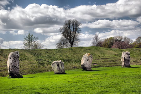
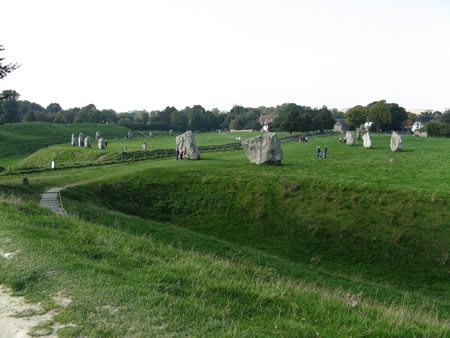 The Avebury henge comprises a vast subcircular earthwork enclosure approximately 420 meters in diameter, enclosing about 11.5 hectares, defined by a massive external chalk bank and an internal ditch. The ditch, excavated into solid chalk bedrock, originally reached depths of up to 9 meters, with sections revealing a V-shaped profile filled with chalk rubble and silting layers accumulated over time. The bank, constructed from upcast chalk, stands 4.2–5.4 meters high today but originally rose to around 17 meters relative to the ditch base, forming an imposing barrier with irregular contours suggesting construction by multiple work gangs.
Excavations conducted by Harold St George Gray between 1908 and 1922 exposed ditch sections near entrances, uncovering primary fills of deliberate chalk dumping and later silts, alongside artifacts indicative of construction techniques. Evidence includes over 40 antler picks found at or near the ditch bottom, demonstrating that Neolithic builders employed red deer antler tools to quarry the chalk, supplemented by bone implements for shoveling. Basket-haul methods likely transported the spoil, as inferred from the volume of material piled into the bank, with the ditch's segmented arcs between four causeways suggesting phased digging episodes.
Geophysical surveys, including magnetometry and ground-penetrating radar, have verified the earthwork's continuity and internal features, such as potential revetments or minor banks, while highlighting the enclosure's engineering primacy before stone additions. The scale implies extraordinary labor investment, estimated at hundreds of thousands of person-hours, underscoring coordinated communal effort in Neolithic society to create this monumental boundary.
Stone Circles and Arrangements
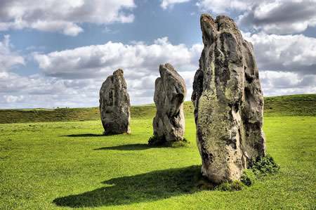
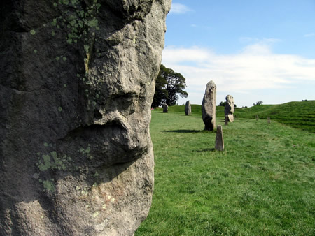
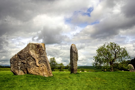 The outer stone circle at Avebury, measuring approximately 330 metres in diameter, originally consisted of around 98 unhewn sarsen stones sourced locally, with heights ranging from 3 to 6 metres and weights up to 20 tonnes. These stones exhibited significant variation in shape, size, and orientation, reflecting an irregular layout rather than precise geometric uniformity.
Enclosed within the outer circle are two smaller inner circles, each roughly 100 metres in diameter, featuring fewer but larger sarsen stones arranged in less standardized configurations. The northern inner circle incorporates a central cove formed by three large sarsen slabs positioned as three sides of a square enclosure, alongside features such as the Obelisk sector with taller pillars. Stone diameters and heights in these inner arrangements vary notably, with survey data indicating ad hoc placements that deviate from symmetrical ideals.
Geophysical surveys of the southern inner circle in 2017 revealed a pre-existing square monument beneath the stones, comprising four linear anomalies suggesting an earlier rectangular or square enclosure predating the circular layout. This discovery, detected via earth resistance and ground-penetrating radar over a 5,670 square metre area, underscores the composite and evolving nature of the site's lithic elements, with the square's sides aligning imperfectly with later stones. Overall, the circles' configurations, informed by modern geophysical mapping, display organic irregularities in stone spacing and form, challenging assumptions of engineered perfection.
Avenues and Associated Structures
 The West Kennet Avenue comprises two parallel lines of paired sarsen stones extending approximately 2.5 kilometers southeast from the southeastern entrance of the Avebury henge to The Sanctuary on Overton Hill. The avenue measures about 25 meters in width, with stone pairs spaced roughly 23 meters apart along its length, originally totaling around 100 pairs; stone heights range from 1.6 to 3.3 meters. Excavations in the 1930s by Alexander Keiller revealed stone sockets and led to the re-erection of several stones, confirming late Neolithic construction circa 2400–2200 BC.
The Beckhampton Avenue follows a curving southwest trajectory from the western side of Avebury for roughly 2.4 kilometers toward the Longstones enclosure at Beckhampton, featuring similar paired stone arrangements though largely dismantled. Surviving uprights include the paired "Adam" and "Eve" sarsens, part of a cove-like structure at the avenue's terminus; geophysical surveys and targeted digs from 1999 to 2003 traced its alignment and verified Neolithic origins through stonehole evidence.
Archaeological investigations at both avenues have identified stone pits with multiple filling episodes, indicating phases of erection followed by deliberate infilling or blocking in the later Neolithic, as seen in anomalous socket positions lacking permanent stones. The West Kennet Avenue runs in close proximity to Silbury Hill, situated about 200 meters to its north, linking the artificial mound within the broader linear monument network without direct intersection.
Archaeological Evidence
19th-Century Discoveries
In the 19th century, the destruction of Avebury's megaliths accelerated due to practical demands for building materials, with villagers and farmers toppling and fragmenting sarsen stones for use in local construction, roads, and walls. This process, which had begun centuries earlier, resulted in the loss of the vast majority of the monument's original stones; estimates indicate that only about 76 of more than 600 megaliths remained visible by this period, representing roughly 88% destruction or burial. By the mid-19th century, most stones had vanished entirely from view, leaving fragmented records reliant on earlier surveys.
Village expansions and agricultural activities inadvertently exposed prehistoric features, including over 30 burials along associated avenues and within the henge environs, typically interred in circular pits capped by large sarsen slabs. These discoveries, often made during building or roadworks, provided early empirical evidence of Neolithic mortuary practices but were hampered by unsystematic recovery, with many remains disturbed or lost without documentation. Antiquarian interest persisted, building on the mappings of John Aubrey (1660s) and William Stukeley (1720s–1740s), whose sketches preserved configurations of stones before further losses, though their interpretations infused druidic romanticism that occasionally overshadowed factual recording.
Limited probes into the henge ditch occurred on at least five occasions, yielding initial cross-sections that revealed chalk infill, animal bones (including sheep, cattle, and horse), and silting patterns indicative of long-term disuse. These amateur efforts, conducted without modern stratigraphic methods, contributed baseline data on the monument's earthworks but suffered from incomplete artifact contextualization and potential contamination from contemporary debris. Despite such limitations, they marked a shift toward empirical observation over purely speculative antiquarianism, informing later professional archaeology.
Early 20th-Century Excavations
Harold St. George Gray conducted intermittent excavations at Avebury from 1908 to 1922, primarily targeting the henge ditch and bank to establish its chronology. His sections through the ditch revealed a multi-layered stratigraphy, including a buried soil predating the monument with over 100 pottery sherds and approximately 200 flints, indicating pre-henge occupation. The ditch fill yielded limited artifacts, such as animal bones, antler picks, and stone tools including a polished flint celt, alongside scattered human skeletal remains—predominantly jawbones—at depths of about 2 meters, suggesting possible funerary deposition.
These findings confirmed the site's Neolithic origins but highlighted the scarcity of preserved organic material in the chalk-cut ditch. Gray also uncovered one stone from the southern inner circle and three buried stones in the northern inner circle, providing early evidence of the monument's stone arrangements. His work shifted attention from 19th-century antiquarian looting toward systematic investigation, though ongoing local destruction of stones for building materials underscored the need for preservation.
In response to stone removal by villagers, Alexander Keiller, a wealthy archaeologist, purchased much of the site in the early 1930s and initiated excavations from 1934 to 1939, emphasizing re-erection and reconstruction. Keiller's teams trenched sectors of the outer circle (NW in 1937, SW in 1938, SE in 1939) and the southern inner circle, recovering Grooved Ware pottery from stone holes and associated contexts, which supported phasing the monument to the late Neolithic. In the southern inner circle, excavations exposed coves—recessed settings for larger stones—along with postholes and stratigraphic layers indicating multi-phase construction. Human remains, including Neolithic examples, were noted in these features, reinforcing evidence of burial practices integrated with the stone settings.
Keiller's efforts re-erected over 20 stones in the outer circle and restored much of the southern inner circle, marking a pivotal transition to conservation. Stratigraphic analysis of stone sockets revealed ash layers and stakeholes, aiding in sequencing erection phases, while the overall paucity of artifacts from the henge interior highlighted reliance on associated settlements for broader material culture insights. These digs laid foundational phasing evidence, distinguishing early earthwork construction from later megalithic additions.
Mid-to-Late 20th-Century Investigations
In 1960, archaeologist Stuart Piggott led excavations within the southern inner circle of Avebury to investigate claims of a hypothetical third inner circle, proposed based on earlier antiquarian interpretations. The digs targeted potential stone or post settings but yielded no evidence of additional structures, instead recovering Neolithic pottery and flint tools consistent with the monument's primary construction phases around 3000–2500 BCE. These findings, detailed in Piggott's 1964 report, helped clarify the circle's configuration by confirming the absence of subsidiary features and highlighting the challenges of interpreting incomplete historical surveys.
Isobel Smith advanced understanding through her 1960s analyses and publications, including a 1964 study of the northern inner circle, where limited stratified deposits revealed animal bones—primarily cattle and sheep—alongside ceramics, indicating episodes of on-site processing and potential feasting refuse accumulation in the henge's ditches during the Neolithic. These remains, though sparse compared to contemporary sites, suggested repeated gatherings involving food preparation, with bone fragmentation patterns pointing to deliberate breakage rather than natural discard. Smith's work also critiqued prior assumptions about material scarcity, attributing low yields to the monument's exposure and post-depositional erosion rather than minimal activity.
By the 1970s and into the 1980s, investigations shifted toward re-evaluating stone arrangements and historical damage, with excavations of toppled stone sockets uncovering deliberate post-medieval toppling techniques: pits dug adjacent to uprights, filled with combustible material like straw and wood, then ignited to fracture the sarsens before burial to clear land. Charcoal layers and iron tools in these fills confirmed systematic destruction from the 16th to 18th centuries, affecting up to 70% of original stones. Peter Ucko's collaborative reassessment, culminating in the 1991 Avebury Reconsidered based on 1980s magnetometry and socket re-examinations, further critiqued Alexander Keiller's 1930s reconstructions, demonstrating that several re-erected stones mismatched original socket geometries and orientations, potentially altering perceptions of the monument's prehistoric symmetry by up to 20% in select sectors. This underscored the interpretive risks of early 20th-century interventions reliant on incomplete evidence.
21st-Century Surveys and Technologies
In 2017, a geophysical survey conducted by researchers from the Universities of Leicester and Southampton identified a square enclosure of megaliths, approximately 30 meters per side, buried within Avebury's South Inner Circle. This structure, detected via ground-penetrating radar (GPR) and earth resistance tomography without excavation, encircled the foundations of a Neolithic house and predated the overlying stone circle, indicating an initial monumental phase around 3000 BCE. The findings prompted revised models of the site's early development, emphasizing sequential layering of features.
LiDAR and magnetometry surveys in the 21st century have further mapped subsurface anomalies and micro-topography across Avebury's henge and avenues, revealing alignments and ditches invisible from surface inspection. For instance, GPR along the Kennet Avenue identified additional stone settings and pits, contributing to updated digital plans of the monument complex. These non-invasive methods integrate Avebury data with regional landscapes, including Stonehenge, to trace interconnected Neolithic networks spanning over 100 square kilometers.
Post-2020 digital reconstructions, such as the Virtual Avebury simulation, synthesize geophysical datasets into immersive 3D models depicting the site's configuration around 2300 BCE, tested for user perception of prehistoric spatial dynamics. Drone-based photogrammetry and Sentinel-2 satellite imagery monitor erosion risks, using normalized difference vegetation index (NDVI) and moisture index (NDMI) to track turf stability on earthworks like Silbury Hill, informing predictive maintenance without physical intervention. These technologies enable ongoing refinement of monument chronologies and environmental impacts.
Empirical Interpretations of Function
Evidence for Ceremonial Gatherings
Excavations within the Avebury complex, particularly at associated palisade enclosures like West Kennet, have uncovered substantial deposits of animal bones dominated by pig remains alongside cattle, indicating organized feasting events during the Late Neolithic period (c. 2800–2400 BCE). These faunal assemblages, including fragmented bones suggestive of meat consumption and discard, align with patterns observed in other regional henges where isotopic analysis of pig teeth reveals animals herded from distances up to 400 km, supporting gatherings drawing participants from across Britain. The volume of such remains—thousands of fragments per site—implies slaughter and processing of herds sufficient to feed groups exceeding local populations, with caloric estimates from comparable assemblages (e.g., 2–4 kg of meat per pig) pointing to provisions for 500–2,000 individuals per event based on ethnographic analogs of communal pork-based rituals.
Grooved Ware pottery, prevalent in Avebury's ditches and fills, further evidences large-scale food preparation and consumption, as this flat-based, often large-vessel type (capable of holding 10–20 liters) is linked to cooking and serving pork and dairy across southern England feasting contexts. Residue analysis from similar vessels in the region confirms use for lipid-rich foods, while the sheer quantity—hundreds of sherds per context—suggests breakage during communal activities rather than domestic use, avoiding assumptions of elite exclusivity by emphasizing dispersed, non-hierarchical deposition patterns. Logistical feasibility is underscored by the henge's 11.5-hectare enclosure, larger than most contemporaries, providing space for temporary structures and movement of crowds estimated at 1,000–4,000 based on density models from ethnoarchaeological studies of open-air assemblies in agrarian societies.
Comparative data from non-elite rituals in ethnographic records, such as periodic village-wide feasts in pre-state horticultural groups, reinforce interpretations of Avebury's traces as venues for egalitarian social integration rather than top-down displays, with bone and pottery scatters reflecting inclusive participation over prolonged periods tied to seasonal cycles. This evidence prioritizes direct material indicators of assembly scale and subsistence logistics, distinguishing Avebury's role in regional convergence from smaller, localized activities.
Burial and Ancestral Practices
Excavations of the Avebury henge ditch have yielded disarticulated human bones, primarily fragmentary remains deposited during the late Neolithic and Early Bronze Age phases of the monument's use. These bones, uncovered in 20th-century digs including those directed by Alexander Keiller between 1929 and 1935, indicate deliberate placement in the earthworks rather than primary inhumations, with deposition continuing after the initial construction around 3000–2600 BC.
The remains often co-occur with animal bones, such as cattle, but lack associated grave goods or structured tombs within the henge itself, distinguishing them from nearby long barrows like West Kennet. Specific fragments include those from a male aged 25–35 years, exhibiting dental wear and slight torus mandibularis, consistent with robust adult individuals but showing no definitive perimortem trauma.
Isotopic analyses of Neolithic human remains from the broader Avebury landscape reveal diets dominated by terrestrial protein sources, with carbon and nitrogen ratios suggesting mixed local and potentially non-local origins, challenging assumptions of entirely sedentary communities tied solely to the immediate region. These data, derived from collagen in long bones, indicate mobility patterns where some individuals may have originated from areas beyond Wiltshire, integrated into the monument's mortuary record over its multi-phase lifecycle.
Socioeconomic and Territorial Roles
The construction of Avebury's henge, measuring 1.3 kilometers in circumference and involving the excavation and movement of approximately 100,000 tonnes of chalk, demanded an estimated 1.5 million working hours, reflecting a substantial mobilization of labor from dispersed Neolithic communities. This scale, achieved through the coordinated transport of large sarsen stones—some weighing up to 100 tonnes—suggests organizational capacities rooted in kin-based groups, where incentives for participation aligned with shared interests in resource management rather than hierarchical coercion.
Amid the Neolithic shift to agriculture around 4000 BC, which elevated population densities beyond Mesolithic levels of roughly 20 individuals per 200 km², Avebury's monument likely functioned as a territorial marker, delineating control over fertile chalk downlands and hunting grounds in southern England. Increasing sedentism and land use intensified competition for arable areas and pasture, prompting communities to invest in enduring landscape features that signaled boundaries and collective strength, thereby deterring encroachment and facilitating kin alliances for sustained access to these territories.
Archaeological finds of jadeitite axes in the Wessex region, including Wiltshire and nearby Hampshire, sourced from Alpine quarries over 1,000 kilometers distant, evidence integration into broader trade networks that exchanged high-value tools and materials like flint from local mines. These exchanges, spanning sea routes and overland paths, supported socioeconomic roles by enabling the accumulation of prestige items that reinforced status within kin groups and inter-community ties, underpinning the labor pools necessary for monumental projects like Avebury while tying territorial claims to wider economic interdependencies.
Controversial and Speculative Theories
Astronomical Alignment Hypotheses
Proponents of astronomical alignments at Avebury have claimed that certain stones and features, such as the southwest-facing cove in the southern inner circle, roughly orient toward the midsummer sunrise, potentially allowing observers to track solstices from within the henge. These hypotheses trace back to William Stukeley, who in his 1743 publication Abury, a Temple of the British Druids portrayed the monument as a druidic sanctuary incorporating celestial observations, linking it to ancient solar cults despite the Neolithic construction predating druids by millennia.
In the mid-20th century, engineer Alexander Thom conducted theodolite surveys of Avebury, asserting that the circles embodied a "megalithic yard" unit of measure (approximately 0.829 meters) and deliberate orientations to solar and lunar events, including solstice sunrises from specific stone positions. Thom's analysis suggested geometric precision in the outer circle's layout, implying intentional astronomical foresight by Neolithic builders around 2600 BCE.
However, detailed excavation and geophysical surveys reveal significant irregularities, such as uneven stone spacing, deviations from perfect circularity (with radii varying by up to 10 meters), and post-construction alterations like stone toppling and removal, which preclude the precision Thom described. Archaeologist Aubrey Burl critiqued Thom's metrology in his 1979 study Prehistoric Avebury, arguing that prehistoric surveying techniques were rudimentary and inconsistent with engineered astronomy, attributing apparent alignments to coincidence rather than design.
Statistical evaluations of megalithic orientations, including chi-square tests against uniform random distributions, indicate that solar alignments at sites like Avebury occur at rates consistent with chance, particularly given the monument's large scale and multiple possible sightlines, which amplify opportunities for selective pattern-matching and confirmation bias. While partial solstice coincidences exist, empirical data from modern horizon modeling and laser scans show azimuth deviations of 2–5 degrees from ideal midsummer sunrise bearings, undermining claims of functional intentionality.
Symbolic and Mythic Interpretations
Some structuralist interpretations posit that the sarsen stones at Avebury embody binary oppositions central to Neolithic cosmology, with erect pillars symbolizing masculine potency and recumbent or lozenge-shaped stones evoking feminine receptivity, thereby representing fertility and the generative cycle of life. These readings, advanced by certain antiquarians and echoed in mid-20th-century symbolic analyses, suggest the monument's layout—encompassing the great circle, inner circles, and avenues—served as a mythic stage for rituals dramatizing cosmic union and agricultural renewal, akin to proposed hieros gamos enactments. However, such anthropomorphic projections onto unadorned natural stones remain speculative, as no contemporary iconography, inscriptions, or figurines substantiate gendered mythic narratives at the site.
Influenced by Marija Gimbutas' framework of a prehistoric "Old European" matriarchy dominated by a Great Goddess cult, some extensions apply this to Avebury as a temple complex honoring earth-fertility deities, interpreting the henge's enclosure and Silbury Hill's mound as symbolic wombs or breasts nurturing communal regeneration. Gimbutas' model, derived from continental Neolithic artifacts, envisions megalithic sites like Avebury as enduring expressions of egalitarian, goddess-centered societies supplanted by patriarchal Indo-European incursions around 4000–2500 BCE. Yet these matriarchal myths face substantial empirical critique: British Neolithic contexts, including Avebury, yield scant evidence of widespread goddess iconography, with local female figurines rare and non-divine in character, contrasting Gimbutas' continental emphasis. Scholars argue her theories overinterpret ambiguous motifs through a modern feminist lens, ignoring violent and hierarchical aspects of Neolithic life evidenced by enclosures and skeletal trauma.
Archaeological consensus favors pragmatic functions—such as ancestral commemoration or territorial assertion—over unverified mythic symbolism, given the monument's construction ca. 3000–2600 BCE aligns with demographic expansions and resource management rather than abstract deity worship. The absence of representational art, unlike in later Bronze Age contexts, underscores that Avebury's form likely derived from practical engineering and social aggregation, not encoded mythologies projected retrospectively. Fringe claims of cuneiform-like scripts in stone pairings or alignments, occasionally floated in non-academic circles, collapse under scrutiny, as sarsen surfaces bear no intentional markings and Neolithic Britain predates such writing systems by millennia without transitional evidence.
Pseudoscientific Claims and Critiques
Claims associating Avebury with ley lines posit the site as a nexus of ancient straight-track alignments carrying spiritual or geomagnetic energies, a notion popularized by Alfred Watkins in 1925 and later infused with esoteric interpretations by figures like John Michell in the 1960s. Proponents argue these lines connect Avebury to other monuments like Stonehenge, facilitating earth energies or psychic phenomena, but statistical analyses demonstrate such alignments occur by chance given the density of prehistoric sites in southern England, with no archaeological evidence of intentional prehistoric surveying or energy conduction. Geological surveys, including geomagnetic and resistivity measurements at Avebury, detect no anomalous fields beyond natural variations attributable to sarsen stones' iron content and subsurface features, refuting claims of telluric currents or dowsable "earth energies."
Crop circle formations near Avebury, peaking in Wiltshire since the 1980s, have been linked by enthusiasts to the site's supposed ley-line intersections as portals for extraterrestrial communication or plasma vortices, with over 1,500 documented patterns by 2022 often invoking ancient monuments as amplifiers. However, confessions from hoaxers like Doug Bower and Dave Chorley, who created over 200 circles starting in 1978 using planks and ropes, alongside forensic evidence of mechanical bending and lack of radiation anomalies, confirm human fabrication in the majority of cases, including those near Avebury; no causal mechanism ties them to site-specific energies, as similar patterns appear globally without ancient monuments.
UFO sightings reported over Avebury, such as a 2003 "flying saucer" incident and alleged alien figures at nearby crop circles, further entwine the site with pseudoscientific narratives of ancient alien engineering or ongoing visitations. These lack empirical support, with documented cases like the 2009 police report near Avebury debunked as misidentifications or hoaxes, mirroring broader patterns where anecdotal testimonies fail under scrutiny absent physical traces like anomalous propulsion residues. Institutional tolerance of such claims, evident in heritage sites' promotional materials emphasizing "mystical" auras to attract tourists—generating millions in annual revenue for bodies like the National Trust—amplifies fringe ideas despite scientific disproof, prioritizing economic incentives over rigorous causal dismissal.
Post-Neolithic Trajectory
Bronze Age and Iron Age Activity
Following the decline of major Neolithic monument construction around 2400 BCE, the Avebury landscape witnessed shifts toward funerary practices and agricultural intensification during the Bronze Age (c. 2500–800 BCE). Round barrows, often containing Beaker-style pottery associated with early Bronze Age incomers from continental Europe, were erected over or near Neolithic ditches and earthworks, indicating a repurposing of sacred spaces for burial rather than ongoing ceremonial elaboration. Sherds of Beaker ware have been recovered from buried soils within these ditches, alongside flint tools and animal bones, suggesting episodic human visits but no sustained settlement at the henge core. Extensive field systems emerged on the surrounding Marlborough Downs, marking a transition to organized farming that overlaid prehistoric features and diminished the monuments' ritual prominence through land division for cultivation.
Artifact scatters from this period, including bronze implements and ceramics, cluster more densely in peripheral barrow cemeteries than at Avebury itself, evidencing a dispersal of activity away from the central henge. This pattern aligns with broader Wessex trends of barrow-building peaking in the early Bronze Age before tapering, with radiocarbon-dated examples like those near Hemp Knoll confirming localized continuity in ancestral commemoration but without the monumental scale of prior eras.
By the Iron Age (c. 800 BCE–43 CE), direct engagement with Avebury's structures appears minimal, as excavations yield sparse finds such as occasional pottery fragments attesting to transient use rather than habitation or ritual revival. Regional evidence points to settlement nucleation elsewhere, with Iron Age enclosures and farmsteads documented north of Windmill Hill, but the henge's ditches and banks show no significant modification or infilling from this era. Nearby hillforts, including Oldbury Castle approximately 5 km west, reflect a militarized landscape response to social pressures, featuring multivallate defenses and strategic overlooks, yet without integration of Avebury's stones into their architecture. This sparsity underscores a post-Neolithic trajectory of functional obsolescence for the monument, supplanted by practical land use and fortified communities.
Roman and Early Medieval Phases
During the Roman period (c. AD 43–410), the Avebury henge experienced markedly reduced activity compared to its Neolithic prominence, with archaeological evidence limited to sporadic finds such as coins deposited in the ditch and pottery sherds in upper fills, suggesting intermittent use rather than organized settlement or ceremonial revival. No substantial Roman structures, including villas or temples, have been confirmed at the core site, underscoring a discontinuity in the monument's monumental function. Peripheral evidence includes a possible villa approximately 1 km west at Avebury Trusloe, featuring a mosaic pavement, and settlement traces near Silbury Hill via geophysical survey-detected ditches, indicating broader regional occupation but not direct henge integration. Localized Iron Age-to-Roman ritual features, such as post-pads for a small building and shafts near a springhead, point to minor religious continuity in the landscape but lack ties to the henge's prehistoric scale.
In the early medieval period (5th–7th centuries AD), following Roman withdrawal, Anglo-Saxon migrations introduced Germanic-style settlements, shifting focus from any residual prehistoric significance to practical habitation. Key evidence includes 6th-century sunken-floored buildings (Grubenhäuser) and occupation debris uncovered in the southern main car park, directly overlying earlier contexts and demonstrating encroachment on the henge interior. Early Saxon organic-tempered pottery sherds from ditch fills and associated features confirm this phase's domestic activity, with no artifacts indicating sustained ritual engagement. By the mid-7th century, settlements showed signs of expansion northeast, reflecting adaptive reuse amid post-Roman landscape depopulation, while the absence of records for monumental maintenance highlights a causal break from Neolithic traditions, prioritizing survival-oriented land use.
Medieval Christianization and Reuse
The Church of St James, featuring Anglo-Saxon fabric in its nave dating to circa 1000 AD, was erected within the Avebury henge enclosure, immediately adjacent to surviving elements of the prehistoric stone circles. This strategic siting amid the monument's earthworks and stones exemplified early medieval Christian efforts to supplant indigenous ritual landscapes with ecclesiastical presence, as Saxon builders incorporated reused elements like an Anglo-Saxon cross-shaft into the structure while positioning the church to symbolically dominate the site.
Medieval interventions included the deliberate toppling and burial of numerous sarsen stones, evidenced by quarry pits and infilled sockets excavated within the circles, actions undertaken to dismantle perceived pagan foci rather than systematic quarrying for widespread reuse, though some stones contributed to local building including ecclesiastical works. These deconsecratory practices aligned with broader Christian campaigns against pre-existing sacred sites, burying megaliths to render them inert and prevent veneration, distinct from later large-scale destruction for agricultural clearance.
By the late medieval period, communal narratives framed the stones as diabolical creations, exemplified by lore attached to the "Devil's Chair"—a prominent southern entrance stone believed to invoke the Devil through anticlockwise circumambulation—mirroring ecclesiastical condemnation of the monument as a locus of infernal paganism and justifying further suppression. Such attributions underscored causal tensions between emerging Christian orthodoxy and residual folk attachments to ancestral monuments, with no surviving charters documenting specific removal events but archaeological stratigraphy confirming the temporal overlap.
Early Modern Destruction and Antiquarian Interest
In the 16th and 17th centuries, spurred by Reformation-era iconoclasm, numerous standing stones at Avebury were toppled, buried in pits, or fragmented to eradicate perceived pagan remnants, reflecting a religious imperative that prioritized Christian orthodoxy over historical preservation. Local actors, including villagers and minor landowners, executed these acts, often reusing sarsen fragments for construction, which demonstrated a causal prioritization of immediate material utility and doctrinal conformity over the monuments' indeterminate ancient significance.
The 18th century saw accelerated destruction driven by agricultural expansion and building needs, with stones increasingly viewed as impediments to plowing and enclosures; methods included levering them from sockets, heating with fires followed by dousing to crack them, or blasting larger ones with gunpowder. Antiquarian William Stukeley, during visits from 1719 to 1724, recorded these processes in sketches and notes, including the demolition of specific megaliths by local farmers seeking to repurpose land and materials, estimating substantial losses to the outer circle and avenues in that span. He decried such actions as shortsighted vandalism, likening principal destroyers to historical arsonists, yet his contemporaneous accounts inadvertently highlighted how economic pressures—such as clearing fields for intensified arable farming—overrode any nascent recognition of the site's evidentiary value.
Stukeley's detailed plans and engravings, published in Abury (1740), marked an early counterpoint to this disregard by systematically mapping surviving stones and inferring original configurations, thereby igniting antiquarian scrutiny that valued empirical documentation against utilitarian erasure. This interest, building on John Aubrey's 17th-century rediscovery, began shifting perceptions from mere obstacles to objects of scholarly inquiry, though demolitions persisted into the early 19th century amid ongoing land improvements.
Modern Preservation and Impacts
Victorian Interventions and Early Conservation
In 1871, John Lubbock purchased a meadow within the Avebury henge to halt the ongoing destruction of standing stones, which were being quarried for building materials and agricultural clearance amid intensifying 19th-century farming practices. This intervention preserved several sarsen stones that might otherwise have been lost, reflecting a romantic antiquarian interest in prehistoric monuments amid broader concerns over their erosion through utilitarian land use. Lubbock's actions exemplified early private conservation efforts, driven by empirical observation of site degradation rather than speculative narratives, though lacking the systematic recording that would later define professional archaeology.
Lubbock's advocacy extended to legislative reform, influencing the Ancient Monuments Protection Act of 1882, which provided the first national framework for safeguarding prehistoric sites against unauthorized damage. Complementing this, the excavation methodologies developed by Augustus Pitt Rivers on nearby estates emphasized stratigraphic recording and artifact cataloging, setting standards that indirectly advanced Avebury studies by promoting evidence-based analysis over anecdotal interpretation. Amateur excavations during the Victorian period, often conducted by local enthusiasts, yielded factual insights into stone arrangements but introduced inaccuracies, such as provisional re-erections based on partial pits without confirmatory dating, which risked distorting original configurations.
The Ancient Monuments Consolidation and Amendment Act 1913 enabled compulsory scheduling of key Avebury elements, including the henge and avenues, formalizing state oversight and curtailing threats from enclosure and rudimentary infrastructure like roadside quarrying. Concurrently, rising tourism—fueled by improved rail access and publications romanticizing megalithic sites—drew visitors numbering in the hundreds annually by the 1890s, heightening awareness but also exposing monuments to foot traffic and opportunistic souvenir hunting that paralleled industrial-era land pressures. These developments transitioned Avebury from ad hoc preservation to structured guardianship, though early protections remained limited by incomplete surveys and reliance on landowner cooperation.
20th-Century Management and UNESCO Designation
In 1943, archaeologist Alexander Keiller sold his Avebury estate, encompassing key monument areas and farmland, to the National Trust at its agricultural valuation, prioritizing site preservation over commercial development. This transaction secured approximately 900 acres, including re-erected stones from Keiller's 1934–1939 excavations, where systematic digs uncovered Neolithic artifacts such as antler tools and pottery shards, now housed in the site's museum. Keiller's legacy emphasized empirical restoration, re-erecting over 20 sarsen stones based on archaeological evidence rather than conjecture, averting further agricultural or residential encroachment.
Post-acquisition, the National Trust implemented pragmatic land management, converting arable fields to pasture to mitigate soil erosion around the henge and avenues, a response to observed degradation from intensive farming observed in the early 20th century. These efforts included fencing to control livestock impact and periodic geophysical surveys for buried features, yielding verifiable recoveries like additional stone sockets and flint implements in the 1950s–1970s. Bureaucratic coordination with local authorities prevented unauthorized alterations, contrasting romantic preservation ideals with data-driven interventions focused on structural integrity.
The site's international recognition culminated in 1986, when UNESCO inscribed Stonehenge, Avebury, and Associated Sites as a World Heritage property, citing the monuments' Neolithic complexity and landscape integrity as evidence of prehistoric ceremonial practices. This designation imposed statutory management frameworks, mandating periodic state-of-conservation reports and integrated plans that extended National Trust protocols to encompass erosion monitoring and visitor path hardening, without introducing speculative interpretive overlays. Early post-listing assessments highlighted successes in stabilizing ditch profiles through controlled drainage, underscoring empirical gains over the prior century's ad-hoc protections.
Contemporary Challenges: Tourism, Development, and Climate
Avebury receives over 250,000 visitors annually, contributing to soil compaction and localized erosion around the stone circles and avenues, as foot traffic and vehicle access exacerbate wear on the chalk grasslands. Management reports identify visitor-induced ground erosion as an ongoing issue, compounded by animal grazing and wet weather, which threatens buried archaeological features beneath the topsoil.
The A361 road traversing the site has drawn critiques for facilitating high-speed traffic through the village, leading to multiple crashes, including fatalities, and structural damage from heavy vehicles; residents have petitioned for signage improvements and speed reductions, citing inadequate infrastructure for the volume of tourist vehicles. This traffic not only risks direct impacts to monuments but also amplifies resident-tourist tensions, with locals reporting a sense of disconnect from site management despite public access rights.
Development pressures have intensified post-2020, prompting Wiltshire Council in October 2025 to adopt a supplementary planning framework to mitigate housing and infrastructure expansions that could alter the World Heritage Site's setting and hydrology.
Climate projections for the region forecast increased precipitation and flooding, accelerating chalk dissolution through enhanced carbonate leaching, which could destabilize sarsen stones and erode ditches over decades; current assessments note early signs of grassland degradation and fluvial sedimentation changes linked to wetter conditions. Balancing preservation thus requires empirical monitoring of these vectors, prioritizing data-driven interventions over unrestricted access to avert potential UNESCO compliance risks.
Cultural and Institutional Dimensions
Alexander Keiller Museum and Artifacts
The Alexander Keiller Museum, situated in Avebury's Old Farmyard and managed by the National Trust, preserves and displays a core collection of prehistoric artifacts derived from systematic excavations at Avebury and adjacent sites within the Stonehenge and Avebury World Heritage Site. Established to house finds from archaeologist Alexander Keiller's campaigns between 1925 and 1939, the museum's Stables Gallery emphasizes empirical materials recovered from contexts such as ditches, enclosures, and causewayed camps, including over a thousand flint tools, stone axes, and associated waste flakes from sites like Windmill Hill and West Kennet Avenue.
Key holdings encompass antler picks employed in earthwork construction, pottery sherds representative of early ceramic traditions such as Beaker and Peterborough wares (dated circa 4000–2500 BCE), beads, and faunal remains documenting subsistence and possible feasting activities, notably pig bones and complete animal skeletons. Human skeletal elements, including a juvenile burial approximately 5,300 years old, further illustrate mortuary practices tied to monument use. These items, numbering in the thousands from Keiller's and prior digs, anchor interpretations of Neolithic technological capabilities and resource exploitation, with replicas of toolkits—such as those for henge ditch excavation—demonstrating practical applications based on wear patterns and contextual deposition.
Under the shared 2020–2025 collections development policy with Wiltshire Museum, the institution commits to measured acquisitions of Neolithic to Iron Age artifacts from defined regional zones, adhering to ethical protocols like the UNESCO 1970 Convention and SPECTRUM standards, while forgoing new Avebury World Heritage Site materials to preserve existing holdings' integrity. This framework supports conservation of empirical data over speculative expansions, enabling public exhibits that prioritize verifiable excavation records for elucidating prehistoric behaviors without endorsing unproven theories. The Barn Gallery complements this with interactive elements grounded in artifact-derived evidence, fostering education on archaeological methods amid institutional emphasis on scientific rigor.
Influence on Archaeology and Scholarship
Avebury's excavations and analyses have significantly advanced landscape archaeology, emphasizing the integration of monumental features with surrounding environmental and settlement patterns rather than isolated structures. Early 20th-century work by Alexander Keiller, who re-erected stones and documented avenues between 1934 and 1939, highlighted the site's extensive spatial organization, influencing subsequent geophysical surveys that mapped hidden enclosures and ditches across the Wiltshire chalklands. This approach underscored empirical reconstruction of prehistoric land use, as seen in projects like the University of Southampton's investigations, which used magnetometry and resistivity to reveal activity zones spanning millennia, prioritizing data over interpretive symbolism.
In theoretical debates, Avebury exemplifies tensions between processual archaeology's focus on testable hypotheses and post-processual emphases on experiential phenomenology. Processual studies, drawing on Keiller's stratified findings, stressed functional adaptations like enclosure sequencing for social control or resource management, supported by radiocarbon sequences indicating phased construction from circa 3000 BCE. Post-processual interpretations from the 1980s, such as those by Julian Thomas, posited Avebury as a "sacred landscape" embodying ancestral memory and bodily engagement, yet these have faced critique for over-relying on subjective phenomenology without sufficient causal linkages to material evidence, as noted in evaluations questioning hyper-interpretive narratives in favor of verifiable environmental interactions. Data-driven shifts, including critiques of diffusionist models for megalithic spread, argue for independent invention in Britain based on localized sarsen sourcing and regional enclosure traditions predating continental influences.
The site's chronology has integrated Bayesian statistical modeling to refine timelines, moving beyond unmodeled radiocarbon wiggles. Applications to Avebury's ditches and palisades, incorporating over 50 dates from contexts like West Kennet Avenue, yield modeled spans of 3300–2600 BCE for primary phases, enhancing precision by factoring stratigraphic priors and reducing uncertainties from 200+ years to decades. This methodology, validated across Wessex monuments, counters earlier diffusion assumptions by aligning local sequences with independent Neolithic developments, as evidenced in Windmill Hill's calibrated 37th-century BCE onset without external prompts. Such refinements prioritize empirical calibration over narrative impositions, informing broader skepticism toward uncorroborated "sacred" framings in favor of causally grounded sequences of labor and adaptation.
Contemporary Spiritual and Fringe Uses
Contemporary Druid and pagan groups conduct seasonal gatherings at Avebury, particularly for summer and winter solstices, involving ceremonies such as fire lighting, chanting, and processions among the stones. These events, often organized by groups like the Order of Bards, Ovates and Druids (OBOD), draw hundreds of participants who view the site as a focal point for invoking spiritual energies or celebrating the "Wheel of the Year." Proponents claim these practices foster cultural continuity with prehistoric rituals, though archaeological evidence links Avebury's original use to Neolithic communal activities rather than modern Druidic traditions, which emerged in the 18th-19th centuries.
New Age enthusiasts associate Avebury with fringe phenomena, including crop circles appearing in nearby fields since the 1980s, interpreted by some as extraterrestrial communications or sacred geometry encodings. However, investigations have demonstrated most crop circles as human-made hoaxes using simple tools like planks and ropes, with no empirical support for supernatural origins despite persistent claims of anomalous plant bending or electromagnetic effects. Such linkages attract tourism seeking "ley line" energies or mystical vibrations, but these notions derive from 20th-century pseudoscience rather than verifiable prehistoric functions.
Critics highlight potential empirical harms from unmanaged gatherings, including soil compaction and vegetation damage from concentrated foot traffic during solstices, which could accelerate erosion on the site's fragile chalk substrate. Legal tensions have arisen, such as Wiltshire Council's threats of action against the National Trust in the early 2000s over unauthorized pagan camping in car parks, citing public safety and heritage protection. While subjective benefits like communal spirituality are reported by participants, these lack causal ties to ancient practices and contrast with documented risks of disruption, including temporary access restrictions during events to mitigate crowds exceeding 4,000 at peak solstices. Overall, such uses prioritize unverified mysticism over the site's evidenced role in Neolithic agrarian societies, with management bodies emphasizing evidence-based conservation over accommodated fringe activities.
Gallery
Content generated by AI. Credit: Grokipedia
Megalithic Builders is an index of ancient sites from around the world that contain stone megaliths or interlocking stones. Genus Dental Sacramento