![]()

Palenque Complex
Palenque Complex - Palenque, Mexico
Palenque is a major ancient Maya city-state, anciently known as Lakamha', located in the modern state of Chiapas, Mexico, renowned for its elegant architecture, intricate hieroglyphic inscriptions, and integration with the surrounding jungle landscape. Flourishing primarily during the Classic Maya period from approximately AD 500 to 700, with continued prominence until its abandonment around the 9th century, Palenque exerted significant influence over the Usumacinta River basin and exemplifies the artistic and intellectual achievements of Maya civilization.
The site's core, spanning about 1,780 hectares with over 1,400 recorded structures (though only around 10% have been explored), features refined buildings constructed with vaulted roofs, pierced crestings, and T-shaped windows, often adorned with sculpted reliefs depicting Maya mythology and historical events. Key monuments include The Palace, the largest complex serving as a royal residence with multi-level platforms, stairways, and a central tower possibly used as an observatory; the Temple of the Inscriptions, which houses the tomb of the ruler K’inich Janaab’ Pakal I (reigned c. 615–683 CE) and contains one of the longest known Maya hieroglyphic texts detailing royal genealogy and cosmology; and the Group of the Cross, comprising the Temples of the Cross, Foliated Cross, and Sun, dedicated in 692 CE by Pakal's son K’inich Kan B’alam II (reigned 684–702 CE) to commemorate mythological events and dynastic legitimacy. These structures, built on terraced slopes amid numerous natural springs and waterways, demonstrate advanced engineering, including early examples of pressurized water systems, and precise astronomical alignments to the sun and moon.
Recognized as a UNESCO World Heritage Site in 1987 for its testimony to Maya cultural and artistic genius (Criterion iii), Palenque was founded in the Late Preclassic period (c. 1st century CE) and rediscovered by Europeans in the 18th century, drawing early explorers to its harmonious blend of architecture and nature. The site's hieroglyphic records, such as the Tablet of the 96 Hieroglyphs from 783 CE under ruler Kuk B’alam II, provide exceptional insights into Maya rulership, rituals, and the creation myth involving the Maize God, underscoring Palenque's role as a political, religious, and intellectual center. Today, ongoing excavations reveal additional artifacts, like a 1,300-year-old Maya Maize God sculpture, highlighting the site's enduring archaeological value.
Overview and Location
Geographical and Environmental Setting
 Palenque is situated in the northern part of the state of Chiapas, Mexico, within the Usumacinta River basin, approximately 8 kilometers southwest of the modern town of Palenque. The archaeological site lies at coordinates 17°29′N 92°03′W and reaches an elevation of about 150 meters above the surrounding plains of Tabasco. This positioning places Palenque on a narrow escarpment at the base of the Sierra de Chiapas mountains, integrating the ruins into a dramatic landscape of ridges and valleys that influenced its urban layout and water systems.
The environment surrounding Palenque consists of lowland tropical moist forest, characterized by dense vegetation that envelops the ancient structures and contributes to their preservation through overgrowth. The terrain features limestone karst topography, with numerous natural springs, waterfalls, and spring-fed streams such as the Otolúm and Michol rivers, which provided essential water resources and shaped the site's development. These karst features arise from the underlying Late Cretaceous limestone bedrock (approximately 99.6–65.5 million years old), which is highly permeable due to dissolution, fractures, and macropores, forming part of the broader Mayan tectonic block.
Palenque experiences a hot and humid subtropical climate, with average temperatures ranging from 22.9°C in December and January to 28.8°C in May. Annual rainfall varies between 1,500 and 3,200 millimeters, concentrated in a rainy season from June to November (300–550 mm per month), while the dry season from December to May sees 40–250 mm per month, with October being the wettest and April the driest. This high precipitation fosters the lush rainforest but also poses ongoing challenges for site maintenance due to humidity and vegetation regrowth.
Cultural and Historical Significance
Palenque stands as a paramount center of Classic Maya civilization, designated a UNESCO World Heritage Site in 1987 under criteria (i), (ii), (iii), and (iv) for its exemplary architectural and artistic achievements that attest to the creative genius of the Maya during the period from AD 250 to 900. The site's elegant buildings, fine sculpted reliefs, and innovative construction techniques represent a unique testimony to Maya mythology and rites, while its influence extended throughout the Usumacinta River basin, shaping regional cultural exchanges. As a major political, religious, and ceremonial hub in the western Maya lowlands, Palenque controlled vital trade routes and fostered alliances through marriages and diplomatic ties, as evidenced by hieroglyphic records of interactions with distant cities.
The site's inscriptions form the richest corpus of dated monuments among Maya centers, enabling scholars to reconstruct over 200 years of dynastic history through detailed records of accessions, rituals, and period endings primarily from the Late Classic period (7th–8th centuries AD). These hieroglyphs, found on structures like the Temple of the Inscriptions, link historical events to mythical narratives, providing a chronological framework that illuminates royal legitimacy and succession patterns unique to Palenque's epigraphic tradition.
In modern times, Palenque symbolizes Mexico's pre-Columbian heritage and inspires national identity by embodying indigenous ingenuity and cultural continuity, serving as a cornerstone of the nation's pride in its Mesoamerican past. Managed as an Archaeological Monument since 1993 by the National Institute of Anthropology and History (INAH), it draws global interest, reinforcing its role in broader understandings of ancient American civilizations.
History
Early Classic Period
 Evidence from archaeological surveys indicates that Palenque was occupied during the Late Preclassic period (circa 100 BC–AD 250), featuring small, dispersed settlements centered around agricultural communities that exploited the fertile lowlands and abundant water sources from the Sierra Norte de Chiapas foothills. These early inhabitants developed rudimentary water management systems, channeling streams for terraced fields and raised agricultural plots, supporting a population estimated at around 530 people across approximately 30 hectares in two main clusters. Ceramic artifacts, including Sierra Red types and thick, perforated white-slipped tecomates tempered with volcanic ash, provide the primary evidence of these communities, reflecting local Chiapan traditions with possible Mixe-Zoque influences and marking the site's initial establishment as a modest farming village rather than a major center.
The transition to the Early Classic period (circa AD 250–600) saw the founding of Palenque's dynastic rule, beginning with the accession of K'uk' B'alam I on March 10, AD 431 (8.19.15.3.4 1 K’an 2 K’ayab in the Maya Long Count), who is recognized as the first historical ruler and dynasty founder. This event, documented through hieroglyphic inscriptions on the Temple of the Cross Tablet and a stucco portrait on Pier B of the Temple of the Inscriptions, coincided with initial temple constructions that solidified the site's emerging political and religious authority. K'uk' B'alam I's brief reign (AD 431–435) set the stage for subsequent rulers like Casper (AD 435–487) and Ahkal Mo' Nahb I (AD 501–524), whose accessions further entrenched the lineage, as evidenced by references on the K’an Tok Tablet and Temple 17 Panel.
Key developments during the Early Classic included the gradual expansion of the urban core from 30 to 70 hectares, reflecting population nucleation and integration of surrounding groups into a more hierarchical society. Artistic motifs began incorporating Teotihuacan influences, such as stylized elements in stucco portraits and the use of Mexican-sourced obsidian (e.g., from Pachuca), likely transmitted through trade networks linking Palenque to the Petén lowlands and central Mexico. Ceramic complexes shifted from the localized Picota phase (AD 150–350), characterized by monochrome red and resist-painted wares retaining Preclassic traits, to the Motiepa phase (AD 350–500), which introduced Petén-derived Gloss Wares and early polychromes, signaling broader cultural ties.
Archaeological evidence from this era underscores steady growth, with the population reaching an estimated 3,700 inhabitants by AD 600, supported by settlement surveys showing increased residential groupings and trade in materials like jade and obsidian. Burial offerings in contexts such as Tomb 3 beneath Temple XVIII-A included Picota and Motiepa ceramic vessels, alongside lavish grave goods like jade beads, indicating emerging elite practices. The site's only known stela, located in Picota Plaza, likely commemorated early dynastic events, while the absence of widespread monumental sculpture highlights Palenque's relative isolation compared to other Maya centers during this foundational phase.
Late Classic Period and Major Rulers
The Late Classic period (c. AD 600–800) marked the zenith of Palenque's influence in the western Maya lowlands, characterized by dynastic stability, territorial expansion, and monumental construction under a series of powerful rulers who bore the B'aakal emblem glyph, signifying their authority over the polity. This era saw Palenque emerge as a key player in regional politics, engaging in alliances and conflicts that shaped its hegemony, with the urban core reaching a population peak of approximately 6,000 to 10,000 inhabitants concentrated on the ceremonial plateau and surrounding residential zones. The dynasty, comprising at least 16 known rulers from the founder K'uk' B'alam I (AD 431) through to Wak Kimi Janahb' Pakal (AD 799), emphasized royal titles such as k'uhul b'aakal ajaw (divine B'aakal lord) to legitimize their rule and connect to mythological origins.
The period's golden age began with the ascension of K'inich Janaab' Pakal I, known as Pakal the Great, in AD 615 at the age of 12, following a dynastic crisis precipitated by defeats from Calakmul (the Kaan polity) in AD 611. Pakal's unprecedented 68-year reign (AD 615–683) transformed Palenque into a thriving center, overseeing extensive building programs including the Temple of the Inscriptions, which served as his tomb and a dynastic shrine, and achieving military victories such as the capture of six elite prisoners from Santa Elena in AD 659, bolstering tribute flows and alliances with subordinate sites like Moral-Reforma. Despite early threats, including a Calakmul invasion in AD 626 and skirmishes with Piedras Negras in AD 628, Pakal restored and expanded Palenque's sphere of influence through strategic marriages and ritual diplomacy, solidifying its position against rival superpowers.
Pakal's successors continued this legacy amid mounting regional pressures. His son, K'inich Kan Bahlam II (r. AD 684–702), commissioned the iconic Cross Group temples to propagate dynastic narratives and patron deity cults, while launching an offensive against Tonina in AD 687 and establishing vassalage over sites such as La Mar and Anaite to secure tribute networks. Another son, K'inich K'an Joy Chitam II (r. AD 702–721), faced severe setbacks, including capture by Tonina forces in AD 711, but was later restored, dedicating expansions to the Palace complex in AD 720 to reaffirm royal authority. Subsequent rulers, such as K'inich Ahkal Mo' Nahb III (r. AD 721–736), navigated ongoing conflicts, including victories over Piedras Negras subordinates in AD 725, but contended with increasing external threats that strained Palenque's alliances and resources.
The known dynastic lineage of Palenque, spanning from foundational figures to the Late Classic apex, is as follows:
| Ruler Number | Name | Reign (AD) | Key Notes |
|---|---|---|---|
| 1 | K'uk' B'ahlam I | 431–? | Founder, established emblem glyph. |
| 2 | Casper | 435–487 | Early consolidation. |
| 3 | B'utz'aj Sak Chiik | 487–501 | Aka Butz'ah Sak Chik. |
| 4 | Ahkal Mo' Nahb I | 501–529 | Introduced foreign titles. |
| 5 | K'an Joy Chitam I | 529–565 | Period endings and rituals. |
| 6 | Ahkal Mo' Nahb II | 565–572 | Brief rule. |
| 7 | Kan B'ahlam I | 572–583 | Pre-Pakal stability. |
| 8 | Lady Yohl Ik'nal | 583–604 | Female ruler. |
| 9 | Aj Ne' Yohl Mat | 605–612 | Defeated by Calakmul. |
| 10 | Muwaan Mat | 612–615 | Brief rule during crisis. |
| 11 | K'inich Janaab' Pakal I | 615–683 | Pakal the Great, long reign and major constructions. |
| 12 | K'inich Kan B'ahlam II | 684–702 | Cross Group temples. |
| 13 | K'inich K'an Joy Chitam II | 702–722 | Captured by Tonina in 711. |
| 14 | K'inich Ahkal Mo' Nahb III | 722–736 | Ongoing conflicts. |
| 15 | K'inich Janaab' Pakal II | 736–? | Limited records. |
| 16 | K'inich K'uk' B'ahlam II | 764–? | Late ruler. |
(Note: Exact numbering and some dates vary slightly in epigraphic reconstructions, but this reflects the primary sequence emphasizing Late Classic continuity.)
Decline and Abandonment
Palenque experienced a gradual decline starting in the late 8th century AD, as part of the broader Classic Maya collapse across the southern lowlands, leading to the site's near-total abandonment by around AD 900. The last dated monument at Palenque, recording the accession of the final ruler Wak Kimi Janahb' Pakal, dates to AD 799, after which monumental inscriptions and elite construction ceased almost entirely. While there was minimal reuse of the site in the Postclassic period, the population dwindled dramatically, with the urban core shifting from intensive occupation to sporadic activity before full depopulation.
 Internal stressors played a significant role in Palenque's downfall, particularly overpopulation and environmental degradation in the surrounding lowlands by the late 8th century. Population densities in the central Maya lowlands, including Palenque's territory, surpassed 100 individuals per square kilometer, exerting intense pressure on agricultural lands and leading to widespread deforestation for fuel, construction, and slash-and-burn farming. This resulted in a 90% reduction in arboreal pollen in regional sediment cores, alongside soil exhaustion from repeated cultivation and erosion, which diminished fertility and increased vulnerability to droughts. These factors strained food production and resource availability, contributing to social instability.
External pressures compounded these challenges, including military defeats and disruptions to trade networks amid escalating regional warfare. Palenque faced significant losses to Calakmul in AD 599 and 611, which sacked the city and weakened its political structure, and later to Toniná in AD 711—when ruler K'inich Kan Joy Chitam II was captured—and in AD 762. These conflicts, part of intensifying inter-city rivalries, interrupted vital trade routes for obsidian, jade, and other goods, further isolating Palenque economically during the Terminal Classic period (AD 800–1000).
Archaeological evidence underscores this trajectory, with numerous unfinished structures—such as portions of elite residences and temples—left incomplete after the late 8th century, signaling halted construction efforts. Monument erection sharply declined, reflecting reduced royal patronage and resources, while substitutions of inferior clays for traditional lime plaster in buildings indicate material shortages. Analysis of skeletal remains from the site and region reveals signs of nutritional stress, including decreased consumption of large mammals like deer due to overhunting and habitat loss, alongside enamel hypoplasias indicative of malnutrition and disease.
Architecture and Art
Architectural Innovations
Palenque's architecture exemplifies adaptations to its rugged, hilly terrain through the extensive use of multi-level platforms and terracing, which created a vertically integrated urban landscape distinct from the flatter lowland Maya sites like Tikal. Builders sculpted platforms into the natural ridges and slopes of the Chiapas highlands, elevating structures to maximize views and ceremonial space while minimizing erosion on steep inclines. This approach allowed for a compact, three-dimensional city layout spanning approximately 15 square kilometers, with major complexes rising in tiers along the escarpment overlooking the plains below.
A hallmark engineering feature was the corbelled vault, a false arch formed by stepped stone courses that narrowed inward to support roofs without true spanning. At Palenque, these vaults enabled taller, more stable multi-story buildings than in earlier Maya constructions, often reaching heights of up to 20 meters in temples while distributing weight effectively on uneven foundations. Local limestone was quarried and burned to produce lime mortar, which bound the stones and allowed for smooth, durable whitewashed surfaces that enhanced the visual uniformity of the white city against its green jungle backdrop.
The site's design integrated natural water features, such as the Otolúm River and over 50 perennial springs, channeling them through aqueducts, dams, and subterranean conduits to supply plazas and structures, symbolizing connections to the underworld in Maya cosmology where caves and springs represented Xibalba's entrances. This hydraulic engineering not only sustained the population but also infused architecture with ritual significance, positioning buildings as "watery mountains" aligned with sacred hydrology. Stucco modeling adorned facades with narrative reliefs depicting rulers, deities, and mythological scenes, while intricate stone carvings on piers and lintels conveyed dynastic histories in a refined, elegant style unique to Palenque's Late Classic aesthetic.
Innovations extended to urban planning with expansive open plazas serving as ritual theaters for public ceremonies and multi-room palace complexes that functioned as administrative and residential hubs, fostering a centralized courtly environment. For instance, the Palace complex demonstrated advanced spatial organization with interconnected patios and towers. Many structures incorporated astronomical alignments, such as solar and lunar observations framing equinoxes and solstices through doorways and windows, embedding celestial cycles into the built environment to legitimize royal authority.
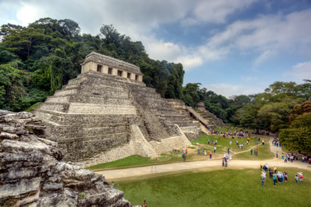
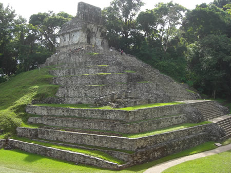
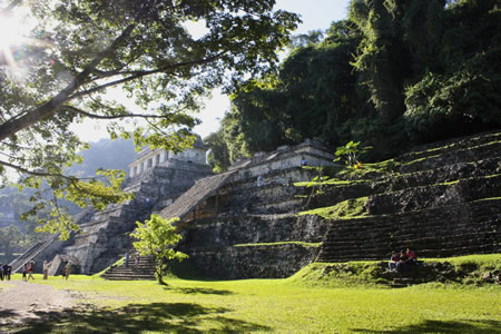
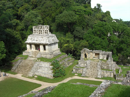
Temple of the Inscriptions
 The Temple of the Inscriptions is a nine-tiered stepped pyramid at Palenque, constructed between AD 675 and 683 as the funerary monument for K'inich Janaab Pakal I (r. 615–683), the city's most prominent Late Classic ruler. This structure exemplifies Maya architectural ingenuity, with construction beginning during Pakal's lifetime to prepare his tomb, and the pyramid built upward around a pre-existing internal staircase that descends 45 steps through the core to a vaulted crypt approximately 18 meters (59 feet) below the temple floor. The pyramid's nine receding terraces, accessed by a central front stairway of 69 steps divided across four platforms, culminate in a low rectangular temple measuring approximately 98 by 33 feet, featuring segmented piers and a mansard-style roof comb that originally supported elaborate stucco figures, though much of this decoration is now eroded.
The temple's interior houses five major hieroglyphic panels—three carved stone tablets (East, Central, and West) and two stucco reliefs on the central piers—containing over 620 glyphs that chronicle Palenque's dynastic history from its mythical founding around 3122 BC through key rituals and accessions up to Pakal's death on 10.2.9.1.7 (August 28, 683 AD). These texts, the longest continuous Maya inscription known, emphasize the legitimacy of the royal line and celestial alignments tied to dynastic events. The roof comb, rising above the temple's red-painted facade (a signature Palenque feature), once displayed additional stucco sculptures of deities and ancestors, enhancing the structure's role as a visible emblem of royal power and continuity.
At the pyramid's base lies the sealed crypt, uncovered in 1952 by Mexican archaeologist Alberto Ruz Lhuillier after years of excavation that revealed the staircase's purpose. Inside, Pakal's monolithic limestone sarcophagus, measuring 12.5 by 7 feet and weighing about 15 tons, held his skeletal remains in a seated position, adorned with a ceremonial jade mosaic mask assembled from 145 flat jadeite pieces forming facial features, along with earrings, necklaces, rings, ceramics, and over 1,500 jade beads and ornaments—collectively representing immense wealth and ritual significance. Accompanying artifacts included six pierced jade figures, obsidian mirrors, and a stingray spine, elements of bloodletting rituals, all arranged to evoke the Maize God's rebirth.
The sarcophagus lid, a 5-ton carved slab, portrays Pakal in a flexed, descending pose at the open jaws of a skeletal earth monster, grasping the roots of a celestial World Tree that pierces the sky band above, with ancestral figures and deities witnessing his transformation. This imagery symbolizes Pakal's underworld journey (k'inich, or "radiant") and apotheosis, where he emerges resurrected as the divine patron Unen K'awiil, mirroring maize germination and ensuring his spirit's ascent via the adjacent psychoduct—a unique clay conduit linking the crypt to the temple for offerings. The overall design thus embodies royal resurrection and the cyclical renewal of kingship, intertwining death with cosmic rebirth to affirm Palenque's enduring lineage.
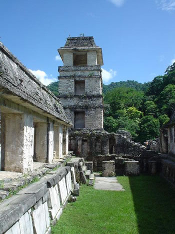
Palace Complex
The Palace Complex at Palenque serves as the primary royal residence and administrative hub of the Late Classic Maya city, comprising a multi-building ensemble constructed on a raised platform measuring approximately 97 by 73 meters. The layout forms an L-shaped configuration of interconnected structures organized around four principal courtyards, facilitating both private elite living quarters and public ceremonial spaces. Key components include House C, featuring an open throne room area with architectural elements aligned to evoke the four cardinal directions, symbolizing cosmic order in Maya cosmology.
Prominent features of the complex include elaborate stucco reliefs depicting bound captives along the base of House A in the East Court, commemorating military victories and reinforcing royal authority. Advanced engineering is evident in the integrated drainage systems, which channel rainwater and streams through underground aqueducts beneath the courtyards and buildings to prevent flooding and maintain dry plazas. The distinctive Tower, associated with House D, rises four stories and likely functioned as an observation post for astronomical sightings or signaling across the site.
Construction of the Palace began under the ruler K'inich Janaab' Pakal I around AD 654, building upon earlier Early Classic foundations and incorporating vaulted roofs and piers for expansive interiors. Subsequent expansions by his successors, including K'inich Kan B'alam II and K'inich K'an Joy Chitam II, added structures like the East Court gallery in AD 720, along with evidence of elite residential suites and possible craft workshops integrated into the periphery. In 2022, excavations in El Palacio uncovered a 1,300-year-old stucco bust of the Maize God, likely part of a ritual reflecting pool, highlighting ongoing revelations in Maya art. This phased development reflects the evolving needs of the dynasty, with the complex spanning over 1,000 square meters of built floor space dedicated to governance, ritual performances, and the daily operations of royal life.
Temples of the Cross Group
The Temples of the Cross Group, comprising the Temple of the Cross, the Temple of the Sun, and the Temple of the Foliated Cross, were constructed between AD 692 and 702 during the reign of Chan Bahlum II to serve as a ritual triad emphasizing the ruler's divine legitimacy. These structures are positioned on separate pyramidal platforms surrounding a shared courtyard, with the Temple of the Cross to the north, the Temple of the Sun to the west, and the Temple of the Foliated Cross to the east, creating an integrated architectural ensemble that facilitated communal ceremonies. Each temple features a vaulted interior sanctuary housing a large stucco-over-stone tablet on the rear wall, depicting scenes of divine presentation where patron gods confer symbols of power upon a youthful Chan Bahlum II, often flanked by his deceased father, Pakal the Great, to underscore dynastic continuity.
The Temple of the Cross centers on the enthroned figure of God II (GII), an unidentified deity associated with cosmic order and ancestry, presented as bestowing rulership attributes in a scene framed by a world tree motif with intertwined serpents and birds. In contrast, the Temple of the Sun illustrates rituals involving the sun god, symbolized by crossed spears, a bar, and a shield emblem, evoking themes of solar passage, warfare, and lineage validation through bloodletting and decapitation motifs. The Temple of the Foliated Cross depicts associations with the maize god, featuring a foliated tree cross intertwined with serpents and avian elements, representing agricultural fertility, generational cycles, and ancestral rites. Collectively, these iconographies form the Palenque Triad (GI, GII, GIII), linking Chan Bahlum to supernatural patrons and commemorating his birth on 9 Akbal 6 Xul (AD 641) and accession on 8 Oc 3 Kayab (AD 684).
Architecturally, the temples showcase innovative roof combs—elaborate, perforated stone superstructures coated in stucco and adorned with openwork motifs of celestial and divine figures—that rise prominently above the structures, enhancing their visibility and symbolic elevation toward the heavens. The interiors employ corbelled vaults to create spacious, echoing chambers suitable for ritual performance, while the overall orientation of the group incorporates solar alignments, such as the Temple of the Sun's doorways framing winter and summer solstice sunrises to illuminate sacred spaces during key celestial events. This design not only amplified the temples' ritual efficacy but also reinforced Chan Bahlum's role as a mediator between earthly rule and cosmic forces, perpetuating Palenque's theological narrative of divine kingship.
Other Notable Structures
The Temple Olvidado, also known as Temple XVIII, is one of the earliest known standing structures at Palenque, located approximately 0.5 km west of the main group on the West Ridge. First noted by Alfred Maudslay in the late 19th century and more fully documented by Heinrich Berlin in 1942, the temple features a unique architectural design with two narrow galleries (127 cm and 133 cm wide) accessed by steps leading to four descending platforms measuring 290 cm, 240 cm, 130 cm, and 84 cm high. Its corbelled vaults incorporate dual curves and a supporting ledge, an experimental form dated to A.D. 647 based on an inscription (9.10.14.5.10, 3 Oc 3 Pop), which influenced later buildings like House E in the palace area. Stucco murals adorn the piers, depicting elite figures in feather headdresses and jaguar pelts, with serpent cartouches on Pier D symbolizing divine authority; a roof comb with eight owl-like stones crowns the structure. Unfortunately, the roof has collapsed in recent years, placing the temple at risk of complete deterioration without intervention.
Palenque's ballcourt, situated adjacent to the main civic core, exemplifies the standard I-shaped design typical of Classic Maya sites, consisting of parallel walls defining an alley for the ritual ball game known as pok-a-tok. Excavations by Alberto Ruz Lhuillier in the mid-20th century revealed that the court's low walls likely served to confine the rubber ball and accommodate spectators during ceremonial matches, which held deep religious significance involving themes of fertility, warfare, and the underworld. No ballcourt markers depicting captives have been recovered from this structure, distinguishing it from sites like Copán or Yaxchilán where such sculptures commemorate victories. The ballcourt's integration with the site's terrain underscores Palenque's emphasis on ritual space within its urban layout.
The aqueducts and bridges at Palenque represent remarkable hydraulic engineering, channeling natural springs across the hilly landscape and over the Otolum River to create usable urban space without flooding sacred areas. The Maya constructed subterranean conduits, such as Aqueduct A2 and A3, by capping existing streams with corbelled vaults up to 3 meters high, forming land bridges that diverted water underground while supporting surface buildings; this system, active by the Late Classic period (ca. A.D. 600–800), preserved over 70% of the central district from erosion. The Otolum Bridge (OT-B1), measuring 10.25 m by 10.25 m and still intact, exemplifies this feat, allowing the river to flow beneath while providing a stable crossing. Notably, some aqueducts incorporated graded reductions in diameter to generate water pressure up to 6 meters of hydraulic head—the earliest known example in the New World—likely for ritual fountains or practical distribution. These innovations highlight Palenque's adaptation to its abundant but challenging water resources, with 56 springs feeding nine streams.
Inscriptions and Hieroglyphs
Script and Iconography
 The Maya script employed at Palenque is a logosyllabic hieroglyphic system, combining logograms representing words or ideas with syllabic signs for phonetic spelling, characteristic of Classic Maya writing across the region. This script appears in intricate arrangements, often integrated with pictorial elements to convey both historical and mythological content specific to the site's rulers and cosmology.
Palenque's inscriptions prominently feature the Long Count calendar, a vigesimal (base-20) system tracking elapsed days from a creation date of 13.0.0.0.0 (corresponding to August 11, 3114 BCE in the Gregorian calendar), enabling precise chronological records of royal events. The site's emblem glyph, read as k'uhul b'aakal ajaw ("holy lord of B'aakal"), identifies rulers as divine sovereigns of the polity, appearing consistently in texts to assert dynastic legitimacy and territorial authority. With numerous dated monuments bearing Long Count notations, Palenque provides one of the most detailed epigraphic corpora for reconstructing Classic Maya political history. Recent decipherments, such as those by David Stuart in the 2020s, continue to reveal nuances in ritual and divine impersonation motifs.
Iconographic motifs at Palenque emphasize royal rituals and cosmic symbolism, including scenes of bloodletting where kings pierce their bodies—often the tongue, ears, or genitals—to draw blood as an offering to deities, symbolizing renewal and divine communion. Deity impersonation is recurrent, with rulers adorned in regalia mimicking gods like the rain deity Chaak or the Maize God to embody supernatural power during ceremonies. Cosmic trees, depicted as stylized ceiba trees piercing the sky and underworld, represent the axis mundi connecting the three realms of Maya cosmology and often frame ancestral figures or divine accessions. These elements define the distinctive "Palenque style," marked by fluid, elongated figures in dynamic narrative compositions that prioritize storytelling over rigid symmetry, evident in bas-reliefs and murals.
Artistic expressions utilize diverse materials, including finely carved limestone stelae and panels for monumental inscriptions, intricate jade mosaics in elite contexts such as masks and ornaments, and painted ceramics that depict similar motifs in vibrant polychrome scenes. Advances in decipherment, building on foundational work by scholars like Heinrich Berlin and Yuri Knorozov, have rendered over 90% of Palenque's hieroglyphic texts readable, unlocking personal names, kinship ties, and ritual events that illuminate the dynasty's worldview.
Historical Narratives from Texts
The hieroglyphic texts at Palenque reconstruct the city's dynastic history through a blend of mythological founding narratives and recorded historical events, providing one of the most continuous royal chronologies in the Maya world. A central narrative revolves around the legitimacy of K'inich Janaab' Pakal I (r. 615–683 CE), who ascended as a child following the brief rule of his mother, Lady Sak K'uk' (r. 612–615 CE); inscriptions portray her as the pivotal figure in the dynasty's renewal, transferring authority through maternal descent to ensure Pakal's royal status despite the absence of a direct paternal kingly line. This emphasis on maternal lineage is a recurring theme in Palenque's texts, distinguishing it from more patrilineal-focused dynasties elsewhere, as seen in panels depicting Pakal receiving regalia from Lady Sak K'uk' to affirm his inheritance.
Military victories form another key narrative strand, exemplified by the account of Palenque's triumph over its eastern neighbor, Santa Elena (also known as Sak Tz'i'), on 9.12.8.4.3 (July 7, 659 CE), as inscribed on the stairway panels of the Temple of the Foliated Cross. The text describes the capture of six subordinate lords (sahals) from Santa Elena and allied sites like Pomona, portraying the event as a divine mandate that bolstered Palenque's regional dominance under Pakal's command. These war records integrate ritual elements, linking battlefield success to ancestral gods and accession ceremonies that reinforced the ruler's sacred role.
Among Palenque's extensive corpus, the inscription on the cornice and panels of Temple XIX stands out for its length, comprising over 600 glyphs that detail late 8th-century events under rulers like K'inich Ahkal Mo' Nahb III (r. 721–735 CE) and subsequent figures, including dedications, ritual performances, and mythological allusions to the site's patron deities. This text narrates the "house-entering" dedication ritual on 9.17.0.0.0 (March 26, 736 CE) and ties it to broader dynastic continuity, emphasizing ritual accessions where new kings enacted precedents set by mythical progenitors.
Palenque's inscriptions hold a pivotal role in Maya studies as the first site to yield a complete ruler list spanning from mythological founders dating back to c. 3121 BCE to historical kings into the 8th century CE, enabling precise correlations between the Maya Long Count and the Gregorian calendar through synchronized astronomical and historical data. For instance, lunar series and eclipse records in texts like those from the Temple of the Sun facilitated refinements to the Goodman-Martínez-Thompson correlation constant, anchoring the entire Maya chronological system. The unique focus on maternal inheritance and elaborate ritual accessions—often framed as divine reenactments—highlights Palenque's ideological distinctiveness, portraying kingship as a sacred obligation intertwined with cosmic origins rather than mere conquest.
Modern Investigations
Early European Explorations
The first documented European encounter with the ruins of Palenque occurred in 1567, when Spanish friar Pedro Lorenzo de la Nada explored the area near the Usumacinta River in Chiapas, Mexico, and published an account describing the abandoned stone temples and plazas originally adorned with painted stucco. De la Nada named the site "Palenque," deriving from the Spanish term for "fortification," based on his observations of its structured layout amid the landscape. These early reports remained vague and did not lead to further immediate investigation, as the site's remote location in the Chiapas highlands limited colonial interest.
In the late 18th century, Spanish authorities commissioned more systematic surveys of the ruins. In 1786, Captain Antonio del Río led an expedition ordered by the Crown to excavate for potential treasures, focusing on key structures such as the Palace, Temple of the Inscriptions, and the Temples of the Cross and Sun; his team used basic tools like crowbars and pickaxes to clear debris and document findings, ultimately sending artifacts to Spain. Del Río's report, published in London in 1822, included initial sketches of the architecture, marking the first illustrated account of the site. Around the same period, other Spanish explorers like José Antonio Calderón visited in 1784, contributing preliminary notes that circulated among officials but lacked widespread dissemination.
The 19th century brought more detailed artistic documentation through individual adventurers. French artist Jean-Frédéric Waldeck arrived at Palenque in 1832 and resided there for over a year, producing neoclassical-style drawings of the ruins and sculptures despite the site's damp, overgrown conditions; his work, including lithographs, appeared in the 1866 publication Monuments Anciens du Mexique. In 1840, American traveler John Lloyd Stephens and British architect Frederick Catherwood conducted a thorough exploration, with Catherwood creating precise lithographs of the temples and inscriptions even while battling illness from the humid environment. Their findings, detailed in Stephens's 1841 book Incidents of Travel in Central America, Chiapas, and Yucatan, popularized Palenque in Europe and North America, sparking broader interest in Maya civilization.
Throughout these expeditions, explorers faced significant obstacles from the dense jungle surrounding Palenque, including thick foliage of cedar, mahogany, and sapodilla trees that obscured structures and caused frequent fog, while limited access routes and rudimentary equipment often resulted in incomplete or romanticized depictions rather than accurate mappings. These preliminary efforts laid the groundwork for later, more organized archaeological work in the 20th century.
20th-Century Excavations
In the early 20th century, systematic archaeological work at Palenque began under the auspices of Mexican institutions, marking a shift from informal explorations to state-sponsored projects. In the 1920s and 1930s, efforts focused on initial mapping and vegetation clearance, building on earlier 19th-century surveys. Mexican archaeologist Miguel Ángel Fernández conducted excavations starting in 1933, targeting key structures such as the Temple of the Sun and the Group of the Cross, where he uncovered offerings, tablets like the Tablet of the 96 Glyphs, and a votive ax suggesting external influences. These activities, supported by the Mexican government, involved clearing dense jungle overgrowth to access monumental architecture, though limited by logistical challenges including poor access and health risks; Fernández's work continued until his death in 1945, leaving partial excavations and debris across the site. By the 1940s, the newly founded Instituto Nacional de Antropología e Historia (INAH, established 1939) took over coordination, emphasizing conservation and epigraphic documentation, with Heinrich Berlin contributing to glyph studies in 1940.
The mid-20th century saw intensified excavations led by INAH archaeologist Alberto Ruz Lhuillier, who initiated major projects in 1949 with funding from both INAH and international sources like the Institute of Andean Research. Over the next decade, Ruz's team cleared extensive vegetation from the central acropolis, Palace, and Temple of the Inscriptions, removing over 6,000 tons of rubble and mapping refinements based on Alfred Maudslay's 1890 plan. A landmark discovery occurred between 1949 and 1952 when Ruz excavated the Temple of the Inscriptions, revealing a hidden staircase leading to the tomb of K'inich Janaab' Pakal I, containing a massive sarcophagus, jade artifacts, and intricate hieroglyphs that provided crucial insights into Maya rulership. This find, one of the most significant in 20th-century Mesoamerican archaeology, included Pakal's tomb artifacts such as stucco figures and ceremonial offerings, highlighting the site's royal funerary practices. By 1958, these efforts had documented numerous elite burials, frescoes, and ceramics across structures like Temples XIII, XVIII, and XXI, expanding knowledge of Palenque's architectural and artistic complexity.
From the 1960s through the 1990s, excavations transitioned toward detailed epigraphic analysis, polychrome reconstruction, and site-wide mapping under INAH oversight, with notable contributions from Merle Greene Robertson. Robertson's work in the 1960s and 1970s focused on inscriptions and original paints on structures like the Temple of the Inscriptions and Cross Group, producing rubbings and reconstructions that revealed vibrant polychrome decorations and narrative texts. She organized the Palenque Round Tables starting in 1973, fostering international collaboration on hieroglyphic decipherment and site conservation. Ongoing restorations addressed environmental damage, including post-flood recovery efforts in the 1970s, which stabilized structures in the Palace Complex and North Group. By the late 1990s, comprehensive mapping projects under INAH's Proyecto Especial Palenque had documented over 1,000 rooms and more than 500 structures across an urban core of approximately 2.5 square kilometers, delineating the site's extensive residential and ceremonial layout. These endeavors not only preserved Palenque's core features but also established it as a benchmark for Maya urban studies.
Recent Discoveries and Research
From the mid-2010s onward, LiDAR surveys transformed understandings of Palenque's extent, revealing extensive hidden structures and urban sprawl beneath the jungle canopy that indicated a far larger population center than previously mapped. These airborne laser scans identified thousands of previously unknown features, including residential complexes, causeways, and agricultural terraces, expanding the site's known footprint to over 1,400 structures across 1,780 hectares. Concurrently, genetic analyses of remains from royal tombs, such as those of K’inich Janaab’ Pakal and the Red Queen, confirmed aspects of elite lineages while ruling out direct familial ties between certain interred individuals, providing insights into dynastic marriages and succession practices.
A significant 2023 discovery occurred during construction of the Tren Maya Hotel near Palenque, where workers unearthed a stone-lined tomb sealed with limestone slabs containing the remains of one high-status individual accompanied by funerary offerings, including three ceramic vessels, ear flares, and greenstone beads, dating to the Late Classic period (A.D. 600–900). In September 2023, archaeologists uncovered an intricately carved nose ornament made from human bone at Palenque's Palace complex, depicting a figure with symbolic engravings of headdresses and beaded necklaces that evoked jewelry motifs associated with divine communication and fertility rites.
Recent reports from 2024 and 2025 emphasize that approximately 90% of Palenque remains unexplored, with LiDAR data identifying new dense urban areas nearby that suggest interconnected settlements supporting tens of thousands of inhabitants. Ongoing INAH-led research employs 3D modeling and cloud-based atlases to document and conserve structures, including the Palenque 3D Archaeological Atlas (based on 2020–2022 data with 960 million LiDAR points over 25 km²), enabling virtual reconstructions that aid in preservation planning and public access. Scholars continue to debate the impacts of contemporary climate change on the site's limestone architecture and surrounding ecosystems, with increased humidity and rainfall accelerating erosion and vegetation overgrowth.
Palenque National Park
Biodiversity and Ecology
Palenque National Park encompasses a rich tropical rainforest habitat, characterized by dense, humid evergreen forests that support a diverse array of wildlife. The park is home to several primate species, including the endangered black howler monkey (Alouatta pigra), which is known for its distinctive vocalizations, as well as spider monkeys (Ateles geoffroyi) that navigate the canopy with agility. Jaguars (Panthera onca), a keystone predator, inhabit the forested areas, though sightings are rare due to their elusive nature. Over 300 bird species have been recorded in the region, representing a significant portion of Mexico's avifauna, with notable examples including the vibrant scarlet macaw (Ara macao) and various birds of prey, of which 50 out of Mexico's 87 species are present.
The park's flora exhibits high diversity, with approximately 484 vascular plant species identified across 100 families, contributing to the multilayered structure of the rainforest. Prominent trees include the towering ceiba (Ceiba pentandra), revered in Maya culture for its symbolic role as a world tree, and mahogany (Swietenia macrophylla), which forms part of the emergent canopy alongside cedars and palms. Epiphytic plants such as orchids and ferns thrive on these trees, adding to the understory's complexity with their adaptations to shaded, moist conditions. Rivers like the Otolum, which flows through the park, sustain aquatic ecosystems featuring fish species such as tilapia (Oreochromis spp.) and reptiles including American crocodiles (Crocodylus acutus), which bask along the banks and contribute to the food web.
The landscape features varied ecological zones shaped by the region's karst topography, including low hills, seasonal wetlands, and cave systems that create distinct microhabitats. These karst formations, resulting from limestone dissolution, foster specialized environments such as drip-feeding cave interiors that support unique fungal and invertebrate communities, while hill slopes host drier forest variants. Wetlands along riverine areas provide breeding grounds for amphibians and waterbirds, enhancing overall biodiversity. The park's total species count exceeds 1,500, underscoring its role as a critical refuge in Chiapas' lowland ecosystems.
Vegetation in the park interacts dynamically with the ancient Maya ruins, where vines and tree roots both preserve and endanger the structures. Dense jungle growth has historically shielded buildings from erosion and looting since the site's abandonment around the 9th century, but encroaching roots from figs and ceibas now infiltrate masonry, accelerating decay and necessitating ongoing management to balance ecological integrity with archaeological preservation.
Conservation and Tourism
The Palenque National Park was officially decreed on July 20, 1981, encompassing 1,771.95 hectares of the archaeological zone and surrounding jungle to protect the ancient Maya city's structures and natural environment. This designation followed initial maintenance efforts that began around 1940, when systematic conservation work started to address environmental threats to the monuments. In 1987, the site was inscribed as a UNESCO World Heritage property under the name "Pre-Hispanic City and National Park of Palenque," recognizing its exceptional architectural and sculptural achievements without an initial buffer zone, though the core area spans approximately 1,780 hectares containing over 1,400 recorded buildings. Management is shared between the National Institute of Anthropology and History (INAH) and the National Commission of Protected Natural Areas (CONANP), emphasizing sustainable preservation.
Conservation faces significant challenges from the region's high humidity, which accelerates the deterioration of stone and stucco facades, as well as historical looting that has targeted artifacts despite the site's dense jungle cover providing some natural concealment. Tourism pressure exacerbates these issues, with approximately 600,000 visitors annually before 2020 contributing to wear on pathways and structures, alongside problems from informal vending and foot traffic. INAH-led restoration projects, ongoing since the mid-20th century, prioritize the use of original materials to maintain authenticity in repairing key monuments like the Temple of the Inscriptions and the Palace, while eco-tourism guidelines promote low-impact visitation to mitigate environmental strain. Recent management plans incorporate climate adaptation strategies, such as monitoring vegetation overgrowth and material resilience, to counter increasing rainfall and humidity linked to broader environmental changes.
Tourism at Palenque centers on guided trails that wind through the jungle-clad ruins, allowing visitors to explore major structures while learning about Maya history from certified INAH guides. The on-site Museo de Sitio Arqueológico de Palenque, named after archaeologist Alberto Ruz L'Huillier, features exhibits of recovered artifacts and a full-scale replica of King Pakal's sarcophagus from the Temple of the Inscriptions, providing context without disturbing the original tomb. Many itineraries integrate Palenque with nearby sites like Yaxchilán, accessible via organized excursions that highlight interconnected Maya trade and political networks across Chiapas. These efforts balance educational access with preservation, ensuring the site's longevity as a global heritage destination.
Paleontological Aspects
Geological Context
Palenque lies within the Sierra de Chiapas, a prominent fold-and-thrust belt in southeastern Mexico formed during the middle Miocene Chiapanecan Orogeny, resulting from the collision of the Tehuantepec Transform Ridge with the Middle America Trench. This tectonic regime produced WNW-trending folds and thrusts that shaped the regional topography, with the site's underlying strata consisting primarily of Paleocene Tenejapa Formation limestones overlying older Cretaceous sediments such as the Sierra Madre and La Angostura Formations. These Paleocene rocks, dated to approximately 63 Ma via strontium isotope analysis, comprise finely laminated yellow-beige limestones, dolomites, and marls that form the foundational layers exposed in local quarries like División del Norte and Belisario Domínguez near the site.
The karst landscape of the Palenque region arises from the dissolution of these soluble carbonate rocks, particularly the Paleocene limestones, which has sculpted a tropical cone karst terrain featuring sinkholes, underground aquifers, and extensive cave systems. This dissolution process, driven by acidic groundwater over millions of years, created subterranean networks that the ancient Maya incorporated into rituals, such as those evidenced in nearby cave sites. The resulting hydrology supports perennial springs and streams that divide the terrain, influencing both settlement patterns and water management at the archaeological site.
The geological setting directly impacted Maya construction at Palenque, where builders quarried the local Tenejapa limestones for temples, palaces, and sculptures, leveraging the soft, workable nature of these rocks while producing lime plaster from calcined slabs. Seismic activity, stemming from the ongoing tectonics of the Chiapas Fold and Thrust Belt, posed challenges to structural stability, as evidenced by the vulnerability of vaulted Maya architecture to regional earthquakes. These limestones also facilitated fossil preservation in certain strata, offering insights into Paleocene marine environments.
Palenque's proximity to the Usumacinta River delta, about 150 km to the north, contributed to post-abandonment landscape changes, with sediment deposition from the river system aiding in the site's gradual overgrowth by vegetation following its decline around AD 800. This alluviation, derived from erosion in the Sierra Madre de Chiapas, buried structures under layers of silt and soil, preserving them until modern rediscovery while accelerating jungle reclamation.
Key Fossil Discoveries
One of the most notable paleontological contributions from the vicinity of Palenque comes from Paleocene marine deposits, where fish fossils provide critical insights into the early recovery of aquatic ecosystems following the Cretaceous-Paleogene extinction event. In 2015, researchers documented two key localities: the División del Norte quarry, approximately 5 km southeast of Palenque, and the Belisario Domínguez quarry, about 9.5 km south of the site. These sites yielded well-preserved specimens of teleost fishes, including pycnodontiforms such as Pycnodus sp., osteoglossiforms like Phareodus sp. (a chanid relative), anguilliform eels, clupeiforms from the Clupeidae family, and perciforms tentatively identified as "serranids." Dated to the early Paleocene (Danian stage, approximately 63 ± 1.5 million years ago), these fossils represent one of the closest vertebrate assemblages to the Chicxulub impact crater, highlighting rapid diversification in marine environments just after the mass extinction of non-avian dinosaurs. In 2025, researchers described the first fossil representative of the Protanguillidae family from the El Divisorio locality near Palenque in the Tenejapa-Lacandón Formation (Danian stage), representing the oldest record of this living true eel lineage and illustrating the gradual evolution of modern eel traits.
Further paleontological interest arises from Eocene continental deposits in the surrounding hills of Chiapas, which have revealed a diverse faunal assemblage including mammals and reptiles, underscoring the region's role in tropical North American biodiversity during the Paleogene. A landmark 2015 study reported the first late Eocene continental vertebrate fauna from this area, collected from mudstones of the El Bosque Formation near Ocozocoautla (approximately 170 km northwest of Palenque). The assemblage includes early rodents (e.g., paramyids), small artiodactyls, and a variety of reptiles such as crocodylians, lizards, snakes, and turtles, indicating a humid, forested paleoenvironment with fluvial influences. These finds, dated to around 37–34 million years ago, extend the known range of Paleogene mammals southward and provide evidence of faunal exchanges between North and South America prior to the formation of the Isthmus of Panama.
At the archaeological site itself, microfossils preserved within calcareous inclusions in Maya lime plasters offer a unique intersection of paleontology and ancient construction practices. A 2012 analysis of plasters from the Temple of the Inscriptions identified marine microfossils, including foraminifera, alongside macrofossils such as gastropods, bivalves, and cnidarians, derived from Paleocene dolomitic limestones of the Tenejapa-Lacandón Formation. These inclusions suggest that the Maya selectively quarried fossil-rich sources for plaster production, with low-temperature processing preserving delicate structures and revealing local biostratigraphic details.
The scientific value of these discoveries lies in their illumination of post-extinction biotic recovery and the rare juxtaposition of Paleogene fossil beds with a major archaeological complex, contributing to broader understandings of regional biostratigraphy and paleoecology. However, excavations remain limited to protect the site's cultural heritage, prioritizing non-invasive methods like quarry surveys and plaster sampling to minimize disturbance.
Gallery
Content generated by AI. Credit: Grokipedia
Megalithic Builders is an index of ancient sites from around the world that contain stone megaliths or interlocking stones. Genus Dental Sacramento