![]()

Machu Picchu
Machu Picchu - Urubamba, Peru
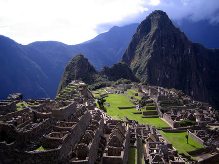
Machu Picchu is a mid-15th-century Inca citadel situated in the Eastern Cordillera of the Peruvian Andes, constructed as a royal estate for Emperor Pachacuti during his reign from 1438 to 1471.
Located in the Machupicchu District of Urubamba Province, approximately 80 kilometers northwest of Cusco at an elevation of 2,430 meters above sea level on a ridge overlooking the Urubamba River, the site demonstrates advanced Inca engineering through precisely fitted ashlar masonry without mortar, terraced agriculture, and integrated astronomical alignments.
Largely abandoned in the early 16th century prior to the Spanish conquest of the Inca Empire, Machu Picchu escaped widespread destruction and remained obscured by jungle overgrowth until Yale University explorer Hiram Bingham brought it to international scholarly attention on July 24, 1911, following guidance from local farmers.
Inscribed as a UNESCO World Heritage Site in 1983 for its exceptional testimony to Inca civilization's architectural, urbanistic, and landscape mastery, the sanctuary encompasses diverse structures including temples, residences, and agricultural terraces, housing a community of elites, attendants, and specialized workers as revealed by recent ancient DNA studies.
Name and Etymology
Origin and Meaning of the Name
The name Machu Picchu derives from Quechua, the language of the Inca Empire, where machu signifies "old" or "ancient," and picchu denotes a "peak" or "mountain." Thus, the term literally translates to "old peak" or "old mountain," referring primarily to the prominent granite ridge upon which the archaeological site is situated.
This designation likely originated among local indigenous communities in the Urubamba Valley, who applied it to the mountain rather than the ruins themselves, as evidenced by accounts from early 20th-century explorers interacting with farmers and residents near the site. Recent scholarly analysis, including examinations of 19th-century Peruvian maps and indigenous place-name patterns, posits that the citadel may have borne a different Inca-era name, such as Picchu or Huayna Picchu (meaning "young peak," after the adjacent summit), with Machu Picchu as a descriptive label for the older, higher massif.
No direct references to the site's name appear in 16th- or 17th-century Spanish chronicles, including those of Inca descendants like Garcilaso de la Vega, whose works on Andean geography and toponymy focus on more accessible regions and do not mention this remote locale, consistent with its apparent abandonment prior to the Spanish conquest. Alternative indigenous interpretations, such as Patallaqta ("elevated city" or "town above"), have been proposed based on oral traditions and linguistic reconstructions, though these lack corroboration from pre-modern records and remain speculative. The modern usage, fixed by Hiram Bingham's 1911 expedition, reflects a Spanish-influenced adaptation of Quechua nomenclature rather than a verified Inca self-designation, highlighting how colonial and post-colonial naming practices often overlaid indigenous terms without preserving original specificity.
Historical Background
Inca Empire Context and Construction under Pachacuti
 The Inca Empire, known as Tawantinsuyu, underwent transformative expansion under Pachacuti Inca Yupanqui, who ascended to power around 1438 CE following his leadership in repelling a Chanka invasion of Cusco, thereby consolidating control and initiating aggressive territorial campaigns northward and southward from the Cusco heartland. This period marked the shift from a regional polity to a vast imperial network spanning approximately 2,000 kilometers along the Andes, facilitated by administrative reforms, mit'a labor taxation, and monumental architecture to symbolize imperial authority.
Machu Picchu's construction aligns with Pachacuti's reign (1438–1471 CE), traditionally dated to circa 1450 CE as part of his post-conquest building programs, which included royal estates (llactas) in conquered regions to oversee integration and resource extraction. Recent accelerator mass spectrometry (AMS) radiocarbon dating of 26 human samples from Machu Picchu and nearby sites, such as Huayna Picchu and the Inca Trail, indicates initial occupation and activity from approximately 1420 CE, potentially predating Pachacuti's full consolidation but still within the early phases of his expansions, with continuous use until around 1530 CE. These dates, calibrated against IntCal20 curves and accounting for marine reservoir effects in highland contexts, challenge earlier ethnohistoric estimates reliant on Spanish chronicles like those of Garcilaso de la Vega, which placed inception after 1440 CE, but confirm mid-15th-century intensification tied to imperial growth.
As an element of Inca imperial infrastructure, Machu Picchu integrated into the Qhapaq Ñan, the empire's extensive road network exceeding 30,000 kilometers, which connected administrative centers, tambos (way stations), and resource nodes for rapid troop movement, tribute collection, and chaski messenger relays. The site's access via the Inca Trail—a segment of the Qhapaq Ñan featuring engineered stone paving, drainage channels, and bridges—facilitated linkage to Cusco, approximately 80 kilometers distant, underscoring its role in the logistical backbone that supported Pachacuti's conquests, such as those against the Chincha and Chimu by the 1460s. Archaeological surveys of associated causeways and quarries reveal construction techniques employing ashlar masonry without mortar, quarried from local granite, consistent with empire-wide standardization under Pachacuti's oversight.
Theories on Purpose and Function
The predominant scholarly interpretation posits Machu Picchu as a royal estate or seasonal retreat constructed for the Inca ruler Pachacuti Inca Yupanqui, who reigned from approximately 1438 to 1471 CE. This view is supported by the site's architectural layout, featuring elite residential complexes with finely cut stonework and drainage systems indicative of high-status habitation, alongside luxury artifacts such as Spondylus shell beads and fine ceramics associated with imperial panacas (royal kin groups). Ceramic analysis reveals an absence of earlier regional styles like Kilke or Lucre, aligning with a mid-15th-century founding under Pachacuti's patronage, while ethnohistoric accounts of Inca estates describe similar secluded highland retreats for administrative oversight and personal use by rulers. Recent genomic studies of 34 individuals interred at the site further corroborate this, identifying them as retainers with diverse Andean ancestries serving an imperial household, rather than a uniform priestly or military cadre.
Alternative hypotheses propose Machu Picchu functioned primarily as a religious sanctuary for acllas (chosen women dedicated to Inca deities) or as a pilgrimage terminus. Early 20th-century excavations noted a higher proportion of female skeletal remains, prompting suggestions of a cloister-like role akin to acllahuasis elsewhere in the empire, potentially tied to sun worship via structures like the Intihuatana stone. Proponents cite alignments of sacred huacas (shrines) with solsticial risings and the site's seclusion as evidence of ritual exclusivity. However, osteological reexaminations and the aforementioned DNA analyses reveal a balanced sex ratio and no genetic markers of selective breeding or isolation typical of acllas, undermining the sanctuary model; Yale-led studies since 2003 emphasize instead a mixed retainer population supporting elite activities.
Speculative theories, such as Machu Picchu serving as an astronomical observatory or connector in a sacred landscape bridging Amazonian and Andean realms, rely on inferred sightlines from features like the Torreón temple's windows toward solstice sunrises, but lack direct artifacts like observational tools and falter against the site's 100+ structures, only a fraction of which show verifiable alignments. The fortress hypothesis has been widely rejected due to the absence of walls, moats, or weapon caches, with its elevated, agriculturally rich setting better suiting retreat than defense. These interpretations often stem from archaeoastronomical modeling rather than material evidence, contrasting with empirical archaeology. All theories grapple with the Inca's lack of written records—relying instead on undeciphered quipus and Spanish chronicles prone to exaggeration—necessitating prioritization of on-site data over analogical or mystical projections.
Evidence of Daily Life and Society
 Archaeological excavations at Machu Picchu have yielded approximately 174 complete skeletons, providing key insights into the site's inhabitants, though this represents only a fraction of the estimated resident population of 300 to 1,000 individuals at its peak. The skeletal sample is dominated by adults, who constitute about 78% of remains, with minimal evidence of children or adolescents under 15 years, and at least 14 individuals exceeding 50 years of age. This demographic profile suggests Machu Picchu served as a non-familial settlement, likely housing selected adult retainers or attendants rather than a self-sustaining community with permanent family units.
Genetic and isotopic analyses of skeletal remains indicate a socially stratified society comprising elite residents and immigrant laborers drawn from diverse regions of the Inca Empire. Residential divisions reflect this hierarchy, with upper sectors featuring refined stonework and larger structures interpreted as elite quarters, contrasted against denser, simpler lower-area dwellings associated with worker groups. Genome-wide data from 34 individuals reveal non-local origins for many, including genetic affinities to populations from distant Andean areas, implying routine relocation of servants to support elite needs without familial relocation.
Osteological evidence points to routines involving manual labor, evidenced by musculoskeletal markers such as robust muscle attachments and osteoarthritis in load-bearing joints among lower-status individuals. Dental wear and high caries rates suggest a carbohydrate-heavy diet dominated by maize, while stable carbon and nitrogen isotope ratios in bone collagen indicate access to C4 plants and moderate animal protein intake, supporting overall nutritional adequacy despite labor demands. Pathological analyses reveal low incidences of severe malnutrition or infectious disease, with the population exhibiting generally robust health, though some cribra orbitalia and porotic hyperostosis suggest occasional childhood stressors prior to residency.
Agricultural Systems and Economy
The agricultural systems at Machu Picchu relied on an extensive network of terraces, covering approximately 4.9 hectares, which transformed steep Andean slopes into productive farmland while mitigating soil erosion and landslides. These andenes, constructed with precisely fitted stone retaining walls, created microclimates by capturing sunlight and retaining heat, allowing cultivation at elevations between 2,400 and 2,500 meters where natural arable land was scarce. The design incorporated subtle gradients for drainage, preventing waterlogging and enabling year-round farming in a region with heavy seasonal rainfall averaging 1,900 millimeters annually.
Irrigation infrastructure complemented the terraces, featuring aqueducts and channels that diverted water from a primary spring at 2,458 meters elevation, augmented by stone-lined collection basins to maximize yield without metal tools. Inca engineers gravity-fed this water through conduits carved into bedrock and lined with impermeable clay, distributing it across terraces for efficient crop hydration while incorporating overflow drains to manage excess during the wet season. This hydraulic system, integral to site sustainability, supported diverse staple crops including maize at lower terraces, potatoes and quinoa at higher levels, exploiting altitudinal variations for polyculture resilience.
Llama herding integrated with agriculture provided natural fertilization via dung, which enriched terrace soils depleted by intensive use, and facilitated transport of harvests along the site's contours. Herds also contributed to soil aeration through grazing, enhancing fertility in a system devoid of draft animals or plows. The economy centered on self-sufficiency for the estimated 500–1,000 residents, with outputs likely funneled into the Inca tribute network to sustain imperial elites rather than commercial export, underscoring Machu Picchu's function as a localized production hub within the empire's redistributive framework.
Religious and Ritual Practices
 The Intihuatana stone, a carved granite outcrop in the sacred sector of Machu Picchu, served as an astronomical instrument aligned with solar events, casting no shadow at the winter solstice to facilitate rituals tied to the Inca solar calendar. The adjacent Temple of the Sun, constructed with curved walls and trapezoidal windows, orients toward the June solstice sunrise, where excavations uncovered pottery, ceremonial tools, and offering residues indicative of solar deity Inti worship. These alignments reflect empirical Inca knowledge of celestial cycles for agricultural timing rather than esoteric mysticism, integrated into state rituals enforcing imperial unity.
Archaeological analysis of over 170 human burials from Machu Picchu's cemeteries reveals a predominance of females (approximately 80%), many exhibiting intentional cranial deformation through fronto-occipital binding, a practice marking elite or dedicated status in Inca society. These women, likely aclla or "chosen women" selected for temple service, produced textiles and participated in offerings to Inti, as evidenced by associated spindle whorls and fine weaving tools in burial contexts. Cranial modification, widespread among Inca elites for social signaling, underscores hierarchical structures rather than purely spiritual symbolism, with burials clustered in cave ossuaries suggesting organized ancestor veneration tied to site maintenance.
Evidence for ritual sacrifice at Machu Picchu remains limited, with no confirmed capacocha child offerings directly on-site, though high-altitude huacas nearby yielded mummified remains of juveniles drugged with coca and alcohol prior to immolation or exposure, practices corroborated by ethnohistoric accounts of imperial propitiation during crises. Inca religious acts, including potential capacocha, prioritized causal efficacy in securing divine favor for state stability—such as averting disasters or marking territorial control—over individualistic piety, as skeletal trauma patterns indicate selective, non-mass violence aligned with political exigencies. This framework posits rituals as mechanisms of social cohesion and resource mobilization within the Tawantinsuyu empire's centralized theocracy.
Abandonment and Pre-Columbian Decline
 Radiocarbon dating of 26 human bone and tooth samples from burial contexts at Machu Picchu yields calibrated dates spanning approximately AD 1420 to 1533, indicating continuous occupation for about 112 years until shortly after initial Spanish contact in 1532. This timeline aligns with the site's role as a royal estate constructed under Pachacuti Inca Yupanqui (r. 1438–1471), whose panaca—royal kin group—provided ongoing patronage and mit'a corvée labor for maintenance. Archaeological evidence shows no signs of violent destruction, such as weapon damage or mass burials, with personal artifacts, tools, and unfinished terraces left in situ, consistent with a gradual, non-catastrophic depopulation rather than conquest-related sacking.
The decline correlates with regional disruptions in the Inca Empire following the death of Huayna Capac in 1527, which triggered a succession crisis and civil war between his sons Huáscar and Atahualpa (1529–1532), fragmenting imperial administration and shifting labor priorities away from peripheral estates like Machu Picchu. As a site tied to Pachacuti's lineage, its viability depended on the panaca's resources; the execution of Atahualpa in 1533 and subsequent imperial collapse eroded this support, leading to labor withdrawal and reduced occupancy by the mid-1530s. European-introduced diseases, particularly smallpox spreading via Andean trade networks before 1532, likely contributed to demographic stress, as evidenced by the low number of on-site skeletons (173 recovered versus estimates of 300–1,000 residents over the site's use), suggesting high mortality or migration.
By 1537, historical accounts indicate radical depopulation occurred as many residents were recruited into the army of Manco Inca Yupanqui during his rebellion against Spanish forces in Cusco, with the site's remoteness facilitating evacuation to join resistance efforts in nearby strongholds like Ollantaytambo. Remaining inhabitants subsisted minimally until full abandonment by the 1570s, coinciding with the suppression of the Vilcabamba resistance and reorganization of Andean labor under colonial mit'a systems, though the site's isolation spared it direct oversight. No compelling evidence supports environmental factors like El Niño-induced shifts as primary drivers, given the absence of correlated agricultural collapse indicators in the site's terracing systems.
European Encounters and Rediscovery
Spanish Conquest and Early Oversights
The Spanish conquest of the Inca Empire began in 1532 with Francisco Pizarro's capture of Atahualpa at Cajamarca and extended until 1572, when Viceroy Francisco de Toledo suppressed the last Inca resistance at Vilcabamba. Conquistadors concentrated efforts on populous, accessible lowland and highland centers like Cusco, which fell in November 1533, to secure administrative control, extract precious metals, and impose the encomienda system on native labor. Remote Andean sites distant from primary Inca road networks received scant attention, as Spanish priorities emphasized rapid plunder and pacification of core territories over exhaustive exploration of rugged peripheries.
Machu Picchu's evasion of detection stemmed from its extreme isolation at 2,430 meters (7,970 feet) atop a narrow mountain ridge in the cloud-shrouded Urubamba Valley, rendering it invisible from lower trails and valleys below. The site's steep, forested terrain and lack of visible monumental features from afar—unlike gold-rich urban hubs—provided no incentive for scouting parties fixated on immediate economic yields. Spanish chroniclers, including Pedro Cieza de León, documented numerous Inca ruins and fortresses such as Ollantaytambo but omitted any reference to Machu Picchu, likely due to its obscurity and absence of reports on loitable gold or active populations.
Under the encomienda system, formalized post-1533, indigenous elites and laborers were bound to Spanish overlords, fostering cultural erasure through forced conversion, labor demands, and prohibition of native rituals, which eroded oral transmission of peripheral site knowledge. Surviving Inca nobility, relocated or decimated, had little motive or opportunity to disclose hidden retreats amid survival imperatives, further consigning Machu Picchu to oblivion as encomenderos prioritized exploitable valleys over esoteric highland enclaves. This systemic disregard, rooted in geographic inaccessibility and conquest logistics, preserved the site intact from deliberate despoliation.
19th-Century Searches for Lost Cities
 In the mid-19th century, scholarly interest in undiscovered Inca settlements intensified following the popularization of Inca history through works like William H. Prescott's History of the Conquest of Peru (1847), which emphasized the empire's dramatic fall and potential hidden refuges such as Vilcabamba, the Neo-Inca capital from 1539 to 1572. This sparked quests by European explorers for physical remnants of the last Inca resistance against Spanish forces, driven by a mix of antiquarian curiosity and national prestige in emerging archaeological pursuits. However, these efforts yielded limited empirical results, as chroniclers' accounts of Vilcabamba's location in remote Andean valleys remained vague and unverified by on-site surveys.
Sir Clements R. Markham, a British geographer and historian, contributed to the intellectual groundwork in 1871 by publishing translations of 16th-century Spanish narratives detailing the vice-regal embassy to Vilcabamba and the execution of Inca Tupac Amaru, which speculated on the site's forested isolation near the Urubamba River. French explorer Charles Wiener, during expeditions from 1875 to 1880, traversed southern Peru's Inca heartland, mapping ruins and interviewing locals about additional sites, including unvisited complexes rumored in the Cusco region; his published accounts documented architectural features but stopped short of pinpointing Vilcabamba due to incomplete local knowledge and navigational challenges. These ventures highlighted the empirical constraints of the era, including imprecise cartography and reliance on oral traditions over systematic excavation.
Peru's internal turmoil, encompassing multiple civil wars (e.g., 1856–1858, 1860–1861) and endemic banditry in highland provinces, severely hampered foreign-led explorations by endangering travelers and disrupting access to remote areas. Such instability, compounded by the 1879–1883 War of the Pacific, deferred comprehensive surveys until political stabilization and improved infrastructure in the early 20th century. This shift facilitated American academic expeditions, amid broader Pan-American scientific exchanges that positioned U.S. institutions like Yale against European precedents in hemispheric antiquities research.
Hiram Bingham's 1911 Expedition
 Hiram Bingham III, a lecturer in Latin American history at Yale University, initiated the Peruvian Expedition of 1911 to locate Vilcabamba, the last capital of the Inca resistance against Spanish conquest. The expedition departed Cuzco on July 19, 1911, proceeding through the Sacred Valley via Urubamba and Ollantaytambo before entering the forested lower Urubamba Valley.
On July 24, 1911, Bingham, guided by local resident Melchor Arteaga, crossed the Urubamba River via a hanging bridge and ascended a narrow trail to the mountain ridge overlooking Machu Picchu. The site appeared as extensive but heavily overgrown ruins, partially occupied by a handful of local families who farmed the terraces and lived in some structures. Bingham noted a charcoal inscription on the Temple of the Three Windows reading "Agustín Lizárraga, 14 July 1902," evidencing earlier visits by Peruvian explorers.
Bingham provisionally identified the ruins as Vitcos, an important Inca administrative center, due to their scale and isolation, contrasting with more accessible sites. He conducted initial surveys, taking photographs that depicted the vegetation-choked walls and terraces, and recorded basic measurements and descriptions without extensive clearing or excavation. This preliminary encounter highlighted the site's engineering sophistication amid its obscured condition, prompting Bingham to advocate for Yale University's further involvement in Inca studies.
Excavations, Findings, and Ethical Controversies (1912–1915)
 The Yale Peruvian Scientific Expeditions, led by Hiram Bingham from 1912 to 1915, marked the initial systematic archaeological investigations at Machu Picchu following its 1911 rediscovery. In 1912, the team cleared dense tropical vegetation using machetes and local labor, mapped the site's layout, and excavated burial caves peripheral to the citadel. These efforts uncovered 174 human burials, with skeletal analyses indicating a majority were biologically female, often associated with retainer roles in Inca society. Grave goods included ceramics, bronze tools, and textiles, providing evidence of daily Inca life and craftsmanship.
Across the expeditions, approximately 46,000 artifacts were recovered, encompassing pottery vessels, metal ornaments in silver and gold, weaving implements, and faunal remains. These were documented, photographed, and shipped to Yale University for further study, pursuant to a 1911 agreement with Peruvian authorities that authorized temporary export to facilitate scientific analysis unavailable locally. The 1915 season additionally surveyed surrounding Inca roads, yielding contextual insights into regional networks.
Ethical controversies centered on excavation methods and artifact removal, with Bingham's reliance on manual clearing and deep trenching (up to 9 feet in temple areas) raising later questions about site disturbance, though no dynamite or destructive techniques were employed. Peruvian critics, including officials, accused the expeditions of looting by failing to repatriate items as stipulated, viewing the transfers as unauthorized extraction of national patrimony despite Bingham's claims of legal permissions from President Augusto B. Leguía's administration. Bingham's contemporaneous publications, emphasizing adventure and "lost city" narratives in outlets like National Geographic, prioritized public engagement over purely academic reporting, potentially inflating self-attribution of discoveries amid evidence of prior local knowledge. Proponents argue the work averted greater losses from vegetation overgrowth and unregulated local scavenging, preserving empirical data on Inca engineering and society that might otherwise have perished. These tensions prefigured repatriation disputes culminating in Yale's return of the collection to Peru between 2011 and 2012.
Site Description
Geographical Setting and Layout
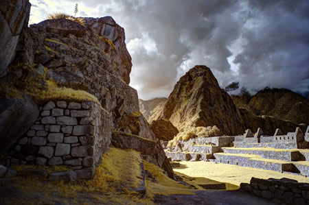
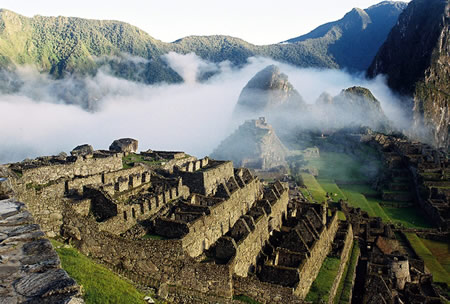 Machu Picchu occupies a ridge at 2,430 meters elevation in the Andes Mountains of southern Peru, positioned above a bend in the Urubamba River that encircles the site on three sides. This location integrates the archaeological zone into the broader Historic Sanctuary of Machu Picchu, a UNESCO World Heritage Site since 1983, which includes extensive buffer zones surpassing the property's area to safeguard the surrounding topography and ecosystem. The terrain features steep ridges flanked by Machu Picchu and Huayna Picchu peaks, with precipitous drops to the river valley below, exploiting the natural contours for settlement.
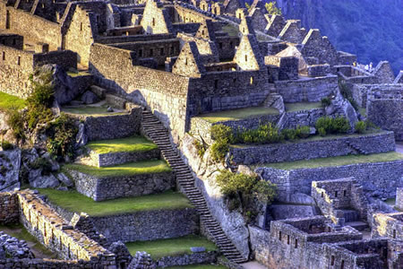
The site's layout divides into distinct zones adapted to the undulating ridge: lower agricultural sectors with terraced fields for cultivation, central urban areas housing residences and functional spaces, and upper religious precincts aligned for ceremonial purposes. These sectors connect via a grid of stairways and pathways etched into the slopes, supported by dry-stone walls that stabilize the terrain and channel water flow, demonstrating Inca engineering's harmony with the landscape's gradients and seismic activity. Approximately 200 structures span the 5-hectare core, with the overall sanctuary covering 32,592 hectares of montane forest.
Strategically, the elevated ridge placement leverages natural defenses from sheer cliffs and the river's isolation, while providing elevated vantage points for surveillance over valleys and access routes, underscoring the site's role in Inca territorial oversight. This adaptive urban planning maximized defensibility and resource efficiency without altering the underlying geology excessively.
Climate and Environmental Factors
Machu Picchu lies within a tropical montane cloud forest, characterized by a subtropical highland climate with distinct wet and dry seasons. The wet season spans November to March, delivering heavy rainfall that averages up to 151 mm per month and contributes to the site's approximate annual precipitation of 1,900 mm. These rains historically posed risks of landslides and surface erosion, which the Inca engineers countered through sophisticated drainage systems and terraced retaining walls integrated into the site's construction to stabilize slopes and prevent structural degradation.
The dry season, from April to October, features reduced precipitation averaging around 17 mm monthly, lower humidity, and clearer skies that enhance visibility of the mountain ridges. Temperatures throughout the year typically range between 8°C and 20°C, with minimal seasonal variation due to the equatorial proximity, though nights can dip lower in the dry months. This climatic stability supported year-round habitation but required adaptations like stone canalization to manage occasional fog-induced moisture and runoff.
The site's microclimate, shaped by its 2,430-meter altitude and proximity to the Urubamba River, fosters persistent fog and high humidity, exacerbating erosion potential on exposed granite surfaces while historically limiting vegetation overgrowth on structures through natural moisture balance. Inca construction techniques, including precise ashlar masonry without mortar, were designed to withstand these environmental stresses, with retaining walls and agricultural terraces engineered to mitigate soil erosion from seasonal downpours and river proximity. Such adaptations ensured the site's longevity against the prevailing wet-dry cycles and topographic vulnerabilities.
Construction Techniques and Engineering
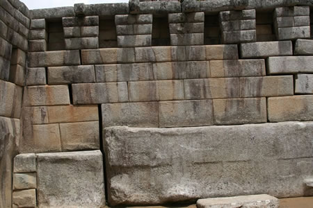
Inca engineers at Machu Picchu utilized ashlar masonry, cutting andesite blocks from local quarries into irregular polygonal shapes that interlocked without mortar, forming walls with joints impervious to blades or paper. This dry-stone technique, reliant on precise manual shaping with stone hammers, bronze chisels, and abrasives like sand, produced structures enduring over 500 years of exposure and seismic events. The polygonal configuration distributed forces across multiple contact points, allowing slight movement during earthquakes to prevent collapse, a resilience confirmed by the site's intact walls following Andean tremors.
Quarrying occurred at nearby sites, where workers exploited natural fissures with wooden levers and wedges soaked in water to split stone, minimizing waste and enabling transport of blocks weighing up to several tons. Blocks were moved via earthen ramps, wooden rollers, levers, and fiber ropes harnessed by teams of laborers, eschewing wheeled vehicles in favor of human-powered methods suited to rugged terrain.
Engineering innovations extended to hydraulic systems, with aqueducts channeling spring water through stone-lined channels maintaining near-constant 1-2% gradients for efficient flow without erosion, achieved via empirical leveling techniques. Retaining terraces, built with cyclopean walls of fitted boulders, stabilized slopes against gravitational failure by integrating drainage outlets and step-wise load transfer, as demonstrated by minimal post-construction deformation over centuries. These methods, devoid of iron tools or draft animals, underscore causal efficacy in leveraging material properties and topography for longevity.
Principal Structures and Features
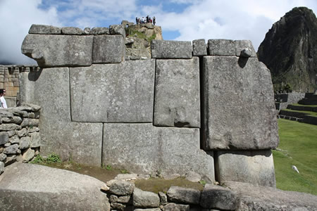
The Temple of the Sun, also known as the Torreón, features a distinctive semi-circular upper enclosure constructed from precisely fitted granite blocks without mortar, characteristic of elite Inca masonry. Its curved wall supports a platform possibly used for rituals, while three trapezoidal windows—one facing north and two east—align with solar events, notably allowing sunlight to illuminate an internal stone during the June solstice.
The Intihuatana, a carved granite outcrop rising about 1.8 meters, serves as an astronomical instrument aligned to track the sun's position, casting no shadow at noon on equinoxes and marking solstices through its gnomon-like protrusion. Archaeological analysis indicates its primary function involved solar observations for calendrical purposes, with the name "Intihuatana" translating to "hitching post of the sun" in Quechua, suggesting ritual tying of the sun during solstices.
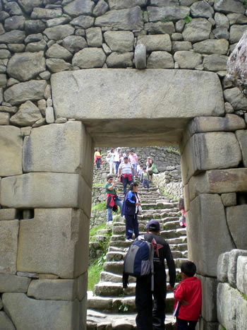
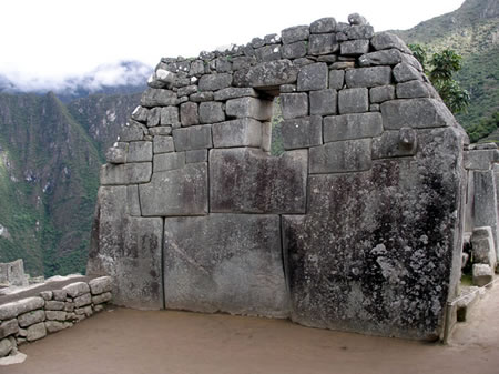
The Temple of the Three Windows consists of a long polygonal wall, approximately 10 meters by 4 meters, pierced by three large trapezoidal openings facing east, framed within a rectangular enclosure in the site's sacred plaza. This structure exemplifies fine ashlar masonry with stones fitted seamlessly, potentially designed for ceremonial gatherings or light admission aligned with eastern sunrise views.
Residential areas comprise clusters of rectangular enclosures known as kanchas, each enclosing multiple single-room dwellings around a central courtyard, with interior niches for storage or sleeping platforms. These sectors, concentrated in the urban zone, house evidence of stratified occupancy through varying stone quality and size, accommodating an estimated population of elites and retainers.
The Sacred Rock, a prominent 3-meter-high granite monolith situated near the northern perimeter, stands as a largely unmodified natural formation within a rectangular enclosure, interpreted by archaeologists as a huaca or sacred marker delineating the site's boundary toward Huayna Picchu. Its vertical facets align with the mountain's topography, possibly serving as a visual or ritual anchor point.
Preservation and Archaeological Management
Post-Discovery Excavations and Restorations
Following Hiram Bingham's initial work, Peruvian archaeologists conducted systematic excavations starting in the 1940s, led by figures such as Luis E. Valcárcel, who focused on uncovering Inca agricultural terraces, drainage systems, and residential sectors previously obscured by vegetation and debris. These efforts continued through the 1950s and into the 1960s, emphasizing local expertise in mapping the site's layout and recovering artifacts like ceramics and metal tools, which provided empirical evidence of daily Inca life rather than elite ceremonial functions alone.
The site's designation as a UNESCO World Heritage Site in 1983 prompted more structured Peruvian-led surveys, including topographic mapping and stratigraphic analysis of the urban core, which identified over 150 distinct structures and revealed the extent of pre-Columbian modifications to the natural landscape. This international recognition facilitated collaborations with Peruvian institutions, leading to the clearance of invasive flora and the documentation of seismic vulnerabilities in retaining walls, prioritizing conservation over further invasive digs.
In the 21st century, non-invasive geophysical techniques such as LIDAR scanning have uncovered hidden features, including approximately 12 additional structures and pathways in the adjacent Chachabamba sector, demonstrating the site's integration into a broader Inca network without disturbing existing ruins. Restoration efforts employed anastylosis principles, reassembling original stones to stabilize walls and terraces, which has preserved the structural integrity of major edifices like the Temple of the Sun against erosion and micro-seismic activity. However, some archaeologists critique these interventions for incorporating modern cement in select areas, arguing that such additions compromise the site's empirical authenticity by altering original construction ratios and potentially masking evidence of Inca engineering tolerances. Despite these concerns, the work has empirically stabilized a significant portion of the visible architecture, enabling ongoing study of its earthquake-resistant design.
Major Threats: Natural and Human-Induced
Machu Picchu faces significant natural threats from landslides triggered by heavy seasonal rains, which have repeatedly disrupted access and posed risks to site stability. During the rainy season (November to March), intense precipitation causes mudslides along access routes like the Inca Trail, leading to closures for safety; for instance, the Inca Trail was closed from February 1 to 15 in multiple years, including extensions due to ongoing landslide risks exacerbated by river level rises. Torrential rains have stranded thousands of visitors and blocked rail lines, as seen in events blocking paths to the sanctuary.
Seismic activity represents another geological hazard, with historical earthquakes demonstrating vulnerability in the site's construction phase. Around 1450 AD, a magnitude 6.5 or greater quake struck during building, damaging the Temple of the Sun and lower polygonal walls, prompting Incas to adapt techniques like ashlar masonry for better resilience. While no major modern quakes have caused comparable destruction, the region's tectonic setting continues to pose risks to unreinforced structures.
Climate change intensifies erosion through shifting weather patterns, alternating droughts and deluges that accelerate soil and stone degradation. Increased rainfall variability has led to heightened runoff, undermining slopes and terraces originally engineered for drainage; annual precipitation averages contribute to gradual wear, though Inca systems have mitigated total collapse. Geomorphological studies indicate active slope instability on Mount Machu Picchu, with strained granitoids facilitating potential large-scale movement under altered hydrological stresses.
Human-induced threats stem primarily from overtourism, with pre-regulation visitor numbers exceeding 1.5 million annually by 2019, concentrating foot traffic on paths and causing measurable wear. High volumes have accelerated erosion of stone walkways and trails, with tourist trampling contributing to soil displacement and vegetation loss, though monitoring data from GIS assessments reveal that core ruins remain structurally sound due to original engineering, countering claims of imminent ruin from footfall alone. Pollution from waste accumulation further strains the environment, with visitor-generated refuse impacting fragile ecosystems around the site.
Artifact vandalism incidents underscore direct human damage, including cases of tourists defacing structures through graffiti, soiling, and unauthorized markings. In January 2020, six visitors were arrested for vandalism at the site, including defecation on floors and wall damage after an overnight stay, highlighting risks from unregulated behavior. Such acts, though infrequent, cause irreversible surface harm to Inca masonry, with monitoring efforts tracking deformation but confirming that widespread "trampling to ruin" narratives overestimate acute structural failure rates relative to gradual wear.
Artifact Disputes and Repatriation Efforts
In the early 1910s, Hiram Bingham's expeditions to Machu Picchu resulted in the removal and export of numerous artifacts, including pottery, metalwork, and skeletal remains, under permits issued by Peruvian authorities that exempted them from general export bans for scientific study purposes. Peruvian Supreme Resolution No. 1529 of 1912 explicitly allowed Bingham to transport specimens abroad for analysis, with an implied obligation for their eventual return, though ownership disputes arose as Peru asserted national heritage rights under evolving legal interpretations that retroactively questioned the permanence of such permissions. Yale University maintained possession for nearly a century, arguing that the artifacts' storage in controlled museum conditions at the Peabody Museum preserved them better than conditions in Peru at the time, a position supported by conservation experts who cited risks of degradation in humid Andean environments without equivalent facilities.
Peru formally demanded repatriation as early as 1918 and 1920, citing violations of sovereignty over Inca cultural patrimony, but these requests were ignored amid Bingham's claims of joint Peruvian-American scientific collaboration. Tensions escalated in 2001 when Peru reignited negotiations, leading to a 2008 federal lawsuit in U.S. courts alleging illegal export and wrongful retention of over 40,000 items, many acquired directly from the site rather than local markets. The dispute highlighted causal tensions between immediate post-colonial Peruvian governance—marked by political instability and limited institutional capacity—and foreign academic incentives for retaining artifacts to fund research and public exhibits, with critics of Yale's stance pointing to empirical evidence of improved Peruvian infrastructure by the 21st century, including dedicated museums in Cusco.
A settlement was reached on November 19, 2010, between Peru and Yale, committing the university to return thousands of artifacts, including human remains, to Peru for display at the Universidad Nacional de San Antonio Abad del Cusco (UNSAAC), while establishing a joint digitization and research partnership to ensure ongoing scholarly access. Repatriations commenced in 2011, with shipments of ceramic vessels, tools, and skeletal elements transferred in phases, culminating in the full return of disputed items by the mid-2010s, though some Peruvian officials contended that inventories remained incomplete due to untracked minor fragments. This resolution underscored evidence-based ownership prioritizing the site's origin in Peruvian territory over long-term foreign stewardship, influencing broader repatriation precedents while avoiding unsubstantiated narratives of outright looting absent definitive proof of permit fraud.
Contemporary Access and Tourism
Infrastructure and Transportation Developments
Access to Machu Picchu originally relied on the Inca road system, known as the Qhapaq Ñan, an extensive network exceeding 30,000 kilometers that facilitated foot travel and the transport of goods by human porters or llamas across rugged Andean terrain. These trails connected the site to the broader Inca empire, emphasizing pedestrian mobility without wheeled vehicles or draft animals beyond llamas.
In the early 20th century, following Hiram Bingham's 1911 expedition, access remained arduous, involving multi-day mule treks or foot journeys along overgrown Inca paths combined with rudimentary river crossings. Rail infrastructure began emerging in the Cusco region around 1900–1930 to support mining and nascent tourism, with lines extending toward the Urubamba Valley to enable faster goods and passenger movement. By mid-century, the Hiram Bingham Highway—an unpaved dirt road approximately 6 kilometers long connecting the rail terminus at Aguas Calientes to the site's entrance—was constructed around 1952, reducing the final leg from hours of hiking to a 20–30 minute vehicle ride, though prone to landslides and erosion.
Modern rail services, operated primarily by PeruRail since 1999, dominate access, with trains departing from Ollantaytambo (1.5–2 hours travel time) or Poroy near Cusco (3–3.5 hours), resulting in total journeys from Cusco city of 4–6 hours including road transfers to stations. Prior to these journeys, visitors often acclimatize in Cusco, at an elevation of approximately 11,152 feet (3,399 m), or the lower Sacred Valley before proceeding to Machu Picchu, situated at about 7,972 feet (2,430 m), to reduce the risk of soroche (altitude sickness) through gradual exposure despite Machu Picchu's lower altitude. These diesel-powered trains, with capacities varying by service (e.g., Expedition cars seating 100–200 passengers per unit), traverse narrow-gauge tracks along the Urubamba River gorge, navigating frequent rockfalls and seasonal flooding that have periodically disrupted operations.
Proposals for aerial infrastructure, such as cable cars in the late 1990s and early 2000s, aimed to boost capacity beyond rail limits but were rejected amid concerns over visual intrusion, ecological disruption, and threats to the site's UNESCO status. Helicopter landings and overflights have been banned since 2010 within a 125-square-mile zone around Machu Picchu to mitigate noise pollution, wildlife disturbance, and structural vibrations, confining such access to rare official or emergency uses. Post-2010 infrastructure strains from surging visitor numbers—exacerbated by rail dependencies—have prompted incremental track reinforcements and alternative road alignments, like the Pachar bypass, to alleviate bottlenecks without expanding core access modes.
Visitor Regulations and Capacity Limits
To manage overcrowding and mitigate wear on the archaeological structures, Peruvian authorities implemented stricter visitor regulations starting in 2019, including daily capacity caps and structured entry circuits. Initially aligned with UNESCO recommendations to limit entrants to around 2,500 per day for preservation, the caps were gradually adjusted upward; by 2025, the site accommodates up to 4,500 visitors during low season and 5,600 during high season (June to August and December), distributed across timed entry slots to prevent bottlenecks. August falls within the dry season (April–October), featuring clear skies and minimal rainfall, with average daytime highs around 20°C (68°F) and nighttime lows of 2–7°C (36–45°F), conditions that contribute to peak visitation levels and necessitate advance bookings. Access is segmented into circuits—typically four primary routes (expanded to ten by 2024), such as Circuit 1 for panoramic views or Circuit 4 for the upper terraces—each with designated paths lasting 1 to 4 hours, after which visitors must exit without re-entry.
Entrance fees to Machu Picchu vary by visitor category (nationality, age), selected circuit, and any add-ons (e.g., mountain climbs). As of March 2026, the standard ticket for foreign adults (ages 18+) for classic circuits (e.g., Circuit 2) costs 152 Peruvian soles (approximately $40–42 USD, depending on exchange rates). Premium options including Huayna Picchu or Machu Picchu Mountain access cost 200 soles. Reduced rates apply to students (77 soles with valid ISIC) and children (around 70–77 soles). Starting May 1, 2026, a conservation fee surcharge will add 11 soles for foreign adults (bringing the base to 163 soles) and 5 soles for nationals, as announced by Peru's Ministry of Culture and SERNANP. Tickets must be purchased in advance through the official platform (tuboleto.cultura.pe or machupicchu.gob.pe), with timed entry required. Prices are fixed in soles and subject to official updates; visitors should confirm current rates before booking. Circuit 2, the most popular and comprehensive "classic" route, is subdivided into two variants: Circuit 2A (Classic Designed Route) and Circuit 2B (Lower Terrace Route). Both cover the core urban area, terraces, temples (such as the Temple of the Sun area), plazas, and key Inca structures, typically taking 2–3 hours to complete with about 80–90% overlapping paths.
The primary difference lies in the access to the iconic panoramic viewpoint:
- Circuit 2A provides access to the upper level near the Guardian’s House, offering a closer, more detailed perspective of the ruins in the classic postcard photo.
- Circuit 2B accesses a slightly lower terrace/platform, yielding a wider, more panoramic "postal" shot that includes more surrounding landscape.
In practice, the differences are minor—guards often do not strictly enforce separation, allowing visitors to reach good viewpoints on either route. Circuit 2A is frequently preferred for the "iconic close-up" view, while 2B may feel more immersive in internal areas or offer a broader vista. Both deliver the essential Machu Picchu experience, with choice often determined by ticket availability. Visits require adherence to prohibitions designed to minimize physical damage and environmental impact, including bans on drones (due to airspace restrictions and structural risks), backpacks or bags exceeding 40x35x20 cm (approximately equivalent to packs over 4 liters in capacity), off-trail wandering, and items like tripods or large water bottles that could harm stone surfaces. Regulations mandate licensed guides for all entries, though enforcement varies and solo travelers may occasionally proceed unaccompanied; guides ensure compliance with paths and provide context without deviating from circuits.
Enforcement relies on ticket scanning at entry points, on-site patrols by Ministry of Culture personnel, and fines ranging from 50 to 500 Peruvian soles (about $13–$130 USD) for violations like unauthorized equipment or path deviations, with confiscated items not returned. These measures aim to balance revenue generation—tourism contributes significantly to local and national income—against long-term site integrity, as excessive foot traffic has accelerated erosion on Inca stonework despite the caps exceeding early preservation targets.
Recent Developments and Sustainability Challenges (2020–2025)
Following the COVID-19 pandemic, Machu Picchu experienced a surge in visitor numbers, reaching pre-2020 levels by 2023 with over 1.5 million annual tourists, exacerbating sustainability pressures from foot traffic and infrastructure strain. In response, Peruvian authorities implemented stricter entry protocols in 2025, including timed slots for the site's 5,600 daily tickets, with visitors permitted a maximum stay of four hours to mitigate overcrowding and site degradation. Additionally, starting in 2026, permits for the Inca Trail will require separate Machu Picchu entry tickets, decoupling trek access from citadel admission to better distribute tourist flows and reduce peak-hour congestion.
Labor unrest disrupted access in both 2023 and 2025, highlighting tensions over transportation concessions. In 2023, a residents' strike blocked rail tracks, suspending train services and stranding tourists en route to the site. Similar protests escalated in September 2025 over a disputed bus contract, with demonstrators placing rocks on tracks, halting PeruRail operations, and leaving approximately 900 to 1,000 visitors stranded in Aguas Calientes for days; authorities evacuated over 1,400 but cited ongoing blockades linked to perceived inequities in concession benefits favoring select operators. These events, rooted in critiques of concession allocations that locals argue concentrate revenues among politically connected entities rather than broader communities, have fueled demands for transparent bidding and profit-sharing reforms.
Overtourism has prompted warnings from the New7Wonders Foundation, which in September 2025 cautioned that Machu Picchu risks losing its status as one of the New Seven Wonders due to uncontrolled mass visitation, irregular ticketing, and deficient infrastructure maintenance, potentially eroding its global credibility. Sustainability initiatives include erosion control measures, such as reinforcing paths and conserving native vegetation to combat soil loss from heavy footfall, alongside climate adaptation efforts. The site renewed its carbon-neutral certification in 2024, achieving an 18.77% reduction in greenhouse gas emissions since 2019 through reforestation of over 6,500 native trees capturing more than 5,000 tCO2eq and offsetting residual emissions via credits from Amazon REDD+ projects, though critics question the long-term efficacy amid rising visitor volumes.
Socioeconomic Impacts on Local Communities
The town of Aguas Calientes, the main residential and commercial hub for Machu Picchu visitors, has an urban population of approximately 4,229 inhabitants, with the local economy heavily reliant on tourism. Pre-COVID-19, Machu Picchu drew over 1.5 million annual visitors, creating thousands of jobs in hospitality, guiding, transportation, and retail for residents, many of whom shifted from subsistence agriculture to service-oriented roles.
Tourism has driven economic growth in the Cusco region, contributing to a decline in poverty rates from 63.8% to 21.6% by 2022, as influxes of tourist spending supported local businesses and infrastructure development. Entrance fees alone generated about $6 million annually for Peru, with additional revenue from the Inca Trail adding $3 million, portions of which filtered into community wages and services. However, benefits remain uneven, as foreign-owned tour operators and hotels capture a significant share of profits, leaving locals facing inflated costs for housing, food, and utilities due to heightened demand.
This dependency has fostered socioeconomic vulnerabilities, exemplified by 2023 political protests that led to road blockades and temporary closures of Machu Picchu access, resulting in mass cancellations and severe revenue losses for small businesses in Aguas Calientes. Such disruptions underscore calls from locals for greater community ownership in tourism operations to mitigate inequality and reduce reliance on external entities, though implementation has been limited. Cultural commodification has also intensified, with indigenous traditions repackaged for tourists, potentially diluting authentic practices while prioritizing economic gains over preservation.
Cultural and Scholarly Significance
Interpretations in Inca Cosmology and Worldview
Inca cosmology divided the universe into three realms: Hanan Pacha, the celestial upper world inhabited by gods like the sun deity Inti; Kay Pacha, the terrestrial realm of human activity; and Uku Pacha, the subterranean underworld. Machu Picchu's architectural features, including the Temple of the Three Windows, embodied this tripartite structure, with its apertures interpreted as portals representing the three pachas and facilitating communion with cosmic forces.
Site orientations and monuments aligned earthly constructions with Hanan Pacha phenomena to maintain cosmic harmony, paralleling Cusco's ceque system of radiating ritual lines that linked huacas in a sacred geography enforcing imperial order. The Intihuatana stone, carved to track solar positions during solstices and equinoxes, exemplified this integration, serving as a physical anchor for celestial cycles vital to calendrical agriculture and state rituals.
Huacas at Machu Picchu, such as modified sacred rocks, acted as animated intermediaries embodying ancestral ayllus and linking rulers to divine lineages, thereby bolstering the Sapa Inca's authority as Inti's earthly proxy. These elements underscored a pragmatic cosmology where astronomical precision via tools like the Intihuatana supported empirical governance, as evidenced in ethnohistorical descriptions of solar worship and khipu notations of celestial events for imperial record-keeping.
Debates on Historical Narratives and Empirical Evidence
The notion of Machu Picchu as a "lost city" concealed from knowledge until Hiram Bingham's 1911 expedition has been popularized through Bingham's own writings, including his 1948 book Lost City of the Incas, but empirical evidence indicates the site was known to local Peruvians prior to his arrival. Agustín Lizárraga, a local landowner, visited the ruins in 1902 and inscribed his name and those of companions on a wall in the Temple of the Three Windows, demonstrating familiarity among Andean residents who lived nearby and occasionally used the area for agriculture despite its abandonment around the time of the Spanish conquest in the 1530s. Bingham's narrative, which emphasized dramatic rediscovery to garner funding and public interest, contrasted with archaeological data showing no evidence of deliberate hiding or total obscurity, as the site's overgrowth by vegetation resulted from post-Inca depopulation rather than isolation.
Bioarchaeological analyses of skeletal remains from Machu Picchu challenge interpretations framing the site as a primarily male warrior or labor outpost, revealing a higher proportion of females that aligns with the Inca institution of aclla—selected women trained for roles in weaving, ritual, and elite service. Early excavations suggested up to 80% female skeletons among 135 analyzed, though refined Yale studies adjusted this to approximately 1.54:1 female-to-male ratio, still indicating significant female presence inconsistent with military narratives. Isotopic studies of oxygen, strontium, and lead in remains further support that many females originated from diverse regions, consistent with aclla recruitment from across the empire for non-combat functions, rather than local-born combatants.
Broader scholarly debates on Inca society extend to Machu Picchu's context, rejecting romanticized views of Inca "pacifism" in favor of evidence from archaeology and ethnohistory documenting aggressive territorial expansion through organized military campaigns. The Inca Empire grew from a Cuzco-based polity to control over 2 million square kilometers by the early 16th century via conquests involving armies numbering up to 200,000, incorporating defeated groups into rotational service systems that included warfare, as evidenced by sling stones, bronze weapons, and fortified sites empire-wide. While diplomacy preceded some annexations, resistance often met with decisive force, debunking passive or purely cooperative models unsupported by records of subjugated ethnic relocations to prevent revolts. At sites like Machu Picchu, this expansionist framework underscores administrative functions amid imperial consolidation, rather than isolated harmony.
Interpretations pitting environmental determinism against Inca agency in constructing high-altitude settlements like Machu Picchu favor the latter, as empirical records of terracing, aqueducts, and seismic-resistant masonry demonstrate deliberate technological adaptation exceeding mere survival responses to Andean topography. Harsh conditions—steep slopes, frequent earthquakes, and limited arable land—did not passively dictate outcomes but prompted innovations like precisely fitted ashlar blocks without mortar, enabling stability in a zone of active fault lines. Claims of determinism overlook causal evidence from comparable regions where similar environments yielded no such feats, attributing success instead to Inca labor mobilization and empirical trial-and-error in stonework, as verified by modern engineering analyses.
Achievements in Inca Engineering and Society
The Inca engineers at Machu Picchu demonstrated exceptional precision in stone masonry, cutting and fitting granite blocks without mortar to achieve seams so tight that a knife blade could not pass between them. This ashlar technique, employing bronze tools, stone hammers, and abrasion methods, produced structures resilient to seismic activity, as evidenced by the site's survival through multiple earthquakes over five centuries since its construction around 1450 CE. The interlocking polygonal blocks distributed stress effectively, outperforming rigid masonry in contemporary Mesoamerican civilizations like the Maya, whose corbel arches were prone to collapse under similar forces.
Hierarchical organization underpinned these feats, with the mit'a corvée labor system mobilizing thousands of subjects annually for state projects, including quarrying, transport, and assembly at Machu Picchu. This reciprocal obligation, enforced across the empire's 12 million subjects, enabled the scale of construction without wage economies, sustaining a non-productive elite through surplus from engineered agriculture. Extensive terraces, covering approximately 4.9 hectares at the site, maximized arable land on steep slopes, preventing erosion while facilitating microclimate control and irrigation that boosted crop yields of maize and potatoes to support the resident population of priests, nobles, and servants.
In hydrology, Inca systems at Machu Picchu featured cascading fountains and canals channeling spring water at flows of 25-150 liters per minute, with drainage preventing saturation in a rainy subtropical environment. This integrated engineering surpassed Aztec chinampas in scope for highland adaptation and Maya reservoirs in precision flow control, contributing causally to the empire's logistical resilience by ensuring water security that fortified administrative centers against environmental variability prior to the 1530s disruptions from disease and invasion. Such innovations reflected mastery over terrain and resources, underpinning societal stability through efficient extraction and distribution.
Content generated by AI. Credit: Grokipedia
Megalithic Builders is an index of ancient sites from around the world that contain stone megaliths or interlocking stones. Genus Dental Sacramento