![]()

Mnajdra Temple Complex
Mnajdra Temple Complex - Qrendi, Malta
Mnajdra is a prehistoric megalithic temple complex located in Qrendi, southern Malta, consisting of three distinct structures built during the late Neolithic period between approximately 3600 and 2500 BC. Constructed using a combination of softer globigerina limestone for interiors and harder coralline limestone for exteriors, the site features advanced architectural elements such as orthostats (upright slabs) and intricate decorations including spiral motifs.
The complex comprises an upper temple, the oldest three-apsed structure dating to the Ggantija phase (3600–3200 BC); a central lower temple on an artificial platform; and a south temple with a concave façade, all reflecting the technological prowess of a highly organized prehistoric society. Mnajdra is renowned for its astronomical alignments, particularly in the south temple, where the doorway frames the sunrise during the spring and autumn equinoxes, and solstice sunlight illuminates specific decorated slabs within the chambers.
As part of the Megalithic Temples of Malta—inscribed as a UNESCO World Heritage Site in 1980 and extended in 1992 to include Mnajdra—under Criterion (iv) for exemplifying outstanding architectural complexity and technical skill in prehistoric monumental architecture. The site, over 5,000 years old, stands among the world's earliest known free-standing religious structures and provides invaluable insights into the cultural and ritual practices of Malta's temple-building period. Since 2008, protective shelters have been installed to preserve the temples from environmental degradation, with ongoing efforts including the MEGALITH project launched in 2025 to study limestone degradation using advanced techniques.
Location and Context
Geographical Setting
 Mnajdra is located on the southern coast of the island of Malta, near the village of Qrendi, where it overlooks the Mediterranean Sea. The site lies approximately 500 meters from the adjacent Ħaġar Qim megalithic temple complex, connected by a footpath that facilitates access between the two. As part of the broader network of prehistoric temples, Mnajdra contributes to the UNESCO World Heritage-listed Megalithic Temples of Malta, recognized for their outstanding universal value in demonstrating early monumental architecture.
The temple complex occupies a cliffside position on the slopes of Lower Coralline Limestone, situated at an elevation of around 85 meters above sea level and roughly 200 meters inland from the coastline. This elevated terrain exposes the site to prevailing coastal winds, which carry salt-laden air from the sea, contributing to the erosion of the surrounding soft limestone formations. The landscape features undulating hills and hollows typical of Malta's southern karstic geology, with the site's placement enhancing its visibility toward the horizon while rendering it vulnerable to natural degradation processes.
The Mediterranean climate of the region, characterized by hot, dry summers and mild, wet winters, significantly influences the preservation of Mnajdra. High seasonal rainfall, combined with salt spray from the nearby sea, promotes salt crystallization within the porous limestone, accelerating weathering and surface deterioration. These environmental factors necessitate ongoing conservation efforts to mitigate the impacts of humidity fluctuations, solar exposure, and airborne particulates on the site's structural integrity.
Historical Discovery
The Mnajdra temple complex received its earliest known written mention in the mid-17th century by Maltese antiquarian and historian Giovanni Francesco Abela in his seminal work Della Descrittione di Malta isola nel Mare Siciliano con le sue antichità, ed altre notizie (1647), where he described prominent megalithic remains in southern Malta, including those near the site, attributing them to the works of giants as vestiges of ancient grandeur. Abela's account, drawing on local traditions and oral histories, marked the first scholarly recognition of such structures as significant historical landmarks, though without precise mapping or detailed description of Mnajdra itself. His documentation reflected the era's blend of folklore and emerging antiquarian interest, positioning the temples within a narrative of biblical-era giants rather than prehistoric origins.
By the late 18th century, European antiquarians began to engage more directly with Malta's megalithic sites amid growing Enlightenment curiosity about ancient monuments. French artist and traveler Jean-Pierre Hoüel, during his visit to the islands between 1776 and 1779, produced detailed engravings and observations of nearby Ħaġar Qim—visible as a prominent ridge-top ruin—interpreting them as remnants of Punic or Phoenician civilization rather than prehistoric constructions. Hoüel's illustrations in Voyage pittoresque des isles de Sicile, de Malte et de Lipari (1787) captured the site's dramatic exposure and scale, fostering wider European awareness while perpetuating misattributions to classical Mediterranean cultures such as Roman or Carthaginian builders. These early views often conflated Mnajdra with Ħaġar Qim due to their close proximity—mere 500 meters apart along the same clifftop—spurring joint scholarly interest in the broader Qrendi area as a cluster of ancient "giant stones."
Under British colonial rule, established in 1814 following the Napoleonic Wars, Mnajdra saw renewed attention in the early 19th century as part of systematic surveys of Malta's antiquities by military officers, travelers, and local scholars. Initial mappings and descriptions during this period highlighted the temples' layout and prominence, though still framed within Phoenician or Semitic attributions. This era's documentation emphasized the site's visibility and cultural significance, building on 18th-century precedents while integrating it into colonial inventories of heritage. Such efforts culminated in formal recognition of Mnajdra as a key prehistoric monument by the mid-19th century, paving the way for excavations beginning in 1840 under J.G. Vance.
Architectural Design
Overall Layout and Components
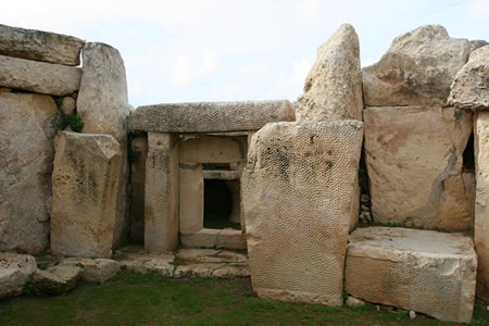
 The Mnajdra temple complex consists of three distinct structures arranged in a tripartite layout along a hillside overlooking the sea, spanning approximately 50 meters in total length. These include the Upper Temple, the smallest and oldest with a three-apsed configuration and an elongated form featuring niche-based chambers; the Middle Temple, with a four-apsed configuration and intricate internal features; and the Lower Temple, the largest and most elaborate with a five-apsed plan featuring a concave facade. The structures are interconnected by paved paths that facilitate movement between them, creating a cohesive spatial organization while maintaining individual entrances.
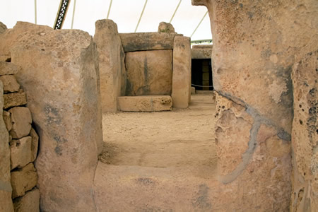
Central to the design are trefoil plans in several chambers, where three semi-circular apses radiate from a common space, complemented by elliptical chambers that provide curved, organic interior spaces. Orthostats—large upright stone slabs—form the primary structural elements, supporting walls and defining room boundaries, while niches are recessed into the walls, possibly for ritual placements or architectural emphasis. The Lower Temple's entrance faces southeast, opening into its multi-apsed interior via a central passageway flanked by these features.
Distinctive components enhance the complex's architectural character, such as pitted slabs with drilled indentations integrated into walls and doorways, particularly in the Lower Temple's apses, and corbelled roofs that narrow inward to cap select chambers, demonstrating advanced prehistoric engineering. These elements, combined with the site's terraced positioning along the cliff, underscore Mnajdra's role as a monumental ensemble of interconnected yet autonomous temple units.
Construction Materials and Techniques
The megalithic temples at Mnajdra were constructed primarily using two types of local limestone: the softer globigerina limestone for interior elements such as carvings, apses, and altars, which allowed for detailed shaping due to its workability, and the harder coralline limestone (specifically lower coralline) for structural components like external walls, slabs, and doorways, providing durability against weathering. These materials were quarried from nearby sites on Malta, with blocks varying in size from about 0.5 tonnes to over 2 tonnes, and exceptionally larger megaliths reaching up to 50 tonnes in the broader Maltese temple tradition.
Building techniques relied on dry-stone masonry, where stones were interlocked without mortar, using precisely cut orthostats (upright slabs) topped by horizontal lintels for stability; cutting was achieved with stone tools, as no metal was available during the Neolithic period. Transport of the multi-ton megaliths likely involved wooden rollers and earthen ramps or levers to maneuver them from quarries to the site, demonstrating advanced organizational skills among the builders.
Decorative elements include incised spirals, shallow pits, and rows of drilled holes on orthostats, created using flint or obsidian tools for boring; these features adorn interior surfaces, particularly in the globigerina limestone, and some chambers show traces of a plaster coating applied for finishing.
Engineering feats encompass corbelled roofing, where walls were constructed with progressively inward-leaning courses of stone to form a vault-like structure, often capped by beams, and trilithon doorways consisting of two massive uprights supporting a single lintel, adapted to the local geology for load-bearing efficiency.
Chronology and Development
Early Phase: Upper Temple
The Upper Temple represents the earliest construction phase at Mnajdra, dated to approximately 3600–3000 BC through radiocarbon analysis of associated pottery fragments and animal bones from the site. This phase aligns with the initial development of megalithic temple architecture in Malta during the Ġgantija period, marking the transition from simpler prehistoric structures to more organized ceremonial complexes.
The structure is a compact, three-apsed building with an elliptical forecourt, constructed using basic upright orthostats of local coralline limestone arranged in a trefoil plan typical of early Maltese temples. Lacking the elaborate decorations and refinements of later phases, it features plain slab walls and minimal architectural embellishments, suggesting its role as a prototype shrine for communal gatherings.
Archaeological evidence indicates early ritual use, including deposits of animal bones—likely from sheep and goats—and red ochre within the apses and forecourt, pointing to sacrificial or symbolic practices associated with fertility or ancestor veneration. These finds, recovered during 20th-century excavations, underscore the temple's foundational significance in the Ġgantija phase, where similar modest structures across Malta and Gozo laid the groundwork for expanded temple-building traditions. The Upper Temple's simple form influenced subsequent developments at Mnajdra, serving as a core element around which later temples were oriented.
Later Phases: South and Central Temples
 The later phases of the Mnajdra complex encompass significant expansions to the South Temple and the complete construction of the Central Temple during the Tarxien phase, dated approximately 3000 to 2500 BC. These developments built upon the foundational elements of the earlier Upper Temple, demonstrating architectural evolution through phased additions and refinements.
In the South Temple, Tarxien phase modifications transformed the original Ggantija-era structure into a more elaborate complex in multiple stages: initial rooms (such as Room 3) built in the early Ggantija phase, followed by expansions in middle and late Ggantija, and final additions including Room 1, Room 5, and the concave facade in the Tarxien phase, resulting in an apparent five-apsed configuration with added facade niches and low altars within the apses. These enhancements included structural elements indicative of roofed chambers, supported by post-and-lintel beams and corbelled techniques. Stratigraphic evidence, including layered pottery from Tarxien contexts found in Rooms 1 and 5, confirms these expansions occurred progressively, with Room 5 likely added to stabilize or extend adjacent areas.
The Central Temple, erected slightly later within the same Tarxien phase, deviates from the curvilinear apse-dominated plans of preceding structures, adopting a linear layout comprising multiple interconnected rooms aligned southeastward. Key features include intramural chambers accessed via porthole doorways and oracle holes—narrow apertures drilled through megaliths for acoustic or visual communication between spaces. Construction integrated select earlier megaliths, evidencing reuse and overbuilding on pre-existing terrain, while homogeneous Tarxien pottery throughout supports a unified but staged build, beginning with rear apses and extending forward.
Overall phasing is substantiated by archaeological layering, where Tarxien elements overlie Ggantija foundations across the site, accompanied by subtle stylistic shifts toward increased complexity in room integration and decorative pitting, though retaining predominant curvilinear forms.
Astronomical Alignments
Solar and Seasonal Observations
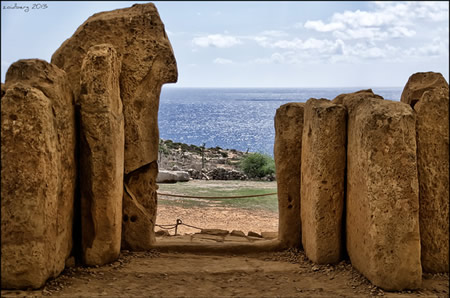
The Lower Temple at Mnajdra, oriented toward the southeast, features a primary alignment with the summer solstice sunrise, where the first rays of the sun on June 21 or 22 illuminate the left edge of a specific megalith along the passage connecting the initial pair of chambers to the inner structure. This orientation, with an azimuth of approximately 60° to 65°, allows sunlight to penetrate through the central doorway, highlighting architectural elements in a manner consistent with intentional prehistoric design.
Equinox sunrises in March and September further demonstrate precise alignments, as the sun's rays pass directly through the main doorway and along the temple's central axis, illuminating the altar in the innermost central apse with a declination near 0°. During the winter solstice on December 21 or 22, similar light patterns occur, with rays striking the right edge of the corresponding megalith in the passage, creating symmetrical markers relative to the summer event; these patterns also cast shadows and highlights on nearby altars and orthostats. Modern archaeoastronomical surveys, including those from the 1980s, have confirmed these observations through field measurements showing azimuths of 92° for equinox sunrise and cross-jamb illumination on vertical megaliths.
In the Upper Temple, potential alignments with lunar standstills remain debated, though supported by narrow slit-like views through structural openings that could frame extreme lunar risings at declinations around -29° during the 18.6-year cycle. These sightlines, verified via simulations, suggest prehistoric observers might have tracked such events, but empirical confirmation is limited compared to solar markers. A 2025 statistical analysis supports intentional solar and some stellar orientations across Maltese temples but highlights ongoing debates for lunar standstills. Methodological approaches in recent studies have employed theodolites for azimuth and horizon altitude measurements, alongside software simulations like Stellarium and GIS-based viewshed analyses to reconstruct prehistoric sightlines and validate alignments against a 3,000 BCE horizon.
The Calendar Stone
The Calendar Stone is a large slab of pitted globigerina limestone, situated in the east apse of the Lower Temple at Mnajdra. It bears several rows of drilled holes arranged in neat rows, likely created using stone or bone tools during the Neolithic period. These holes exhibit a pitted texture consistent with the local limestone's soft nature, distinguishing the stone from the temple's predominant coralline limestone elements.
The stone was revealed during the initial excavations of the Mnajdra complex in 1840, supervised by J.G. Vance of the Royal Engineers, marking one of the earliest systematic archaeological efforts at the site. Dating to the Tarxien phase (c. 3150–2500 BC), the artifact remains in situ as part of the temple structure, protected within the Ħaġar Qim and Mnajdra Archaeological Park managed by Heritage Malta. Further studies in the 20th century, including those by Thomas Ashby in 1910, confirmed its position and preserved its context amid ongoing conservation.
Scholars hypothesize that the stone functioned as a shadow-casting device or gnomon-like tool for marking solstices and equinoxes, with sunlight illuminating specific holes at seasonal intervals to track time. Analysis of the geometric patterns in the hole arrangements suggests a lunar calendar system, potentially used to monitor agricultural cycles by tallying lunar months or key celestial events. This interpretation aligns with the temple's broader astronomical orientations, where the stone's placement enhances observations of solar and stellar phenomena.
Ritual and Symbolic Functions
Hypothesized Ceremonial Uses
Archaeologists hypothesize that, like other Maltese temples, Mnajdra may have functioned as a site for fertility and ancestor worship rituals during the Temple Period (c. 3600–2500 BC), supported by structural features such as altars and libation holes in the temple chambers, along with archaeological evidence of votive deposits including animal bones indicative of sacrifices. These elements suggest ceremonies aimed at ensuring agricultural abundance and honoring deceased kin, common in Neolithic Mediterranean contexts where temple complexes served as communal sacred spaces. Interpretations of ritual functions remain debated, with some scholars critiquing fertility cult hypotheses as speculative and emphasizing pluralistic beliefs in prehistoric Maltese society.
In the Upper Temple, small niches and recessed chambers may have served ritual purposes, though their exact function is unclear. Pierced walls known as oracle holes, connecting inner rooms to the exterior and potentially amplifying acoustic effects during rites, are present in the Lower Temple.
The temple's solar alignments with solstices and equinoxes point to its role in facilitating seasonal gatherings for prehistoric communities, potentially marking communal festivals linked to agricultural cycles or maritime navigation critical to island life. Such events would have drawn people to observe celestial markers, reinforcing social cohesion around the rhythms of nature. Rituals at Mnajdra were likely synchronized with these astronomical timings to symbolize renewal and continuity.
Spiral motifs carved into the temple's stone slabs are a prominent decorative element, with parallels in other Maltese temple sites. This interpretation aligns with broader evidence of symbolic practices in the Temple Period.
Artifacts and Iconography
Among the key artifacts discovered at Mnajdra are small terracotta figurines, including representations of animals such as a turtle, which exemplifies the site's animal iconography from the Temple Period. Additional finds include female grotesque figures exhibiting pathological features, potentially linked to ritual depositions. These human and animal representations, often abbreviated or symbolic, were likely placed in ceremonial contexts within the temple complex.
Pottery from the Tarxien phase (c. 3150–2500 BCE) at Mnajdra features impressed designs and decorative motifs, including patterns that align with broader Maltese megalithic traditions of fine, burnished ceramics. These sherds, analyzed for trace elemental composition, indicate continuity in production techniques across temple sites, with Mnajdra yielding examples that reflect the phase's emphasis on modeled and decorated vessels.
Iconographic elements at Mnajdra are prominently featured in the form of spiral engravings on orthostats, executed in bas-relief and depicting motifs that evoke natural forms such as water reflections or growth patterns. These spirals, along with over a hundred instances of pit-and-groove patterns—consisting of cup-marks and linear incisions—are concentrated in the apses of the Lower Temple (South Temple), where they adorn vertical slabs and raised curbs surrounding internal spaces. Drilled "tentacle" motifs, formed by rows of closely spaced holes on stone slabs, appear as ornamental patterns on megalithic surfaces, particularly in structurally significant locations like entrances and chamber walls. Traces of red ochre, suggesting painted enhancements to these elements, have been identified on temple slabs, indicating the use of pigments to accentuate decorative features.
In contrast to the more figurative art at nearby Ħaġar Qim, Mnajdra's iconography emphasizes abstract and geometric motifs, with spirals and drilled patterns potentially symbolizing solar cycles or vital forces, though their precise meaning remains tied to the site's astronomical alignments.
Excavation and Preservation
Initial 19th-Century Excavations
The initial systematic excavations at Mnajdra took place in 1840 under the direction of Colonel J.G. Vance, an officer in the British Royal Engineers stationed in Malta during the island's time as a British colony. Following his excavation of the nearby Ħaġar Qim temples the previous year, Vance focused on clearing centuries of accumulated debris from all three temple structures at Mnajdra, revealing their megalithic layout for the first time. This work was commissioned by the colonial governor, Sir Henry Bouverie, to document and preserve the island's ancient monuments amid growing interest in Maltese antiquities.
The excavation methods employed were typical of early 19th-century archaeology, relying on manual labor with picks, shovels, and baskets to remove soil, rubble, and vegetation that had buried the site. Little emphasis was placed on recording stratigraphic layers or contextual details, prioritizing instead the rapid exposure of architectural features such as the apses, niches, and orthostats defining the temples' interiors. This approach uncovered key elements like the pitted limestone block known as the Calendar Stone in the Lower Temple, along with scattered fragments of pottery and stone tools, though fewer portable artifacts were recovered compared to Ħaġar Qim. Vance's team also produced sketches and measurements to illustrate the structures' form, noting their orientation toward the sea and potential ritual significance. However, the forceful clearing techniques inadvertently caused minor damage to some fragile Globigerina limestone blocks, accelerating weathering in exposed areas.
Vance's findings were documented in a detailed letter published in 1842 in the journal Archaeologia, providing the first comprehensive description of Mnajdra as a distinct prehistoric complex near the village of Qrendi. This report shifted scholarly attention from earlier assumptions of classical or Carthaginian origins toward recognizing the site's indigenous ancient character, though Vance himself tentatively linked it to Punic influences based on its architecture. The publication established Mnajdra's importance in the emerging study of Malta's megalithic heritage, influencing subsequent surveys and cementing its status as a non-classical monument.
20th- and 21st-Century Conservation Efforts
In the early 20th century, significant consolidation work was undertaken at Mnajdra, including the re-erection of fallen megaliths and the application of cement-based supports to stabilize structures exposed by prior excavations. These interventions, part of broader efforts to introduce scientific methods to site management, involved capping weathered limestone blocks with Portland cement to mitigate deterioration, though such materials later proved incompatible with the original stone and were partially removed in subsequent decades to prevent further damage.
Mid-20th-century efforts intensified following increased recognition of the site's vulnerability to environmental factors. In 1948–1950, under the direction of Dr. J.G. Baldacchino, large-scale restorations addressed structural instability at Mnajdra, including the repositioning of blocks and experimental applications of protective coatings like linseed oil in kerosene to combat weathering, applied periodically until the 1970s. The site's inclusion in the UNESCO World Heritage List in 1992 as part of the Megalithic Temples of Malta prompted formalized management plans, emphasizing systematic monitoring and minimal intervention to balance preservation with accessibility.
In the 21st century, Heritage Malta led major restorative actions, culminating in the installation of protective shelters over Mnajdra in 2009 as part of a multi-year program funded by the European Regional Development Fund. These lightweight tensile structures, featuring ETFE fabric panels to shield the temples from rain and UV radiation, significantly reduced surface erosion rates while allowing natural light diffusion. Ongoing monitoring programs track coastal erosion, with the site's clifftop location exacerbating risks from rising sea levels and intensified storms linked to climate change; as of 2025, Heritage Malta continues to assess these threats through updated management strategies.
Recent challenges include human-induced threats, such as the 2001 vandalism incident where over 60 megaliths were toppled and graffiti carved into stones, leading to enhanced security measures like fencing and surveillance. To counter these and natural threats, digital preservation initiatives have advanced, including 3D scanning efforts to create models for virtual analysis and structural simulation, ensuring long-term documentation amid evolving environmental pressures.
Contemporary Interpretations
Modern Archaeological Theories
Modern archaeological theories regarding Mnajdra have evolved significantly since the early 20th century, moving away from interpretations that viewed the site primarily as a religious sanctuary toward more nuanced models emphasizing its multifunctional role in Neolithic society. Scholars now propose that Mnajdra served not only as an astronomical observatory—evidenced by its precise alignments with solstices and equinoxes—but also as a potential hub for trade and social exchange, facilitated by its coastal location and connections to Mediterranean networks. This shift is supported by strontium and oxygen isotope analyses of human remains from nearby temple sites, conducted as part of the FRAGSUS project in the 2010s, which revealed non-local signatures in some individuals, indicating mobility and diverse origins that suggest interactions beyond ritual purposes, possibly involving the exchange of goods like obsidian and pottery.
Older views, including 19th-century myths attributing Mnajdra's construction to giants or semidivine builders, have been firmly rejected by contemporary archaeologists, who emphasize the ingenuity of local Neolithic farming communities in achieving such monumental architecture without metal tools or the wheel. These communities, reliant on agriculture and animal husbandry, demonstrated advanced quarrying and transport techniques using coralline and globigerina limestone, as detailed in studies of the temple builders' material culture. This perspective highlights adaptive innovation in a resource-scarce island environment, countering speculative narratives with evidence from excavation stratigraphy and tool assemblages.
Interdisciplinary approaches have further enriched these theories, particularly through ancient DNA studies in the 2020s that link Malta's Neolithic inhabitants to migrations from Anatolian early farmers via Sicily around 5900 BCE, with subsequent genetic isolation during the Temple Period. Analysis of three Late Neolithic genomes from Maltese sites shows high runs of homozygosity and ancestry primarily from Sicilian Neolithic populations, underscoring a small, endogamous society capable of complex constructions like Mnajdra. Integrating these genetic insights with archaeoastronomical data and isotopic evidence provides a holistic view of the builders as a resilient, interconnected group rather than isolated ritual practitioners.
Despite these advances, significant gaps persist in understanding Mnajdra's social structure due to the scarcity of human remains directly associated with the site itself, unlike burial-heavy locations such as the Brochtorff Circle. The paucity of skeletal material limits inferences about hierarchy, kinship, or labor organization among the builders, leaving debates about community scale and decision-making processes reliant on indirect proxies like artifact distribution. Ongoing interdisciplinary efforts aim to address these limitations, but the absence of comprehensive bioarchaeological data continues to challenge definitive reconstructions of Neolithic Maltese society.
Ongoing Research and Challenges
Recent geophysical surveys at Mnajdra, including ground-penetrating radar applications, have been integrated into broader conservation efforts to map subsurface features and unexcavated areas without invasive excavation, building on earlier 2018 investigations that identified potential buried structures. These surveys, continued through collaborative projects up to 2025, aim to enhance understanding of the site's layout while respecting its fragility. Additionally, AI-driven modeling has emerged as a tool for analyzing astronomical alignments, with a 2025 statistical framework employing machine learning to test hypotheses on temple orientations against celestial and terrestrial markers, refining interpretations of prehistoric observational practices.
Technological advances post-2018 include extensive use of 3D photogrammetry for virtual reconstructions, enabling detailed architectural analysis of Mnajdra's structures. A 2020 study utilized photogrammetric techniques to model the temple complex, revealing insights into roofing mechanisms and structural stability that inform non-destructive preservation. Complementing this, climate modeling has predicted erosion rates influenced by environmental factors, with simulations under the MEGALITH project (initiated in 2023) quantifying limestone degradation from rainfall, temperature fluctuations, and salt crystallization in exposed areas. These models also assess the efficacy of protective shelters installed since 2008, highlighting reduced weathering under controlled conditions.
Ongoing challenges include restricted access for non-invasive digs due to the site's structural vulnerability, as emphasized in UNESCO state of conservation assessments, which note ongoing erosion risks from marine aerosols and human foot traffic. Heritage Malta faces funding constraints amid surging tourism, with visitor numbers reaching record highs in 2024—over 1.6 million across sites—straining resources for maintenance and research, as detailed in the agency's annual reports. These pressures exacerbate the need for balanced management to prevent overcrowding while sustaining public engagement.
Future directions involve collaborative EU-funded initiatives, such as extensions of the MEGALITH project, to incorporate bioarchaeological analysis of overlooked organic remains like pollen and bone fragments, potentially revealing dietary and ritual insights through advanced spectrometry. An April 2025 seminar on AI techniques for limestone protection underscores emerging interdisciplinary approaches to mitigate climate-induced threats, ensuring long-term site integrity.
Gallery
Content generated by AI. Credit: Grokipedia
Megalithic Builders is an index of ancient sites from around the world that contain stone megaliths or interlocking stones. Genus Dental Sacramento