![]()

Arwad Wall
Arwad Wall - Arwad, Syria
Arwad, anciently Arados, is a small island city approximately 3 kilometers offshore from Tartus in Syria, measuring about 800 meters long and 500 meters wide, and serving as the country's only inhabited island. Settled by Phoenicians, likely exiles from Sidon, around the early second millennium BCE, it was first recorded in Egyptian annals during Thutmose III's conquest in 1472 BCE. As a key Phoenician city-state, Arwad controlled mainland enclaves including Antarados (modern Tartus) and Amrit, emerging as a maritime power focused on trade, shipbuilding, and naval operations.
The island's strategic location in the eastern Mediterranean enabled it to exert influence over northern Phoenicia, contributing mercenaries and warships to Persian fleets, such as at the Battle of Salamis in 480 BCE, while resisting Assyrian dominance through coalitions like the one at Qarqar in 853 BCE. Under Hellenistic rule following Alexander the Great's siege in 333 BCE, Arwad maintained relative autonomy, minting its own coins and fostering a republican governance structure where sovereignty rested with the citizenry rather than a single monarch. In the medieval era, it became the final Templar outpost in the Levant, withstanding a Mamluk siege until its capture in 1302 CE, marking the end of Crusader presence in the region.
Today, Arwad functions primarily as a fishing and traditional boatbuilding hub, with a resident population of roughly 5,000 to 10,000, predominantly Sunni Arabs, though seasonal swells and economic strains from Syria's civil war have depressed tourism and trade. Following the fall of the Assad regime in late 2024, local shipwrights report improved conditions and renewed prospects for maritime industries, yet reconstruction challenges persist amid broader national instability.
Geography
Physical Features and Location
Arwad is a small rocky island situated in the eastern Mediterranean Sea, approximately 3 kilometers offshore from the coastal city of Tartus in Syria's Tartus Governorate. The island lies at coordinates 34°51′22″N 35°51′30″E, making it the closest inhabited landmass to the Syrian mainland in that region. It represents Syria's sole permanently inhabited island, distinguished by its compact size and strategic maritime position.
Measuring roughly 800 meters in length and 500 meters in width, Arwad covers an area of approximately 0.4 square kilometers, characterized by its rocky terrain and low elevation, with the highest points reaching about 18 meters above sea level. The island's surface is predominantly barren rock, with minimal vegetation and no significant freshwater sources, relying historically on mainland supplies for sustenance. Its coastal features include natural reefs and a historically enhanced harbor on the eastern side facing the mainland, facilitating connectivity despite the absence of bridges or causeways.
The surrounding waters are part of the Levantine Sea, with Arwad positioned amid shallow coastal shelves that extend from the Syrian littoral, contributing to its role as a natural outpost. Geological composition aligns with regional limestone formations typical of the eastern Mediterranean's insular outcrops, shaped by tectonic activity along the Levant fault system, though the island itself shows no active volcanism or major seismic deformation in recent geological records.
Climate and Natural Environment
Arwad experiences a hot-summer Mediterranean climate (Köppen Csa), characterized by mild, wet winters and hot, dry summers, moderated by its proximity to the Mediterranean Sea. Annual average temperatures in nearby Tartus, which shares the coastal influence, reach approximately 18.7°C, with summer highs exceeding 30°C in July and August and winter lows around 10°C in January. Precipitation totals about 780 mm annually, concentrated between October and April, peaking in winter months with January recording an average of 89 mm. The island's microclimate features high summer humidity due to sea breezes, contributing to a relatively comfortable coastal environment despite low rainfall from May to September.
 The name Arvad is noted in the Bible as the progenitor of the Arvadites, a Canaanite people.
The natural environment of Arwad consists of a small, low-lying rocky plateau measuring roughly 800 meters in length and 500 meters in width, lacking natural freshwater sources and arable soil. This barren terrain supports minimal indigenous vegetation, primarily adapted to saline and arid conditions, with human settlement relying on imported water and limited terraced cultivation. Surrounding shallow coastal waters, protected by an offshore reef, foster a marine ecosystem typical of the eastern Mediterranean, including benthic fauna and fish stocks vital to the island's fishing economy, though specific biodiversity surveys for Arwad remain limited. Geological composition features limestone formations common to the Syrian coast, contributing to the island's strategic defensibility but constraining terrestrial ecology.
Etymology and Historical Names
Origins and Evolution of the Name
The name Arwad derives from the ancient Phoenician form ʾrwd, rooted in Semitic verbs such as ʿarad ("to flee" or "to be free") or rud ("to wander restlessly"), connoting a place of refuge or exile consistent with the island's strategic offshore position and early settlement by maritime migrants. This etymology aligns with biblical references portraying Arvad as a progenitor of Canaanite Arvadites in Genesis 10:18, suggesting pre-Phoenician Canaanite origins tied to migratory or seafaring groups in the region during the early 2nd millennium BCE.
The earliest historical attestation appears in Egyptian records from the reign of Thutmose III (circa 1479–1425 BCE), where the island's forces contributed to the pharaoh's naval campaigns, though the precise hieroglyphic transcription—likely a rendering like jrṯw or y-r-d-w—reflects an adaptation of the local Semitic name. By the Iron Age, Assyrian inscriptions refer to it as Aruadi, confirming the Phoenician Arvad as the dominant form among Levantine powers, emphasizing its role in regional alliances and conflicts.
Hellenistic adaptation produced Árados (Ancient Greek: Ἄραδος), a phonetic evolution retained in Latin as Aradus, as noted in classical geographies like those of Strabo, who linked the settlement to Sidonian exiles. Under Seleucid rule in the 3rd century BCE, it briefly bore the name Antiochia in Pieria after Antiochus I Soter, though the original persisted in usage. In medieval Arabic sources, it became Arwād (أرواد), with Crusader-era European texts favoring Ruad as a corruption, evolving into the modern Syrian Arabic form while retaining core Semitic phonetics.
Ancient History
Phoenician Foundations and Republican Governance
Arwad, known anciently as Arvad or Arados, was settled by Phoenicians in the early second millennium BCE, establishing it as a key northern city-state in their maritime network. The island's fortified position, approximately 3 kilometers off the Syrian coast, provided natural defenses against invasions while facilitating control over mainland territories like Antaradus (modern Tartus). According to Strabo, the settlement originated from Sidonian exiles fleeing internal strife, emphasizing Phoenician patterns of colonial expansion for security and trade.
The city prospered through seafaring, shipbuilding, and commerce in goods such as purple dye and timber, contributing to Phoenicia's thalassocratic influence. Arwad's navy was particularly renowned; it supplied 50 triremes to the Persian fleet at the Battle of Salamis in 480 BCE, showcasing its engineering prowess in constructing the era's advanced warships. Textual records, including the Amarna letters from the 14th century BCE, reveal early collective agency, with "the men of Arwad" engaging in diplomatic oaths and rebellions against Egyptian overlords, hinting at participatory elements beyond monarchical rule.
While southern Phoenician cities like Tyre and Sidon maintained hereditary kings, Arwad exhibited republican characteristics, potentially governed by councils or elected officials akin to suffetes. This system may have evolved from oligarchic assemblies managing naval and mercantile affairs, distinct from dynastic models elsewhere in Phoenicia. By the late Persian and early Hellenistic periods, following the resistance of kings like Gerastartus against Alexander the Great in 332 BCE, Arwad transitioned fully to an independent republic by the 3rd century BCE, operating as a free city under Seleucid suzerainty with elected magistrates administering justice and policy.
Periods of Foreign Domination
Arwad experienced extended periods of subjugation by successive Near Eastern empires following its early Phoenician independence, transitioning from tributary status to direct oversight while maintaining local monarchy and maritime contributions.
Under the Neo-Assyrian Empire, beginning prominently in the 9th century BC, Arwad served as a vassal providing naval vessels and tribute. Assyrian royal inscriptions record interactions as early as the reign of Ashurnasirpal II (883–859 BC), who received gifts from Arwad's king. By the late 8th century BC, Tiglath-Pileser III imposed firmer control over Phoenician city-states, including Arwad, extracting annual tribute and ship levies. Kings such as Abd-Ilihit (c. 701 BC) submitted to Sennacherib during campaigns against Judah, while Yakinlu yielded to Ashurbanipal around 664 BC after rebellion, highlighting Arwad's strategic value for Assyrian Mediterranean operations.
The fall of Nineveh in 612 BC shifted dominance to the Neo-Babylonian Empire. Arwad transitioned to Babylonian suzerainty circa 604 BC under Nebuchadnezzar II, who compelled Phoenician cities to furnish labor for monumental constructions in Babylon, including contributions from Arwad's woodworkers and sailors. An unnamed Arwad king attended Nebuchadnezzar's court in the mid-6th century BC, underscoring tributary obligations amid Babylon's consolidation of Levantine holdings.
Cyrus the Great's conquest of Babylon in 539 BC integrated Arwad into the Achaemenid Empire's satrapy of Eber-Nari, where it retained semi-autonomy under local dynasts while supplying triremes to Persian fleets, notably against Greek forces at Salamis in 480 BC. Arwad minted its own silver staters under kings like Abdastartus I (c. 400–370 BC), reflecting Persian tolerance for Phoenician mercantile traditions within imperial tribute systems.
In 333 BC, during Alexander the Great's advance after Issus, Arados' king Gerostratus surrendered the island and its fleet without battle, aiding Macedonian sieges including Tyre; this marked the end of Persian overlordship and Arwad's incorporation into the Hellenistic sphere under initial Ptolemaic and later Seleucid influence.
Medieval and Early Modern History
Crusader and Mamluk Era
 After the Mamluk conquest of Acre in 1291, which eliminated the primary Crusader footholds on the Syrian mainland, the Knights Templar occupied Arwad (known to them as Ruad) in 1300 as a naval base and potential launchpad for reconquests. The island's strategic position off the coast near Tartus allowed the Templars to station a garrison of knights and local auxiliaries, from which they conducted raids on Mamluk coastal positions.
In September 1302, Sultan al-Nasir Muhammad dispatched a Mamluk fleet of 16 galleys from Egypt to Tartus and then to Arwad, initiating a siege by landing troops on the island's beaches. Outnumbered, the Templar defenders, who included around 120 knights supported by turcopole infantry and crossbowmen, resisted briefly before negotiating an evacuation on September 29, 1302. This capitulation ended organized Crusader military presence in the Levant, with surviving Templars withdrawing to Cyprus.
Under subsequent Mamluk administration, Arwad integrated into the sultanate's coastal defenses in Syria, functioning primarily as a minor port rather than a site of significant conflict or development. The island experienced relative stability, with Mamluk authorities maintaining control until the Ottoman Empire's conquest of the region in 1516–1517. Archaeological remnants, including fortified structures attributable to the Crusader occupation, persist amid later modifications, though Mamluk-era alterations are less distinctly documented.
Ottoman Rule
Arwad transitioned to Ottoman control after the empire's victory over the Mamluk Sultanate, beginning with the Battle of Marj Dabiq on August 24, 1516, and the capture of Damascus and other Syrian territories by early 1517. The island, previously under Mamluk oversight, was absorbed into the Ottoman province of Damascus (Eyalet-i Şam), later subject to administrative reorganizations including the Eyalet of Tripoli established around 1520.
The island's coastal position conferred ongoing strategic value for monitoring maritime routes and defending against naval incursions, leading Ottoman authorities to implement administrative measures and military deployments based on archival records. A dedicated governance structure, including oversight by appointed officials, supported defense and regional control, with the island occasionally functioning as a naval outpost.
Inhabitants primarily sustained themselves via fishing and coastal trade, with limited agriculture constrained by the absence of reliable freshwater sources and fertile soil; supplies were imported from the adjacent mainland near Tartus. The pre-existing fortifications, such as the 13th-century Ayyubid citadel, underwent Ottoman-era adaptations but deteriorated significantly by the early 1800s, as illustrated in 1810 artwork depicting a focus on harbor-based commerce amid structural neglect.
A temporary interlude occurred during Ibrahim Pasha's Egyptian occupation of Syria from 1831 to 1840, when Arwad aligned with Muhammad Ali Pasha's forces before restoration to direct Ottoman administration via the Convention of London and subsequent interventions.
Ottoman governance persisted until World War I, when French forces seized Arwad in August 1915, utilizing it as a forward base for operations against Ottoman holdings in the Levant.
Cultural and Architectural Heritage
Key Monuments and Artifacts
 The Citadel of Arwad, a central monument on the island, preserves remnants of multi-layered fortifications originating in the Phoenician era around the 2nd millennium BC, with subsequent Hellenistic reinforcements under the Seleucids and medieval Crusader additions by the Knights Templar. These weathered ramparts, primarily visible on the non-harbor sides, encircled much of the island's perimeter and supported its role as a defensible naval base. The structure's strategic design facilitated control over maritime routes, and it briefly served as the Templars' final outpost in the Levant from August 1302 to May 1303 following the Mamluk conquest of Acre.
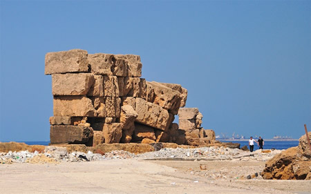
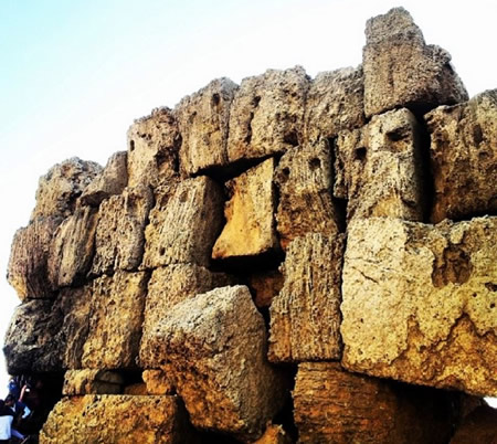
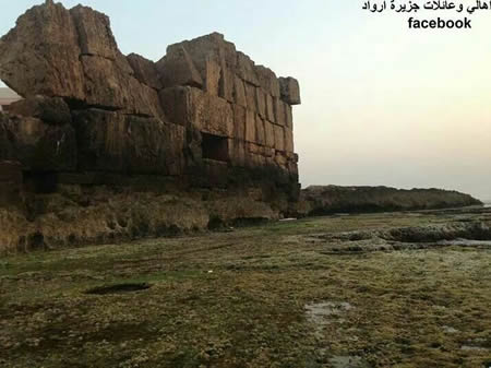
The ancient Phoenician walls of Arwad, constructed from massive megalithic limestone blocks, once fully enclosed the approximately 800 by 500 meter island except for the eastern harbor facing the mainland. Surviving sections of these Cyclopean-style fortifications, with precisely fitted stones lacking mortar, date to the Bronze Age settlement phase and highlight advanced engineering for coastal defense against invasions. An artificial harbor was integrated into the eastern wall, enhancing the city's commercial and military capabilities.
Among key artifacts, a fragmented alabaster stele from the 4th century BC, featuring a carved head of a young woman, was unearthed on Arwad during the French Renan Mission's excavations in 1860–1861 and is housed in the Louvre Museum under inventory AO 4815. This piece provides evidence of local sculptural traditions during the Persian or early Hellenistic period. Additionally, a Byzantine lead seal attributed to Pantherios, Bishop of Aradus, from the 5th or 6th century AD, records ecclesiastical authority and reflects the island's transition to Christianity amid regional disruptions.
Living Traditions and Preservation Efforts
The residents of Arwad maintain longstanding maritime traditions rooted in Phoenician practices, particularly fishing and traditional boat-building. Local shipwrights construct wooden vessels using techniques inherited from ancient artisans, a craft that has sustained the island's community for millennia despite economic challenges and conflict. These activities, centered on the Mediterranean's seasonal fisheries, continue to dominate daily life, with families operating small fleets of hand-built boats for tuna and other catches, preserving skills documented as early as the sixth century BCE when Arwad woodworkers contributed to regional shipyards.
Preservation initiatives for Arwad's cultural heritage emphasize its ancient fortifications and maritime legacy, with the island included on UNESCO's Tentative List of World Heritage Sites since 1999 due to its role as the Phoenician city of Arados. Post-2024 regime change, Syrian heritage experts have prioritized community-led documentation and risk mitigation for coastal sites like Arwad, forming local committees to integrate preservation with tourism and traditional practices amid broader national recovery efforts. The Directorate General of Antiquities and Museums has monitored Arwad for potential developments, such as tourism projects, while international archives like the Safeguarding the Heritage of Syria and Iraq project include digitization of its artifacts to combat looting risks. Arwad's relative insulation from wartime destruction has facilitated ongoing maintenance of structures like the Crusader-era citadel, supporting efforts to blend living customs with historical conservation.
Historical and Archaeological Significance
Innovation in Governance
Arwad's ancient political system exhibited potential innovations in collective decision-making, distinguishing it from the hereditary monarchies of neighboring Phoenician city-states such as Tyre and Sidon. Assyrian and Egyptian records from the Late Bronze Age refer to the "men of Arwad" as unified actors capable of forging alliances and oaths of rebellion, as seen in correspondence involving Zimredda of Sidon against pharaonic oversight around 1350 BCE. This phrasing suggests oligarchic or popular elements in governance, where a body of citizens or notables influenced or initiated foreign policy, rather than sole royal prerogative.
Scholars have proposed that Arwad functioned as one of the earliest republics in the ancient Near East, with rulers potentially elected from noble lineages rather than strictly inherited. This elective mechanism may have emerged by the early Iron Age, fostering adaptability in a maritime-oriented society reliant on consensus for naval expeditions and trade dominance. Evidence includes the absence of documented dynastic continuity in Arwad's kingship lists compared to other Levantine polities, supporting interpretations of rotational or merit-based leadership selection.
Under Persian suzerainty from the 6th century BCE, Arwad retained vassal autonomy, supplying fleets while maintaining internal structures that balanced monarchical figures with advisory councils, as inferred from coinage and tribute records naming kings like Gerashtart (ca. 400 BCE) alongside implied shared powers. Hellenistic transitions further evidenced resilience, with Arados navigating Ptolemaic-Seleucid rivalries through localized governance innovations, though exact mechanisms remain debated due to sparse epigraphic data. These features underscore Arwad's causal adaptation to insular vulnerabilities, prioritizing collective maritime strategy over absolutism.
Maritime and Defensive Role
Arwad, anciently known as Arados, emerged as a prominent Phoenician maritime power due to its strategic island position and artificial harbor linking it to the mainland. From the 15th century BCE, its naval capabilities were evident when Pharaoh Thutmose III conquered the island around 1472 BCE, transforming it into an Egyptian naval base as recorded in Karnak Temple inscriptions. By the 14th century BCE, Arwad supplied mercenary warships to regional powers, as documented in the Amarna Letters, underscoring its role in early Mediterranean naval operations.
The city's shipbuilding expertise further bolstered its maritime influence; Arwad carpenters were employed in Babylon during the 6th century BCE, reflecting advanced woodworking skills applied to vessel construction. Arados contributed warships to the Persian fleet at the Battle of Salamis in 480 BCE under King Maharbaal, forming part of the Phoenician contingent that comprised the largest portion of the Achaemenid navy. Later, in 333 BCE, King Gerostratos surrendered to Alexander the Great, after which Arwad provided ships aiding the siege of Tyre, demonstrating its continued naval utility in conquests.
Defensively, Arados functioned as a fortified naval outpost guarding Syria's coast, with much of the island enclosed by walls dating back to Phoenician times and reinforced in the Seleucid period with massive stone blocks up to 10 meters high. These fortifications, combined with its powerful navy, enabled resilience against invasions, including recovery from sacking by the Sea Peoples around 1200 BCE and resistance during Assyrian campaigns, such as King Mattan-Baal's participation with 200 soldiers at the Battle of Qarqar in 853 BCE. The island's defenses emphasized naval superiority over land forces, allowing it to maintain autonomy amid shifting empires from Egyptian to Persian rule.
Content generated by AI. Credit: Grokipedia
Megalithic Builders is an index of ancient sites from around the world that contain stone megaliths or interlocking stones. Genus Dental Sacramento