![]()

Plain of Jars
Plain of Jars - Xiangkhouang, Laos
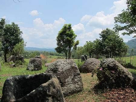
The Plain of Jars is a megalithic archaeological landscape comprising over 2,100 large tubular stone jars, quarried from sandstone, scattered across more than 90 sites on a plateau in central Laos' Xiangkhoang Province. These jars, ranging from 1 to 3 meters in height and weighing up to 6 tons, were primarily used for secondary funerary practices, as evidenced by associated human remains, burial goods, and cave mortuaries in the vicinity. Radiocarbon dating of organic materials from excavations indicates construction between approximately 1240 and 660 BCE, aligning with the late Bronze Age to early Iron Age transition rather than the previously assumed later Iron Age period. Inscribed as a UNESCO World Heritage Site in 2019, the complex represents a rare example of prehistoric megalithic tradition in Southeast Asia, though debates persist on details of ritual use beyond mortuary functions due to limited inscriptions or textual records.
The site's jars, often arranged in clusters atop hills or plateaus, feature carved human figures and geometric motifs on some lids and discs, suggesting cultural symbolism tied to ancestor veneration or communal ceremonies. Archaeological evidence, including burnt bones and ceramics within and near jars, supports interpretations of distillation for secondary burial rites, where remains were exposed, processed, and interred, countering unsubstantiated local legends of giant brews or rice wine fermentation that lack empirical backing. Systematic surveys since the 1930s, hampered by post-Vietnam War unexploded ordnance contamination from U.S. bombings—estimated at 270 million submunitions dropped, leaving up to 30% unexploded—have only recently enabled comprehensive clearance and excavation at key sites like Site 1 near Phonsavan.
Despite ongoing hazards that restrict access and endanger researchers, international collaborations have advanced understanding, revealing the Plain of Jars as part of broader regional megalithic networks linking to Vietnamese dong son culture influences, emphasizing empirical osteological and stratigraphic data over speculative narratives. Its preservation challenges underscore causal factors like wartime legacies, yet the site's integrity as a testament to ancient engineering—jars transported kilometers from quarries—highlights resilient cultural continuity in a geopolitically isolated region.
Geography and Location
Topographical and Environmental Context
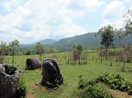
The Plain of Jars is located on the Xiangkhoang Plateau in Xiengkhuang Province, central Laos, a dissected upland region at elevations averaging approximately 1,100 meters above sea level. This plateau forms a western extension of the northern Annamite Range, characterized by rolling hill slopes, spurs, and central plains that surround the jar sites.
Geologically, the area features complex structures of limestone and sandstone hills, contributing to a rugged terrain with upland valleys and lower foothills suitable for ancient quarrying activities. The karst-influenced landscape, marked by carbonate bedrock, supports thin soils prone to weathering, while the tropical monsoon climate delivers heavy seasonal rainfall from May to October, fostering lush vegetation but also accelerating erosion processes that challenge site stability.
The jar sites lie in close proximity to Phonsavan, the provincial capital, with the main cluster at Site 1 situated about 10 kilometers from the town center, enabling relatively straightforward access amid the plateau's undulating topography. Over recent decades, extensive deforestation driven by agricultural expansion has altered the original forested environment; for example, from 2021 to 2024, Xiangkhoang Province recorded 92.7 thousand hectares of natural forest loss, intensifying soil erosion risks on the limestone-derived substrates and impacting the preservation of exposed megalithic features.
Distribution of Sites
 The megalithic jar sites of the Plain of Jars extend across the Xiangkhouang Plateau in central Laos, primarily within Xieng Khouang Province, with extensions into Xaisomboun and Luang Prabang provinces, covering hundreds of square kilometers. As of 2023, surveys have documented 124 geo-located jar sites, comprising over 120 megalithic jar locations in total, distributed among hills, slopes, and spurs surrounding the central plateau. These sites collectively contain more than 2,100 stone jars, with individual clusters varying from a single jar to nearly 400.
Site density is highest in the central plateau regions near Phonsavan, where the most prominent clusters—designated as Sites 1, 2, and 3—are concentrated and attract the majority of archaeological attention and visitation. These core areas feature denser groupings of jars compared to peripheral zones, where sites become sparser and more isolated amid mountainous foothills. The uneven distribution reflects logistical constraints of ancient transport, as jars were quarried from local sandstone sources and moved short distances to placement locations, with unfinished jars and quarry outcrops often found in proximity to finished clusters. This pattern indicates that resource availability, particularly access to workable sandstone deposits, played a primary role in determining site locations rather than uniform environmental suitability across the plateau.
Archaeological Description
Characteristics of the Stone Jars
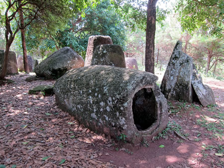
The stone jars comprising the Plain of Jars are predominantly carved from sandstone, though specimens of granite, conglomerate, and calcified coral also occur. These megalithic structures adopt tubular forms with narrow bases and wide mouths, measuring 1 to 3 meters in height and up to 1.5 meters in diameter at the opening. Individual jars weigh between several hundred kilograms and 14 tons for the heaviest examples.
At Site 1, the largest jar—referred to as the "Grandfather Jar" or "King Jar"—reaches approximately 3 meters in height and exceeds 1 meter in width, exemplifying the upper range of jar dimensions. Variations among the jars include differences in base shape, with some rounded and others angular, alongside decorative elements such as carved anthropomorphic faces, geometric patterns, and animal motifs on select specimens. Stone discs, numbering in the dozens across sites, exhibit shapes and sizes compatible with the jar mouths and are interpreted as potential lids.
The distribution of jar sizes, from smaller 1-meter examples to the 3-meter giants, indicates a degree of standardization in production alongside variability suited to different scales, though precise metrics derive from field measurements at cleared sites. Over 2,100 such jars have been documented, with clusters revealing patterns in size clustering by location.
Associated Megalithic Features
The associated megalithic features at Plain of Jars sites include stone discs, quarries containing unfinished jars, and megalithic grave markers, integrated into the archaeological landscape alongside the primary jar clusters. Across the 59 documented jar sites, 207 stone discs have been recorded, typically distributed near concentrations of jars, varying in size from approximately 50 cm to 1 meter in diameter and often featuring central perforations or carvings. These discs, carved from similar local sandstone or laterite as the jars, appear in varying densities; for example, Jar Site 3 exhibits a higher proportion of discs relative to jars compared to Sites 1 and 2.
Quarries represent key production-related features, with unfinished jars left in situ at various carving stages, demonstrating on-site extraction and initial shaping from bedrock outcrops. Notable examples include quarry sites near Jar Sites 2 and 3, such as Site 8, which comprises four distinct groups of partially hewn jars embedded in the quarry face, alongside tool marks and debris indicative of ancient extraction techniques. In total, 2,107 jars—both finished and unfinished—have been identified across the plateau, with quarries clustered in the Xieng Khouang region, often within 5-10 kilometers of primary deposition sites.
Megalithic grave markers, numbering 672, consist of upright boulders or discoid stones positioned at certain sites, sometimes aligned with jar arrangements or secondary burial contexts. Excavations at these features have yielded associated artifacts such as pottery sherds, iron tools, and glass beads, with radiocarbon dates from organic remains confirming Iron Age contexts spanning roughly 500 BCE to 500 CE. Cave systems proximate to some jar clusters, particularly in limestone karst areas, contain megalithic elements like modified boulders, though systematic documentation remains limited due to terrain and access challenges.
Construction and Chronology
Materials and Manufacturing Techniques
The megalithic jars were primarily carved from local sandstone deposits, with secondary use of granite, conglomerate, limestone, and calcified coral sourced from nearby outcrops and bedrock formations. These materials reflect the geological composition of the Xiangkhoang Plateau, where suitable stone was abundant and required minimal long-distance procurement.
Quarrying occurred at dedicated sites featuring unfinished jars still embedded in or adjacent to parent rock, demonstrating extraction via direct bedrock carving rather than transport of raw boulders. These incomplete forms, including preforms lacking interior cavities, illustrate sequential manufacturing stages: initial rough outlining and detachment from the quarry face using pounding with hard stone hammers or hammerstones, followed by progressive shaping. Experimental analyses confirm that lithic tools alone could achieve the necessary detachment and preliminary hewing, producing characteristic fracture patterns observed on jar exteriors without reliance on metal implements.
Finer finishing involved chiseling or abrasion to refine exteriors and excavate interiors, yielding jars with varying degrees of polish—some left rough-hewn, others smoothed. Pointed stone or early metal chisels likely aided in cavity formation post-quarrying, as evidenced by tool marks and replicative studies aligning with regional prehistoric lithic traditions. The scale of operations, involving jars up to 3 meters in height and weighing several tons, implies coordinated labor for on-site reduction and any necessary short-distance relocation using levers or rudimentary sledges.
Dating Evidence and Timeline
Radiocarbon dating of charcoal samples and human skeletal remains associated with the jar sites has yielded a range of dates, with the majority indicating activity from the Iron Age (approximately 500 BCE to 500 CE), though some outliers extend to as early as 8200 BCE and as late as 1200 CE; however, these extremes are not representative of primary jar emplacement. More specifically, excavations at Site 1 revealed burials dated to the 9th–13th centuries CE via radiocarbon analysis of remains and associated charcoal, suggesting prolonged post-emplacement use.
 Optically stimulated luminescence (OSL) dating of sediments beneath the jars provides direct evidence for initial placement, with samples from Site 2 indicating positioning as early as the late second millennium BCE (1240–660 BCE), potentially aligning with late Bronze Age or transitional periods in Southeast Asia. This pushes back the conventional Iron Age timeline (500 BCE–500 CE) for jar production and deployment, though U/Pb zircon dating of quarry materials supports sandstone sourcing contemporaneous with OSL results, without evidence for significantly earlier origins. Excavation stratigraphy across sites reveals multi-phase deposition, including layered artifacts consistent with sequential activity from the first millennium BCE through historic periods, but no verified pre-second millennium BCE phases.
The combined geochronological data thus establishes a timeline of jar emplacement initiating around 1240–660 BCE at select sites, with broader production and use spanning the Iron Age and extending into medieval times via secondary activities, confirmed by cross-validation of radiocarbon, OSL, and stratigraphic methods. These findings, derived from peer-reviewed analyses since 2020, refine prior assumptions and highlight phased development without indicating monolithic construction eras.
Interpretations of Purpose
Primary Hypothesis: Funerary Use
The primary hypothesis interprets the stone jars of the Plain of Jars as mortuary vessels employed in secondary burial practices, where defleshed or cremated human remains were interred following initial decomposition or excarnation. This view is grounded in archaeological excavations uncovering human skeletal elements directly associated with the jars across multiple sites. Evidence includes fragmentary bones, teeth, and cremated remains found inside jars or buried beneath them, consistent with ritualistic handling of the deceased rather than primary inhumation.
At Site 1, excavations revealed secondary burials comprising teeth and long bone fragments in pits adjacent to jars, alongside an urn with human bones and teeth positioned under a large jar. Cremated human remains have also been documented within some jars at this location, accompanied by charcoal deposits suggestive of funerary pyres. These discoveries indicate selective collection and placement of post-mortem remains, aligning with practices observed in regional megalithic traditions.
Further support comes from Site 75, where preliminary digs in 2023 yielded uncremated human remains inside a stone jar, marking the first substantive instance of such primary or secondary containment in Lao jar contexts and dated to approximately the 9th–12th centuries CE. Although the volume of human remains recovered remains limited—typically fragmentary and from few individuals per site—the consistency across excavations underscores a patterned funerary function.
This hypothesis draws comparative parallels to jar burial customs in island and mainland Southeast Asia, such as those in Borneo and the Philippines, where large vessels housed secondary interments after exposure or cremation to facilitate bone cleaning and ancestral veneration. In the Plain of Jars context, the jars likely served analogous roles, with associated megalithic features like stone discs and discs potentially aiding in covering or marking interments. The scarcity of complete skeletons and emphasis on disarticulated elements reinforces secondary burial as the dominant mechanism, distinct from contemporaneous primary grave traditions elsewhere in the region.
Alternative Theories
One hypothesis posits that the jars served as vessels for fermenting rice wine during communal rituals or to commemorate victories, drawing from local folklore attributing their construction to a giant king named Khun Cheung who brewed alcohol to celebrate conquests. This idea lacks empirical support, as no organic residues indicative of fermentation—such as yeast byproducts or rice starch—have been detected in analyses of jar interiors, despite excavations uncovering human remains and burial goods instead. Furthermore, the jars' upright orientation and association with nearby bones and discs align more causally with containment of remains than with liquid processing, where spillage or evaporation would render such features inefficient.
 Another proposal suggests the jars functioned for rainwater collection to supply travelers along ancient routes, given their placement on elevated plateaus. This encounters practical challenges: the jars' massive capacities (up to 6 cubic meters) and scattered distribution across non-arid sites exceed needs for portable storage, while lids and covers imply sealed rather than open catchment use; hydrological reasoning indicates smaller, localized pits would suffice without megalithic effort.
Speculation on astronomical alignments, akin to other megalithic sites, has been raised informally but remains unverified, with no documented orientations correlating to solstices or stars via surveys. Claims of construction by giants, rooted in myth, fail basic scaling physics: while jars weigh up to 15 tons, Iron Age quarrying and transport evidence—evident in tool marks and nearby lithic sources—demonstrates human feasibility through leverage, ramps, and group labor, without necessitating superhuman physiology that would leave disproportionate skeletal or tool anomalies. These alternatives, often folklore-derived, weaken against direct evidence like secondary burials, underscoring evidential gaps in residue, utility, and mechanics.
Evidence Evaluation and Debates
The funerary hypothesis for the Plain of Jars megaliths is bolstered by direct archaeological evidence, including unburned human bones, teeth, and associated grave goods such as iron implements discovered in proximity to or within jars at Site 1 during excavations in the 1990s and 2010s. Radiocarbon dating of these skeletal remains and nearby charcoal consistently places mortuary activities from the 9th to 13th centuries AD, aligning with secondary burial practices observed in regional Southeast Asian jar traditions, such as those in the Philippines and Northeast India, where jars similarly housed cremated or excarnated remains. This empirical correlation supports a causal link to ritual interment over speculative non-mortuary functions, as the presence of human remains provides verifiable physical traces absent in alternative interpretations.
Alternative theories, such as the jars serving as brewing vats for rice wine or water storage, lack comparable artifactual support; no residues, fermentation tools, or agricultural implements have been systematically identified within or adjacent to the megaliths to substantiate these claims, which often derive from unverified local folklore rather than excavated data. Critiques of these proposals emphasize their reliance on analogical reasoning without addressing the jars' disproportionate scale—many exceeding 2 meters in height and weighing up to 6 tons—which exceeds practical needs for storage or distillation, favoring instead the labor-intensive production evident in quarrying and carving as indicative of ceremonial rather than utilitarian intent.
Debates persist regarding the precise rituals, including the duration and methods of excarnation or cremation prior to jar deposition, as incomplete skeletal assemblages suggest variability not fully explained by current evidence; for instance, while some sites yield glass beads implying status differentiation, the absence of widespread grave goods hinders reconstruction of social hierarchies or sequential rites. Variations in jar morphology across clusters may reflect influences from ancient trade routes exchanging sandstone and iron technologies, yet chronological inconsistencies—with manufacturing dated broadly to 500 BC–AD 500 via quarry analysis—complicate uniform attribution to a single cultural phase or purpose.
Unresolved gaps include whether the jars accommodated multiple uses over time, as mortuary evidence postdates initial carving in some analyses, potentially indicating secondary repurposing amid cultural shifts; however, prioritizing verifiable osteological and stratigraphic data over narrative extrapolation underscores the funerary model's robustness, while underscoring the need for expanded, unbiased excavations to test multifunctionality without presuming resolution from incomplete datasets.
Pre-Modern Cultural Narratives
Local Legends and Folklore
Local legends among the Lao and Hmong ethnic groups in the Xieng Khouang region attribute the Plain of Jars' megalithic stone vessels to a race of giants ruled by King Khun Cheung, an ancient figure said to have inhabited the highlands.
In the predominant oral narrative, Khun Cheung waged a prolonged and victorious war against a formidable enemy, after which he commissioned or personally forged the jars to brew and store vast quantities of lao-hai, a fermented rice wine, for celebratory feasts among his giant warriors. The jars are depicted as enormous drinking cups or brewing vats, enabling communal indulgence in the post-battle revelry.
While core elements of the Khun Cheung tale persist across Lao and Hmong storytelling traditions, minor variations occur; some Hmong accounts emphasize the jars' role in ancestral spiritual rituals or as symbolic war trophies, rather than solely for wine storage, reflecting localized emphases on heritage and cosmology. These folklore accounts bear no verifiable historical or archaeological ties to the jars' prehistoric creators, who operated during the Iron Age (circa 500 BCE to 500 CE), rendering the giant-king narrative a mythic overlay unlinked to empirical origins.
Such legends endure in regional identity, transmitted orally and influencing community perceptions of the sites as emblems of ancient prowess, even as they diverge from datable evidence predating any conceivable historical basis for the giant epoch.
Indigenous Historical Accounts
Archaeological evidence demonstrates that the Plain of Jars sites retained ritual importance among local populations well into the historic era, with some jars exhibiting carved Buddhist motifs indicative of adaptation for religious ceremonies by Tai-Lao communities. Deposits of iron slag within certain jars further suggest practical reuse in metallurgical activities by indigenous groups, reflecting integration into everyday cultural practices rather than abandonment after initial construction.
Austroasiatic-speaking peoples, such as the Khmu, and incoming Tai-Lao ethnic groups interacted with the jar fields as prominent landscape features, employing them as navigational landmarks amid the Xieng Khouang plateau's terrain. These sites, predating these groups by over a millennium, were perceived as vestiges of an antecedent civilization, with sparse ethnographic notations from the late 19th century describing local inhabitants' recognition of the jars as enduring, enigmatic markers without associated production knowledge.
Textual references in regional historical narratives remain limited, though the jar fields' visibility contributed to their role in pre-colonial spatial orientation and occasional ceremonial gatherings, as inferred from patterns of sustained site visitation evidenced in surface artifacts.
Discovery and Early Research
Colonial-Era Exploration
Madeleine Colani, a French geologist and archaeologist working under the auspices of the École française d'Extrême-Orient (EFEO) during the colonial administration of Indochina, initiated the first systematic Western exploration of the Plain of Jars in Laos' Xieng Khouang province in 1930. Her efforts marked a shift from anecdotal reports to empirical fieldwork, focusing on the megalithic stone jars scattered across the plateau.
Between 1931 and 1933, Colani's EFEO-financed expeditions conducted large-scale documentation, mapping approximately 20 sites and performing initial excavations at prominent locations, including Ban Ang (modern Site 1). These digs revealed human skeletal remains—such as cremated bones—alongside pottery fragments, iron tools, and burial-related artifacts deposited within and near the jars, providing the earliest physical evidence of associated human activity. Field surveys emphasized topographic mapping and photographic records, establishing baseline inventories despite the absence of modern equipment.
Logistical constraints, including the remote highland terrain, limited transportation, and colonial resource priorities, restricted the scope to accessible areas, leaving many jars unexamined and peripheral sites undocumented. Colani's raw data, field notes, and measurements were archived in EFEO repositories and detailed in her 1935 two-volume report Mégalithes du Haut-Laos, ensuring preservation amid the era's administrative transitions.
Mid-20th Century Investigations
Archaeological investigations at the Plain of Jars during the mid-20th century were markedly limited by Laos's escalating political instability, including civil conflicts and regional tensions that foreshadowed broader Indochina warfare. After Madeleine Colani's comprehensive surveys and excavations in the 1930s, which documented over 100 jar sites and associated megaliths, no large-scale international expeditions returned to the region until decades later. Socio-political disruptions rendered the Xieng Khouang plateau increasingly inaccessible, confining any sporadic efforts to preliminary surface observations rather than invasive digs.
Local Lao archaeologists, operating under resource constraints, conducted informal documentation of key sites like Site 1 (Ban Ang) to record the pre-conflict layout of jars and surrounding features, but these activities yielded no new substantive excavations or artifact recoveries. Political uncertainties, including factional divisions and external influences, further hampered collaborations, with reports indicating that even basic site mapping was intermittent amid rising security risks by the early 1960s. No verified Thai-Lao joint surveys from this era have been substantiated in primary records, though regional academic exchanges were theoretically possible but unfruitful due to instability.
Early attempts at absolute dating, such as rudimentary radiocarbon analysis, were not applied to Plain of Jars materials during this period, as the technology—while emerging globally—was not prioritized for remote Southeast Asian megaliths amid local priorities. Colani's earlier relative dating, linking jars to prehistoric Iron Age contexts via associated ceramics and lithics, remained the foundational evidence, reaffirmed through cursory re-examinations that confirmed sandstone and limestone compositions consistent with regional Iron Age quarrying (circa 500 BCE–500 CE). These limited confirmations occurred against a backdrop of mounting tensions, ultimately suspending fieldwork as conflict intensified, preserving sites in a largely undocumented state until post-war resumption.
Military Utilization and Bombing Campaign
Strategic Role in Indochina Conflicts
The Plain of Jars, encompassing approximately 500 square miles of plateau terrain in northern Laos at an average elevation of 3,000 feet, emerged as a critical geopolitical fulcrum during the Cold War-era Indochina conflicts due to its central location facilitating internal connectivity across the country. This positioning astride westward extensions of the Ho Chi Minh Trail enabled communist forces to channel supplies and reinforcements from eastern border infiltration routes into Laos' interior heartland, a dynamic evident from the mid-1950s as Pathet Lao and North Vietnamese Army (NVA) units established logistical footholds amid escalating civil strife.
The region's limited road networks and airfields amplified its value as a staging area, contested vigorously between the Royal Lao Army—numbering around 60,000 troops but hampered by low effectiveness—and opposing Pathet Lao forces (roughly 35,000 strong) augmented by NVA contingents (approaching 40,000 by 1968). The rolling hills, ridges, and open flatlands provided advantageous cover for guerrilla maneuvers, rendering control over the Plain a decisive factor in dictating the tempo of ground engagements in northern Laos.
Empirical shifts in territorial dominance underscored causal linkages to broader supply interdiction outcomes; Hmong irregular-led reconquests in 1969 disrupted NVA logistical flows, thereby stalling advances toward western population centers, whereas the NVA's recapture in early 1970 consolidated trail extensions, bolstering communist operational sustainability until external support dynamics shifted in 1973. Such oscillations directly influenced the viability of NVA thrusts southward, with Royal Lao retention of key vantage points enabling temporary containment of communist expansion along critical axes.
U.S. Air Operations (1964–1973)
U.S. air operations targeting the Plain of Jars commenced under Operation Barrel Roll in December 1964, as a covert campaign by the U.S. Air Force to interdict North Vietnamese Army (NVA) supply lines along infiltration routes into Laos and provide close air support to Royal Lao Government forces and Hmong allies against Pathet Lao communists. The plateau, strategically located in Xiangkhouang Province, served as a key staging area for communist forces, prompting repeated strikes to disrupt logistics and troop concentrations. By 1969, operations peaked with approximately 300 strike sorties per day in northern Laos, focusing on truck convoys, ammunition depots, and troop positions amid the escalating Laotian Civil War spillover from Vietnam.
From 1964 to 1973, U.S. aircraft flew over 580,000 bombing missions across Laos, dropping more than 2 million tons of ordnance, with the Plain of Jars region among the most intensely targeted due to its role in facilitating NVA advances southward. B-52 Stratofortress strikes, code-named Arc Light, were introduced in February 1970—the first such missions in northern Laos—to counter a major NVA offensive that overran Laotian positions on the plateau despite prior tactical air support. These heavy bombers diverted from South Vietnam delivered saturation bombing on suspected enemy concentrations, inflicting significant casualties on NVA and Pathet Lao units and temporarily halting advances by destroying bunkers and supply caches. The operations formed part of a broader counterinsurgency strategy to protect U.S. withdrawal from Vietnam by securing Laotian flanks and degrading communist sustainment.
While the campaigns disrupted NVA logistics—evidenced by increased reports of destroyed trucks and delayed reinforcements—their long-term efficacy was limited by enemy adaptations, such as dispersal into sanctuaries and underground networks, allowing repeated communist recapture of the Plain in 1970 and 1972. Technological constraints, including reliance on visual reconnaissance and unguided munitions, contributed to imprecise targeting, often affecting nearby civilian hamlets and prompting population displacements estimated in the tens of thousands from the region. U.S. Air Force assessments noted tactical successes in sortie denial and casualty infliction, yet strategic gains proved ephemeral as Pathet Lao forces consolidated control by war's end in 1973.
Bombing Impacts and Casualties
The U.S. bombing of the Plain of Jars, part of Operations Barrel Roll and later phases from 1964 to 1973, created extensive craters across the archaeological sites, with visible pockmarks and disruptions to the landscape persisting today. Some stone jars were cracked, broken, displaced, or overturned by direct hits or blast effects, though many remained structurally intact amid the destruction. Approximately 500,000 tons of ordnance targeted northern Laos, including the Plain, contributing to an overall national total exceeding 2 million tons dropped during over 580,000 sorties.
These operations inflicted heavy military casualties on U.S.-backed Hmong forces defending the area, with around 30,000 Hmong deaths—primarily young men—from combat and bombing-related losses out of an initial population of roughly 300,000. Communist Pathet Lao and North Vietnamese Army units also suffered significant attrition from the aerial campaigns, though exact figures remain undocumented; tens of thousands of total wartime deaths occurred across Laos, including substantial civilian tolls from indiscriminate cluster munitions and village targeting. A quarter of Laos's population was displaced nationwide, with northern regions like the Plain bearing acute human and infrastructural devastation. Post-war, 20–30% of ordnance—equating to tens of millions of submunitions—failed to detonate, causing approximately 20,000 additional deaths and injuries, over 98% civilian, through farming accidents, foraging, and scavenging in contaminated zones.
Strategically, the bombings temporarily delayed North Vietnamese advances by enabling Hmong and Royal Lao forces to hold key positions on the Plain, interdicting supply routes and imposing logistical costs on communist operations tied to the Ho Chi Minh Trail. This support prolonged non-communist resistance in contested areas, buying time amid escalating ground threats. However, despite the intensity—including B-52 Arc Light strikes from 1968—communist forces recaptured the Plain in 1970 and maintained control until the 1975 victory, indicating the campaign's failure to decisively alter the war's outcome or prevent Pathet Lao consolidation. In non-bombed southern Lao regions, communist expansion proceeded with fewer aerial impediments but similar ground successes, underscoring bombing's limited causal efficacy against entrenched insurgencies bolstered by North Vietnamese reinforcements. The ecological toll included widespread deforestation and soil disruption from cratering, exacerbating long-term agricultural challenges in the bombarded highlands.
Post-War Legacy and Preservation
Unexploded Ordnance Challenges
The Plain of Jars region in Xieng Khouang Province remains heavily contaminated by unexploded ordnance (UXO), primarily cluster submunitions from U.S. aerial bombing during the Vietnam War era, with an estimated 25% of the province's land affected. Laos as a whole contends with approximately 80 million unexploded bomblets, many of which are remnants of cluster munitions like the BLU-24 "pineapple" bomblets, which had failure rates of 20-30% upon impact. These devices, scattered across forested and karst terrain, continue to detonate unpredictably when disturbed by farming, foraging, or construction, posing ongoing risks to local communities.
Post-war clearance efforts began in earnest in the 1990s, led by organizations such as the Mines Advisory Group (MAG), which has operated in Xieng Khouang since 1994, alongside the HALO Trust and the Lao government's UXO Lao unit. By 2025, these initiatives had cleared over 108 million square meters of land nationwide and destroyed more than 155,600 UXO items, but progress in Xieng Khouang remains limited to less than 1% of contaminated areas in some heavily affected zones due to challenging topography, remote access, and the sheer volume of submunitions. Between 2008 and 2018, the province recorded 206 UXO accidents resulting in 292 casualties, reflecting its status as Laos's most impacted area. Nationally, annual UXO incidents have declined but still averaged around 50 casualties in the early 2010s, dropping to eight cluster munition-related cases in 2023, with children and farmers comprising a significant portion.
The economic repercussions are profound, as UXO contamination renders vast tracts of arable land unusable for agriculture, exacerbating food insecurity and constraining rural development in a province reliant on farming. This hazard limits access to resources for building homes, roads, and schools, perpetuating poverty cycles; surveys indicate that affected households face reduced crop yields and higher vulnerability to malnutrition, with clearance efforts prioritized for high-risk community sites to mitigate these barriers. Despite international funding, including U.S. contributions exceeding $24 million in recent years, full remediation could take decades given the scale and detection challenges.
Archaeological Safeguarding Efforts
The UNESCO-Lao Safeguarding the Plain of Jars project, conducted from 1998 to 2010, focused on inventorying and mapping numerous megalithic jar sites, establishing a geographic information system database, and employing ground-penetrating radar (GPR) surveys at key locations including Sites 1, 12, and 52 to identify subsurface features without disturbance. This initiative addressed immediate post-war threats by integrating cultural resource management with unexploded ordnance (UXO) risk assessment, enabling safer access for future investigations.
Subsequent efforts through the joint Australian-Lao Plain of Jars Archaeological Project, initiated around 2016 with funding from the Australian Research Council, have advanced non-invasive surveys using GPR and extensive ground reconnaissance, confirming existing sites and discovering over 20 new ones. Archaeological excavations, such as those at Site 1 (Ban Ang) in 2016–2017, were conducted only after UXO clearance by organizations like the Mines Advisory Group, yielding artifacts including human bone fragments that provided radiocarbon dates around 500 BCE to 500 CE, supporting secondary burial interpretations. Further digs in the 2020s at Site 1 uncovered additional evidence of burial practices, demonstrating how demining directly facilitates empirical progress in understanding site functions.
Despite these achievements, safeguarding faces ongoing challenges, including funding limitations beyond periodic grants and the need for continuous coordination with demining operations to mitigate UXO hazards that restrict access to approximately 90% of sites. Verifiable successes include stabilized site documentation and enhanced protection protocols, which have preserved jar integrity against natural erosion and human interference through targeted conservation measures.
UNESCO Designation and Recent Developments
The Megalithic Jar Sites in Xiengkhuang, collectively known as the Plain of Jars, were inscribed on the UNESCO World Heritage List on July 6, 2019, marking Laos's third such designation after the Historic Town of Luang Prabang and Vat Phou and Associated Ancient Settlements. The serial property encompasses 15 components across the Xiangkhouang Plateau, featuring over 2,100 megalithic stone jars and associated elements such as stone discs, caves, and quarries, recognized under criterion (iii) for providing exceptional testimony to the funerary practices and cultural traditions of an Iron Age civilization active from approximately 500 BCE to 500 CE, with possible extensions to 800 CE. This acknowledgment highlights the sites as a cultural landscape embodying a unique megalithic tradition at a Southeast Asian cultural crossroads, supported by empirical evidence from archaeological surveys rather than speculative narratives.
Subsequent advancements have refined understanding through systematic inventory expansion; by 2019, collaborative efforts under the Plain of Jars Archaeological Project had updated the database from 102 to 127 documented jar sites, incorporating geospatial data and field validations to map distributions more accurately. Radiocarbon dating of skeletal remains and charcoal from Site 1 burials has established secondary interment practices extending into the 9th–13th centuries AD, indicating prolonged ritual use beyond initial jar placements and underscoring chronological depth via direct empirical analysis.
In parallel, 2023 initiatives have advanced sustainable management, including provincial Decree No. 995 for channeling tourism revenues into conservation and proposals for zoned development to balance visitor access with preservation, alongside UNESCO-guided studies emphasizing community-involved, low-impact tourism models to mitigate risks from unexploded ordnance while fostering empirical monitoring of site integrity. Recent UXO clearance efforts have further enabled safer research and evaluation, with no significant disputes arising from these data-driven progressions.
Contemporary Significance
Tourism and Economic Impacts
The designation of the Plain of Jars as a UNESCO World Heritage Site in July 2019 has spurred tourism growth, particularly at Sites 1, 2, and 3, which were cleared of unexploded ordnance (UXO) to facilitate safe visitor access. These primary sites, located within a short drive from Phonsavan, attract the majority of tourists due to their concentration of megalithic jars and established paths. Post-listing, visitor numbers have risen dramatically, mirroring trends observed at other UNESCO sites where international interest intensifies economic activity in remote areas. Tourism revenue supports local livelihoods in Xieng Khouang Province, contributing to broader economic development through employment in guiding, accommodation, and related services.
However, expanded access introduces risks from residual UXO, which contaminates the landscape and necessitates strict adherence to marked trails to prevent accidents. Government travel advisories highlight elevated dangers in the Plain of Jars region, where off-path exploration has led to casualties among locals, though documented tourist incidents remain infrequent. Increased foot traffic also poses threats to site integrity, potentially accelerating erosion of jars and surrounding soil, underscoring the need for sustainable management to balance economic gains with preservation.
Lao authorities have pursued infrastructure enhancements, including facility upgrades and private concessions aimed at accommodating more visitors while improving amenities like signage and visitor centers. A tourism management strategy complements these efforts, emphasizing controlled development outside core zones to mitigate over-tourism pressures. Critics argue that rapid commercialization may prioritize short-term profits over long-term safeguarding, potentially straining limited resources in this UXO-affected province. Overall, while tourism provides a vital economic lifeline, ongoing UXO clearance and regulatory oversight are essential to sustain benefits without compromising safety or heritage value.
Ongoing Research and Future Prospects
Ongoing efforts by the Plain of Jars Archaeological Project, a collaboration between Australian and Lao researchers, emphasize systematic surveys and targeted excavations to document over 90 known jar sites and uncover associated features like quarries and burials. In 2020, field surveys identified and recorded additional megalithic jars, building on prior inventories, while 2023 investigations at Site 8 employed UAV-mounted LiDAR to generate precise topographic data of quarry landscapes, revealing extraction patterns without invasive disruption.
Key priorities include non-destructive technologies for site prospection: LiDAR scanning to detect subsurface anomalies and hidden jar clusters obscured by terrain or regrowth, and drone-based photogrammetry for high-resolution 3D models that enable virtual analysis of jar morphologies and spatial distributions. Human remains excavated from secondary burial contexts near jars, including teeth from sites like Ban Ang (Site 1), present opportunities for DNA extraction to trace ancestral lineages and migration patterns, though sediment-preserved ancient DNA techniques remain nascent in application here.
Prospects for deeper insights depend on sustained UXO clearance, which has progressively decontaminated core components since the site's 2019 UNESCO inscription, removing barriers to fieldwork and allowing excavations like those at Ban Pha Tai in 2020 that confirmed jar-associated interments from the 9th–12th centuries CE. Full clearance of contaminated zones could facilitate large-scale digs to quantify burial demographics and artifact assemblages, providing causal evidence for the jars' role in secondary funerary processing rather than unsubstantiated ritual or storage hypotheses. While repatriation of exported artifacts from early 20th-century collections arises in broader heritage discussions, project leads prioritize in-situ preservation and local capacity-building to resolve the site's empirical enigmas through iterative data accumulation.
Gallery
Content generated by AI. Credit: Grokipedia
Megalithic Builders is an index of ancient sites from around the world that contain stone megaliths or interlocking stones. Genus Dental Sacramento