![]()

Sacsayhuaman
Sacsayhuaman - Cusco, Peru
Sacsayhuamán (also commonly spelled Sacsayhuaman in English-language sources) is a monumental Inca complex situated on a hilltop northwest of Cusco, Peru, at an elevation of approximately 3,700 meters, consisting of massive dry-stone walls, terraces, and enclosures built from precisely fitted andesite and limestone boulders, some weighing over 200 tons.
Constructed primarily in the 15th century during the reign of Inca emperor Pachacuti and completed by his successors, the site exemplifies the Inca Empire's advanced masonry techniques, where stones were cut to interlock without mortar, creating earthquake-resistant structures that have endured for centuries.
The complex's zigzag walls, up to 18 meters high and 6 meters thick, form three concentric enclosures that likely served both defensive and ceremonial purposes, including as a fortress against invasions and a sacred space for rituals honoring Inti, the sun god.
In Inca cosmology, Sacsayhuamán represented the head of a sacred puma whose body formed the layout of Cusco, the empire's capital, symbolizing the integration of architecture with the natural and spiritual landscape.
Construction involved transporting stones from quarries up to 32 kilometers away using ramps, rollers, and levers, with an estimated 20,000 laborers contributing over several decades.
As a key component of the City of Cuzco, designated a UNESCO World Heritage Site in 1983, Sacsayhuamán bears witness to the Inca civilization's cultural fusion with later Spanish colonial influences, though much of the site was dismantled by Europeans for building materials in the 16th century.
Today, it attracts visitors for its architectural marvels and ongoing archaeological discoveries, such as underground tunnels connecting it to Cusco's Temple of the Sun, highlighting its multifaceted role in Inca society.
History
Pre-Inca Foundations
The earliest evidence of human occupation at the Sacsayhuamán site dates to approximately 900 CE, associated with the Killke culture, a pre-Inca group that inhabited the Cusco region from around 900 to 1200 CE. Archaeological surveys in the Cusco Valley, including surface collections at Sacsayhuamán, have uncovered Killke pottery sherds, indicating initial settlement activities on the hilltop.
These findings suggest sparse but sustained human presence, with the Killke people establishing small habitations that laid the groundwork for later developments.
Excavations have revealed additional pre-Inca features at the site, including remnants of small settlements and agricultural terraces constructed by the Killke. In 2008, a significant discovery included a Killke-period temple complex on the periphery of Sacsayhuamán, featuring multiple rooms, ceramics, and an associated roadway and irrigation system, with carbon-14 dating confirming construction in the 1100s CE.
These structures demonstrate early agricultural adaptation and ceremonial practices, predating the major Inca expansions in the 15th century under Pachacuti.
The strategic hilltop location of Sacsayhuamán, overlooking the Cusco Valley, reflects influences from earlier Andean civilizations, including the Killke, who likely selected the site for its defensive elevation and panoramic surveillance of the surrounding landscape. This positioning facilitated control over valley resources and routes, a pattern seen in pre-Inca Andean settlements.
Inca Era Development
 The major construction of Sacsayhuamán began around 1438 CE under the reign of Inca emperor Pachacuti Inca Yupanqui, who initiated large-scale imperial projects to transform Cusco into the empire's political and religious center. This development marked a shift from earlier modest occupations at the site, emphasizing Sacsayhuamán's role as a multifunctional complex that blended military defense with ceremonial and religious functions, serving as a symbolic stronghold overlooking the capital. Archaeological evidence indicates that initial wall constructions were underway by the 1440s, reflecting Pachacuti's broader efforts to consolidate Inca power through monumental architecture.
Construction continued and expanded under Pachacuti's successors, Topa Inca Yupanqui (r. 1471–1493 CE) and Huayna Capac (r. 1493–1527 CE), who oversaw further phases of building to enhance its defensive and ritual capacities. These emperors integrated Sacsayhuamán into the empire's expansion, utilizing it for imperial ceremonies and as a base for military campaigns, with major works progressing through the late 15th century. By the early 16th century, prior to the Spanish arrival in 1532 CE, the complex was largely completed, encompassing extensive terraced walls and enclosures that underscored the Inca's engineering prowess and ideological control over the landscape.
Sacsayhuamán was strategically incorporated into Cusco's urban layout as part of the sacred ceque system, a network of ritual pathways and huacas (sacred sites) radiating from the Qorikancha temple to organize the empire's spiritual and social order. As a prominent huaca in this system, it facilitated processions, astronomical observations, and offerings, linking the site's military prominence to the Inca's cosmological worldview and reinforcing Cusco's status as the Tawantinsuyu's ritual heart.
Colonial Period Alterations
During the Spanish conquest, Sacsayhuamán served as a strategic stronghold for Manco Inca in his 1536 rebellion against the invaders. Manco Inca, initially installed as a puppet ruler by the Spanish, escaped captivity and rallied Inca forces to briefly recapture Cusco, using the elevated position of Sacsayhuamán to launch attacks with slings and arrows on the Spanish below. The Spanish, led by Hernando Pizarro, recaptured the fortress after a fierce 10-month siege that ended in early 1537.
Following the conquest, the Spanish systematically dismantled much of Sacsayhuamán starting in the mid-16th century, repurposing it as a quarry for building materials to construct colonial structures in Cusco. Stones from Sacsayhuamán were notably reused in the construction of the Cusco Cathedral and numerous colonial houses, with estimates indicating that a significant portion of the original material was removed over time.
Early colonial chronicler Inca Garcilaso de la Vega, in his Comentarios Reales de los Incas (1609), provided vivid accounts of Sacsayhuamán's pre-conquest grandeur, describing its massive walls as "a work of so great artifice and beauty that it is impossible to describe it adequately" and ranking it among the Inca Empire's most impressive achievements before the alterations.
Architecture
Overall Site Layout
Sacsayhuamán is situated on a prominent hill approximately 2 kilometers north of Cusco's Plaza de Armas, at an elevation of 3,700 meters above sea level, encompassing over 3,000 hectares of terrain that commands sweeping panoramic views of the city and surrounding valley below.
This elevated positioning on the hillside not only facilitated defensive oversight but also enhanced its ceremonial significance, allowing for astronomical observations and ritual processes aligned with the Andean landscape. The site's rugged topography, with its steep slopes and natural contours, was ingeniously integrated into the architectural design to reinforce both military and sacred functions.
The overall layout of Sacsayhuamán adopts a roughly triangular form, defined by three massive parallel walls that extend for hundreds of meters, creating terraced enclosures that adapt to the hill's contours. When considered in relation to the urban plan of Cusco, these walls contribute to the symbolic representation of a puma's head, with Sacsayhuamán forming the animal's cranium atop the city's feline-shaped outline—a deliberate urban design attributed to Inca planning.
Key zones within this arrangement include the prominent zigzag walls along the southern flank, which serve as the primary defensive and ceremonial barriers; remnants of circular structures, such as the Qocha area, evoking solar temple elements through their rounded enclosures; and the chincanas, a network of underground chambers and tunnels that connect various parts of the complex and extend toward Cusco.
This spatial organization underscores the Inca emphasis on harmony between architecture and environment, where the altitude and terrain amplified the site's role as a fortress-temple hybrid, protecting the imperial capital while hosting major festivals like Inti Raymi. The integration of natural features with engineered elements ensured resilience against invasions and earthquakes, while facilitating ritual pathways that linked earthly and celestial realms.
Megalithic Structures
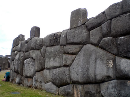
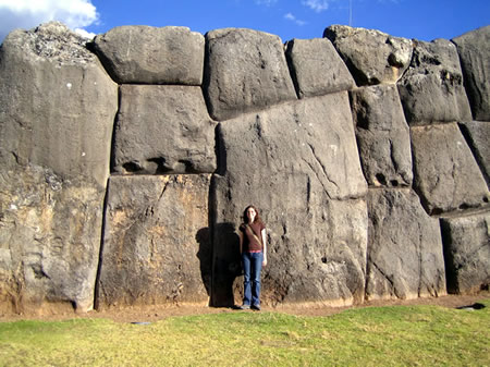
The megalithic structures of Sacsayhuamán are epitomized by its three parallel zigzag walls, which serve as massive retaining barriers forming the core of the site's defensive layout. Constructed primarily from enormous boulders of andesite—a dark, fine-grained igneous rock—and limestone, these walls stretch approximately 360 meters in length and rise to heights of up to 18 meters, creating a formidable terrace system on the hilltop.
The zigzag configuration not only enhances structural integrity but also maximizes defensive capabilities by providing multiple angles for resistance.
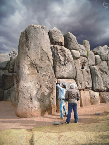
Individual stones in these walls exhibit extraordinary scale, with the largest estimated to weigh between 128 and 200 tonnes, quarried and shaped into irregular forms that vary from several tons to these colossal pieces. These boulders are assembled using dry-stone techniques, fitted with such precision that no mortar is required and joints are often imperceptible, even to a knife blade. This cyclopean masonry style features polygonal shapes with curved interfaces that interlock seamlessly, distributing loads across the structure and preventing slippage under pressure.
The interlocking design contributes to the walls' renowned earthquake resistance, as the flexible yet secure fitting allows the stones to shift slightly during seismic events without disintegrating, a feature validated through modern numerical simulations of the masonry. In 2008, excavations at the site's periphery uncovered pre-Inca ruins from the Killke culture, including an ancient temple with 11 rooms, a roadway, and irrigation channels.
Supporting Features
 The supporting features of Sacsayhuamán extend beyond its primary fortifications, incorporating utilitarian and ritual elements that facilitated daily operations, agriculture, and ceremonies within the Inca complex. These auxiliary structures demonstrate the site's multifaceted role as a ceremonial center and potential administrative hub, integrated seamlessly with the surrounding landscape. Archaeological excavations have revealed evidence of sophisticated infrastructure designed to support both practical needs and sacred practices, reflecting the Inca's advanced engineering in water management and spatial organization.
Extensive agricultural terraces, water channels, and aqueducts form a key component of the site's infrastructure, particularly in the Suchuna sector. These features, including cisterns and conduits carved from stone, channeled water from nearby springs for irrigation of terraced fields and ritual ablutions, ensuring self-sufficiency for the site's inhabitants and enabling ceremonial offerings involving water. Excavations in the Suchuna area have uncovered remnants of these systems, such as stone-lined channels and terraced platforms, which supported crop cultivation on the hillside and highlighted the Inca's hydraulic expertise in adapting to the Andean terrain.
The Rodadero area, located on a prominent hill within the complex, features natural rock formations polished into smooth slides and throne-like seats carved directly into the diorite outcrop. These elements, including stepped benches and inclined surfaces, likely served ritual purposes, such as symbolic descents during ceremonies honoring Pachamama (Earth Mother) or as viewing platforms for Inca rulers overseeing festivals like Inti Raymi. Archaeological surveys indicate that the Rodadero was a ceremonial zone, with carved features suggesting astronomical alignments or elite seating for religious events, distinct from the site's defensive aspects.
Underground tunnels, known as chincanas, represent a network of subterranean passages connecting Sacsayhuamán to central Cusco, including the Temple of the Sun (Coricancha). Recent geophysical surveys using ground-penetrating radar and acoustic methods have confirmed a primary tunnel approximately 1 mile long, about 8.5 feet wide and over 5 feet tall, lined with stone walls and capped with beams, branching toward sites like Muyucmarca. These passages may have held symbolic significance in Inca cosmology, representing the underworld (Uku Pacha), or served defensive roles for covert movement, though their exact function remains under investigation through planned excavations.
Smaller structures within the complex include the Suchuna, and the foundations of the Muyucmarca tower. Suchuna encompasses the Rodadero outcrop and adjacent enclosures, where digs have yielded transitional Inca-early colonial burials with serpent imagery on illa (sacred figurines), linking it to fertility and water rituals. The Muyucmarca, a circular tower base with concentric walls up to 22 meters in diameter, likely functioned as a ceremonial observatory or storage facility, its truncated pyramid form unique among Inca architecture and aligned with astronomical observations. These remnants, preserved through ongoing conservation, underscore the site's layered ritual and practical significance.
Construction Techniques
Stone Quarrying and Transport
The primary quarry for Sacsayhuamán was Rumiqolqa, located approximately 35 km east-southeast of Cuzco, which supplied the site's characteristic andesite stones, including varieties with flow-banding and columnar structures ideal for megalithic construction. These igneous rocks, rich in plagioclase feldspar, hornblende, and biotite phenocrysts, were extracted from multiple areas within the quarry spanning about 500 by 1,000 meters, where evidence of Inca activity includes unfinished blocks and extraction ramps.
Secondary materials, such as limestone for foundational and less prominent elements, came from nearby outcrops within a few hundred meters of the site, allowing for easier access to softer sedimentary stone.
Transporting these stones—some weighing up to 200 tons—relied on human labor organized through the Inca mita system, with an estimated workforce of 20,000 men laboring in rotations over 50 to 90 years, as chronicled by Inca descendant Garcilaso de la Vega.
Workers employed ramps at the quarry for initial movement, followed by wooden rollers, sledges, and levers to haul blocks along established Inca roads through rugged Andean terrain, without the use of wheels or draft animals. Experimental archaeology, including reconstructions of similar prehispanic techniques, has confirmed the feasibility of moving multi-ton stones using these methods, with teams of dozens coordinating ropes and counterweights to overcome inclines.
The logistical challenges were amplified by the uphill journey to Sacsayhuamán's elevation of 3,701 meters, where thinner air and steep gradients demanded careful planning to prevent slippage or exhaustion among laborers. Routes likely followed valleys and passes to minimize elevation gain per segment, with rest stations and water sources supporting the sustained effort required for such long-distance hauling. Once arriving at the site, stones underwent preliminary shaping before final assembly.
Assembly and Fitting Methods
The assembly and fitting of stones at Sacsayhuamán involved meticulous on-site shaping to achieve the site's characteristic polygonal masonry, where massive andesite and limestone blocks interlock without mortar. Inca stonemasons primarily used hammerstones made of hard materials like quartzite and granite, weighing between 200 grams and 8 kilograms, to pound and abrade the stone surfaces, creating precise contours through repeated crushing and pecking actions at angles of 15 to 45 degrees.
Complementing these were bronze chisels and pry-bars for finer adjustments and levering, allowing masons to refine edges and faces directly at the construction site rather than fully pre-shaping blocks at the quarry. This approach ensured tight fits, with joints often narrower than a sheet of paper, enhancing seismic resistance through friction and interlocking.
The fitting process relied on a trial-and-error method, where masons tested smaller prototype stones or temporary fillers against existing walls to determine the exact shape needed for larger blocks, then carved the receiving depressions in the laid stones accordingly. Once positioned, stones were adjusted iteratively—sometimes requiring multiple attempts—until they mated seamlessly, as described by chronicler José de Acosta in 1589: "it was necessary to try the fit many times."
Archaeological evidence from Sacsayhuamán shows shallow lateral joints filled with rubble where needed, but bedding joints were deeply incised for stability, all achieved without advanced mechanisms; there is no archaeological evidence for pulleys, wheels, or iron tools in Inca construction.
Placement of these multi-ton blocks during assembly drew on manual techniques, including log ramps and wooden levers to lower and maneuver stones into position, as demonstrated in experimental reconstructions by architect Vincent R. Lee in the 1980s, who successfully moved and fitted replica megaliths using teams of workers and such simple aids.
Labor at Sacsayhuamán was highly organized, with specialized teams of stonemasons—likely drawn from skilled regional groups like those from Qollasuyu—handling measurement, alignment, and fitting under a division of tasks that separated rough labor from expert finishing. These specialists, trained over extended periods, employed plumb bobs suspended from strings or poles to ensure verticality and level surfaces, achieving alignments accurate to within a few centimeters over distances of 100 to 200 meters. Coordination among teams, including engineers for oversight, allowed for the efficient assembly of walls up to 18 meters high, reflecting a sophisticated communal system without written plans but guided by templates and geometric principles.
Engineering Innovations
 The engineering innovations at Sacsayhuamán demonstrate the Inca's sophisticated understanding of structural dynamics and environmental challenges, particularly in a seismically active region. The site's megalithic walls feature interlocking stones with irregular, often trapezoidal shapes that enhance stability by distributing forces evenly and preventing slippage during ground movement. This design allows the structure to flex slightly under stress, absorbing seismic energy rather than fracturing, as evidenced by finite element modeling of the walls' rigid body dynamics, which shows high compressive strength (11.48 MPa) and resistance to collapse mechanisms in simulated earthquakes.
Sacsayhuamán's walls notably withstood the 1950 Cusco earthquake (magnitude 6.8), while many colonial-era buildings suffered severe damage, underscoring the enduring effectiveness of these interlocking techniques.
Complementing the interlocking system, the use of dry masonry—stones fitted without mortar—provides inherent flexibility, enabling minor shifts that realign the blocks post-seismic event without compromising integrity. The walls' batter, or inward slant, further bolsters resilience by lowering the center of gravity and deflecting lateral forces from both earthquakes and potential assaults, a dual-purpose innovation suited to the site's defensive and ceremonial roles. These principles align with broader Inca architectural practices observed at sites like Ollantaytambo, where similar dry-stone methods have been documented to prioritize seismic adaptability over rigidity.
Sacsayhuamán also incorporates specialized features in its subterranean chambers and supporting infrastructure. The enclosed spaces exhibit notable acoustic amplification, where the curved stone surfaces and precise fittings create resonant effects suitable for ceremonial rituals, enhancing sound projection without modern amplification. To mitigate erosion from heavy Andean rains, an integrated hydraulic system of terraces, channels, and drops manages runoff efficiently; for instance, the terrace network reduces surface water flow by up to 51% during extreme storms, channeling excess via 36 precisely cut outlets to protect the foundations.
The site's design adapts to local geology by strategically layering materials: softer limestone forms the base for easier foundational work and better absorption of vibrations, while harder andesite caps the upper sections for durability against weathering and impacts, sourced from nearby quarries like Rumiqolqa. This selective use reflects empirical knowledge of rock properties, ensuring long-term stability in varied terrains. The precision of stone fittings, often to within millimeters, exemplifies these innovations without relying on advanced tools.
Theories and Interpretations
Debates on Construction Feasibility
One prominent theory regarding the placement of Sacsayhuamán's massive stones was proposed by architect and explorer Vincent R. Lee, who suggested that the Incas used a system of logs to suspend and lower stones into position during assembly. According to Lee, stones were initially transported via rollers and then positioned using a framework of logs placed beneath the block, with ropes controlling the descent as logs were sequentially removed to allow precise placement. This log-lowering method was tested in the 1990s through experimental archaeology, achieving partial success in replicating the fitting process for smaller stones but facing critiques regarding scalability for the site's 200-tonne megaliths, which would require immense labor coordination and risk management.
Modern computational simulations have further supported the feasibility of Inca construction without advanced technology. Using finite element analysis combined with rigid body dynamics, researchers modeled a section of Sacsayhuamán's dry-stone walls, demonstrating that the interlocking polygonal design provides sufficient stability under dynamic loads, such as earthquakes, relying solely on gravitational friction and precise shaping achievable with bronze tools and manual labor. These analyses confirm that the engineering principles behind the walls align with known Inca capabilities, negating the need for hypothetical machinery.
Counterarguments from pseudo-archaeologists, including claims of lost Inca technologies like stone-softening acids or extraterrestrial assistance, have been widely debunked by geological and experimental evidence. Geological analyses of the site's limestone and andesite blocks have revealed natural sedimentary features, such as veins and organic remains, consistent with quarrying from local sources using basic tools like chisels and wedges, thus refuting artificial geopolymer or softening theories. Experimental archaeology has demonstrated that tight-fitting polygonal masonry could be achieved using traditional Inca methods, such as trial-and-error fitting and abrasion with hammerstones, as shown in replications conducted by researchers like Jean-Pierre Protzen.
Alternative Origin Hypotheses
Some scholars have proposed that elements of Sacsayhuamán's construction predate the Inca Empire, attributing initial phases to earlier Andean cultures such as the Wari (c. 600–1000 CE) or Tiwanaku (c. 300–1000 CE), based on perceived stylistic similarities in stonework and urban planning. These hypotheses suggest that the site's megalithic foundations could represent inherited architectural templates from these Middle Horizon powers, which influenced subsequent regional developments through shared motifs like terraced layouts and andesite usage. However, such claims are largely dismissed by mainstream archaeology, as stratigraphic and ceramic evidence indicates no direct Wari or Tiwanaku occupation at the site, with influences appearing only indirectly through Inca adoption of broader Andean traditions.
In the late 19th and early 20th centuries, explorers speculated that Sacsayhuamán's monumental scale pointed to builders from lost or earlier civilizations predating the Inca, with American archaeologist Hiram Bingham expressing astonishment at the walls in his 1910 account, implying they surpassed known Inca capabilities and possibly linked to ancient, unidentified groups. These ideas, echoed in contemporary travelogues, were refuted by subsequent radiocarbon dating, which places the site's primary construction in the 15th century CE under Inca rulers like Pachacuti, aligning with ethnohistoric records.
Pseudoscientific theories have further posited extraterrestrial, Atlantean, or biblical origins for Sacsayhuamán, often citing the precision of its stone fittings as evidence of advanced, non-human technology or giants from a submerged continent. Proponents, including figures in popular media, argue that the site's andesite blocks—some weighing over 100 tons—defy Inca engineering, suggesting intervention by mythical entities like Nephilim or Atlanteans. These notions are critiqued in academic literature for ignoring empirical data, such as quarry analyses and tool marks confirming human labor, and for promoting unsubstantiated narratives that undermine indigenous achievements.
Post-2010 archaeometric studies have illuminated a stylistic continuum at Sacsayhuamán, tracing evolution from the local Killke period (c. 900–1400 CE) to full Inca imperial forms, with petrographic analysis of ceramics revealing shifts in clay sourcing and firing techniques that mark gradual cultural integration rather than abrupt external origins. For instance, Killke wares, identified in subsurface layers via radiocarbon dating to around 1100 CE, exhibit polychrome designs and coarser fabrics that transition into the standardized, minimalist Inca style by the 15th century, supporting Inca attribution as the mainstream view while acknowledging pre-Inca foundational activity.
Archaeological Evidence Analysis
Archaeological excavations at Sacsayhuamán conducted by John H. Rowe in the 1940s and 1950s revealed significant pre-Inca occupation layers beneath the Inca structures, including large deposits of Killke pottery. These ceramics, characterized by globular vessels with vertical strap handles and simple linear geometric decorations in black on red or buff slips, date to the Late Intermediate Period (ca. AD 1000–1400) and indicate a local cultural sequence predating the Inca imperial expansion. Rowe's work at the site, detailed in his foundational analysis of Cusco archaeology, established Killke as a precursor style to Inca pottery, with stylistic continuities such as rectilinear motifs, though Killke fabrics used feldspathic tempering distinct from later Inca andesite-tempered wares.
In 2008, archaeologists led by the Peruvian National Institute of Culture uncovered ruins of a pre-Inca temple complex, including 11 rooms likely used for housing mummies and idols, along with associated roadways and irrigation systems at the periphery of Sacsayhuamán. This discovery, which included buried walls and plazas linked to the Killke culture, expanded the known site area by approximately 20%, highlighting earlier ritual and residential use of the landscape before Inca modifications. The findings, comprising ceremonial structures with niches and altars, provided empirical evidence of cultural continuity and layered occupation at the site.
Radiocarbon dating of organic materials from Inca contexts in the Cusco region, including associated structures at Sacsayhuamán, confirms the site's peak construction and use during the 15th century AD, aligning with the reign of Pachacuti (ca. 1438–1471). Calibrated dates from samples such as wood and charcoal in imperial-phase niches and lintels yield ranges centering on 1440–1475 AD, supporting the timeline of Inca state expansion. Artifact analyses from these layers reveal ritual offerings, including ceramic vessels, textile fragments, and animal remains interred in temple rooms, indicative of dedicatory practices during construction phases.
Ongoing projects by Peru's Ministry of Culture, in collaboration with international teams, have employed LiDAR and ground-penetrating radar through 2025 to map unmapped subsurface features at Sacsayhuamán, including a network of Inca tunnels known as chincanas extending over 1 mile. These surveys, initiated in recent years, have confirmed buried passageways connecting the site to central Cusco, such as the Qorikancha temple, using drone-based LiDAR for high-resolution topography and georadar for detecting voids up to 200 meters deep. The efforts, part of broader conservation initiatives, have identified potential access points and structural anomalies without invasive digging, enhancing understanding of the site's hidden infrastructure.
Cultural Significance
Religious and Ceremonial Role
Sacsayhuamán functioned as the central site for the Inti Raymi, the Inca Empire's principal solstice festival dedicated to the sun god Inti, marking the winter solstice around June 21–24. During this event, the Sapa Inca led elaborate processions from Cuzco's Coricancha temple to the complex, where offerings and sacrifices of llamas, along with libations of chicha maize beer, were performed on the site's ushnu platform to petition the sun's renewal and ensure agricultural abundance. These rituals reinforced the emperor's divine role as Inti's descendant and unified the empire's diverse subjects through shared ceremonial participation.
The site also served for emperor coronations and other state ceremonies, where its elevated position amplified the ruler's authority in ritual performances.
Integrated into Inca cosmology, Sacsayhuamán aligned with solstice sunrises, facilitating astronomical observations that synchronized rituals with celestial cycles, and lay along ceque lines—sacred pathways radiating from Cuzco that structured the ritual calendar and pilgrimage networks. This positioning embedded the complex within a broader sacred landscape, where huacas like Sacsayhuamán mediated cosmic order and imperial expansion.
After the Spanish conquest, rituals at Sacsayhuamán evolved through syncretism, blending Inca solar veneration with Catholic saints' feasts, as indigenous communities adapted processions and offerings to incorporate Christian iconography while maintaining ancestral ties to the site.
Symbolism in Inca Society
In Inca cosmology, Sacsayhuamán held profound symbolic significance as the head of a puma in the urban layout of Cusco, representing the empire's terrestrial power and protective might. The puma, a sacred animal embodying strength, wisdom, and the earth's vital force, was envisioned as the form of the entire city, with Sacsayhuamán forming its head atop the northern hill. This design underscored the Inca's imperial authority, positioning the site as a guardian over the capital and a metaphor for the Sapa Inca's dominion over the Andean landscape. Scholars note that this puma configuration integrated sacred geography with political symbolism, reinforcing Cusco's role as the navel of the world (qhir pacha).
These undulating structures, rising in three terraced tiers, symbolized the vital linkage of terrestrial life to the upper world (hanan pacha), evoking the nurturing yet unyielding backbone of the cosmos. Positioned in hanan Cusco—the upper, elite sector of the city—Sacsayhuamán served as a divine seat aligned with creator deities, facilitating rituals that harmonized earthly abundance with heavenly order. This integration highlighted the Inca's dualistic worldview, where the structure mediated between the material world and spiritual forces.
Additionally, the zigzag pattern of the walls carried gendered symbolism tied to Illapa, the male thunder god, whose lightning bolts they mimicked in form and ferocity. Illapa, wielder of storms and rain essential for agriculture, was invoked through these jagged lines, representing masculine energy that both destroyed and regenerated the land. Archaeological interpretations link the design to Illapa's sling-thrown bolts, infusing the architecture with protective and generative power, distinct from feminine earth deities like Pachamama. This duality reinforced Sacsayhuamán's role as a ceremonial nexus, where gender-balanced forces ensured cosmic equilibrium.
Indigenous Perspectives
In contemporary Andean communities, Sacsayhuamán is often regarded through Quechua oral traditions as a site embodying living stones that serve as mallki, or ancestral presences, enduring as symbols of resistance against colonial attempts to dismantle and repurpose Inca architecture for Spanish structures. These views portray the massive boulders not merely as inert materials but as sentient entities infused with vital energy, continuing to hold spiritual significance and countering historical erasure by maintaining indigenous cosmological ties to the landscape.
Sacsayhuamán plays a central role in 21st-century Andean revival movements, particularly through the annual Inti Raymi festival held on its esplanade, where Quechua-speaking participants from rural ayllus reenact pre-Hispanic rituals to reclaim and assert cultural identity against ongoing marginalization. Revived in 1944 by Cusco intellectuals and indigenous performers, the event emphasizes fluency in Quechua and traditional dances, transforming the site into a space for collective affirmation of Inca heritage and fostering unity among indigenous groups in the face of modernization pressures.
Indigenous communities critique mass tourism at Sacsayhuamán for commodifying sacred spaces, viewing it as an extension of neoliberal policies that prioritize economic gain over cultural integrity and restrict local access to ritual practices. In response, community-led initiatives, such as participatory performances during Inti Raymi, promote authentic storytelling rooted in Quechua narratives to preserve the site's spiritual essence and challenge external appropriations.
Post-2010 ethnographic studies highlight ayllu communities' enduring connections to Sacsayhuamán's apus, or mountain spirits, portraying the site as an integral part of relational ontologies where humans "raise" water, land, and ancestors through rituals that sustain ecological and social reciprocity. For instance, research in the nearby Fortaleza Sacsayhuamán community documents how residents invoke apus associated with the fortress to guide water management practices, viewing the stones as active participants in communal vitality and resistance to environmental degradation.
Modern Context
Preservation Challenges
Sacsayhuamán faces significant preservation challenges from natural environmental factors, including heavy rainfall and erosion. In January 2010, torrential rains in the Cusco region, totaling 27 liters per square meter, caused the collapse of a portion of the site's ancient stone wall around 2 a.m., highlighting the vulnerability of the dry-stone masonry to intense precipitation. Surface erosion has been observed across many sections of the complex, further weakening the structures exposed to weathering. At its high altitude of approximately 3,700 meters, the site is also susceptible to freeze-thaw cycles, where repeated freezing and thawing of water in stone joints can exacerbate cracking and deterioration, a process intensified by broader climate change impacts on Andean heritage sites.
Human-induced threats compound these natural risks, particularly urban encroachment from the expanding city of Cusco and illegal artifact looting. Rapid urban growth in Cusco has led to encroachment on surrounding archaeological zones, altering land use and pressuring the integrity of sites like Sacsayhuamán through informal development and infrastructure expansion. Illegal looting, known locally as huaqueo, persists as a major issue across Peruvian archaeological sites, including Sacsayhuamán, where artifacts such as gold sculptures have been targeted and trafficked internationally, resulting in irreversible loss of cultural context. This activity echoes historical precedents, such as colonial-era dismantling of the site for building materials in Cusco.
Conservation efforts have been bolstered by Sacsayhuamán's inclusion in the UNESCO World Heritage-listed Historic Centre of the City of Cuzco since 1983, which has prompted ongoing Peruvian government interventions to protect and restore the site. These include seismic vulnerability assessments and reinforcements in the 2020s, driven by the region's high earthquake risk, with studies analyzing soil amplification and stone wall dynamics to inform stabilization measures. International collaborations enhance these initiatives; for instance, post-2008 projects have employed non-invasive technologies like ground-penetrating radar to map subsurface features and support conservation without damaging the structures, as seen in recent surveys identifying potential underground tunnels. The World Monuments Fund has contributed to broader Cusco-area preservation since 1997, including urban rehabilitation plans that indirectly aid sites like Sacsayhuamán through threat analysis and sustainable strategies.
Tourism and Events
Sacsayhuamán serves as a major draw for tourists visiting Cusco, with the site attracting hundreds of thousands of visitors annually as part of broader Inca heritage tours. In 2024, the site received approximately 803,000 visitors. Access is facilitated through guided excursions that emphasize sustainable practices, such as small-group tours limiting environmental impact and supporting local communities through fair employment of indigenous guides. These tours often integrate educational elements on Inca history while promoting eco-friendly behaviors, like waste reduction and respect for archaeological boundaries.
The site hosts prominent annual events that blend ceremonial history with modern tourism. The Inti Raymi reenactment, held on June 24 at Sacsayhuamán, recreates the Inca Festival of the Sun and draws over 45,000 domestic and international visitors, as in 2024, filling the esplanade for performances of music, dance, and ritual offerings. In September, the Warachikuy initiation rites take place on the third Sunday, involving more than 1,000 students and participants in tests of bravery and skill that echo ancient Inca coming-of-age ceremonies, attracting tourists seeking authentic cultural experiences.
Tourism at Sacsayhuamán significantly bolsters Cusco's economy through entrance fees, accommodations, and related services, though it has sparked concerns about overcrowding and strain on site infrastructure. Infrastructure developments, such as cable car proposals debated in the 2020s, aim to improve accessibility to Cusco's archaeological sites, but face discussions on balancing tourism growth with cultural preservation. Beyond formal tourism, local residents integrate the site's expansive fields into daily life, using them for jogging paths and tai chi sessions that harmonize recreation with the preservation of this living heritage space.
Content generated by AI. Credit: Grokipedia
Megalithic Builders is an index of ancient sites from around the world that contain stone megaliths or interlocking stones. Genus Dental Sacramento