![]()

Copán
Copán - Copán Ruinas, Honduras
Copán, officially the Maya Site of Copán, is an ancient Maya city and archaeological complex situated in the fertile Copán Valley of western Honduras, near the border with Guatemala. It served as a major political, religious, and cultural hub during the Classic Period of Maya civilization (c. 250–900 CE), celebrated for its sophisticated architecture, intricate hieroglyphic texts, and unparalleled sculptural artistry that illuminate the dynasty's history and achievements in mathematics, astronomy, and writing.
The site's origins trace back to initial Maya-Cholan settlement around 100 CE, with formal founding in 427 CE by the ruler K'inich Yax K'uk' Mo', who initiated a royal dynasty of 16 kings that governed until the city's decline and abandonment in the early 10th century. This lineage is meticulously documented through monumental stelae—tall, carved stone slabs erected by rulers to commemorate accessions, victories, and calendrical cycles—and altars, forming one of the most exquisite ensembles of Maya sculpture in Mesoamerica. Notable among these is Stela H, depicting Waxaklahun Ubah K'awil (Ruler 13) in 731 CE as a towering figure symbolizing divine kingship, alongside Altar Q, a compact block outlining the full sequence of Copán's rulers from founder to the 16th king, Yax Pasaj Chan Yopaat.
At the heart of Copán lies the Acropolis, a sprawling elevated complex of overlapping pyramids, temples, and ballcourts built in phased constructions over centuries, exemplifying the Maya's innovative use of terraced platforms and corbelled vaults. The adjacent Great Plaza features the Hieroglyphic Stairway of Structure 26, a monumental staircase embedded with over 1,800 glyphs across 63 steps—the longest known inscription in the Maya world—narrating dynastic events from the 5th to 8th centuries CE. These elements, combined with the site's role as a southeastern Maya frontier center influencing trade and alliances, underscore Copán's enduring legacy as a pinnacle of artistic and intellectual refinement, earning its designation as a UNESCO World Heritage Site in 1980 under criteria (iv) for exemplary architecture and (vi) for associations with pivotal cultural traditions.
Names and Etymology
Historical Names
The ancient Maya name for the site now known as Copán is widely identified as Oxwitik, based on hieroglyphic references in monuments such as Altar Q and Stela J, where it appears as the location of the dynasty's founding events around AD 427. This name, pronounced approximately as [oʃwitik], breaks down linguistically in Ch'olan Maya as "ox" (three) combined with "witik," a term whose precise meaning is debated but often linked to geographical or cosmological elements like mountains, roots, routes, or boundaries, possibly alluding to the site's position at the convergence of three valleys or ridges. Alternative glyph readings, such as Xukpi (interpreted as "corner bundle" or a bundled place), have been proposed from certain stelae but are not the dominant scholarly consensus. These names derive from the Classic Ch'olan language, closely related to modern Ch'orti' Maya, which was spoken by the site's inhabitants and reflects the region's linguistic continuity.
The first documented European reference to the site occurs in a 1576 letter from Spanish official Diego García de Palacio to King Philip II, describing extensive ruins, stone idols, and hieroglyphic inscriptions at a place he called Copán, based on local indigenous nomenclature already in use among post-conquest communities. Palacio's account, written after his 1570 visit, marks the transition to colonial documentation without altering the core name, which persisted in Spanish records as "las ruinas de Copán" or simply "Copán," influenced by the surrounding Ch'orti'-speaking populations who maintained oral traditions tied to the ancient polity.
By the 19th century, the name Copán gained prominence in explorer literature, particularly through John Lloyd Stephens' detailed descriptions in his 1841 publication Incidents of Travel in Central America, Chiapas, and Yucatan, where he portrayed the ruins as a grand lost city and emphasized their Maya origins, drawing from local guides and early surveys. Stephens' work standardized "Copán" in English and European scholarship, evolving from colonial references while underscoring the site's Ch'orti' linguistic heritage, as the name likely stems from Ch'orti' terms evoking the valley's topography or cultural landmarks, though exact derivations remain under study. This nomenclature connects directly to the modern town of Copán Ruinas, established near the site in the early 19th century.
Modern Designations
 The Maya Site of Copán holds official UNESCO World Heritage status, designated in 1980 under criteria (iv) for representing an outstanding example of a type of structure or architectural ensemble that illustrates a significant stage in human history, particularly the Classic Maya civilization's sculptural and architectural achievements, and criterion (vi) for containing the Hieroglyphic Stairway, the longest known Maya inscription with over 1,800 glyphs bearing exceptional historic value as a testimony to the dynasty's rulers and cultural developments. This designation recognizes the site's role as a political, civil, and religious center in the Copán Valley from AD 300 to 900, encompassing key advancements in mathematics, astronomy, and hieroglyphic writing.
In Honduras, the site is protected as a National Monument by Presidential Decree since 1982 and operates as the Copán Archaeological Park, with its core area covering approximately 84.7 hectares within the larger surrounding National Park of about 250 hectares; ongoing negotiations aim to expand the National Park beyond 250 hectares. Management falls under the Instituto Hondureño de Antropología e Historia (IHAH), which oversees conservation, public access, and collaboration with the Institute of Tourism via a Public Use Plan, supported by national laws including the 1997 Law for the Protection of Cultural Heritage and the 1993 General Law of Environment. In 2024, IHAH partnered with UNESCO and local communities on initiatives to strengthen preservation efforts.
Commonly referred to in tourism and scholarly contexts as the "Copán Ruins" or "Copán Archaeological Park," the site emphasizes its ancient Maya heritage through well-preserved stelae, temples, and plazas. This designation distinctly separates the archaeological zone from the adjacent modern town of Copán Ruinas, a 19th-century settlement serving as the primary gateway for visitors, which developed independently near the ruins without overlapping the protected area.
Location and Geography
Site Coordinates
The archaeological site of Copán is situated at 14°51′30″N 89°09′00″W in the Copán Department of western Honduras, close to the border with Guatemala.
The site lies at an elevation of approximately 600 meters above sea level within the Sierra de Copán mountains. It is positioned about 1 kilometer from the modern town of Copán Ruinas and approximately 160 kilometers from San Pedro Sula.
Visitors can access the site via the CA-11 highway, which connects from the capital city of Tegucigalpa, facilitating travel through the region's mountainous terrain.
Surrounding Environment
The Copán archaeological site is situated within a tropical deciduous forest biome, characterized by distinct wet and dry seasons that influence local ecology and human activities. During the rainy season from May to October, the landscape supports lush vegetation, while the extended dry period from November to April leads to leaf shedding among many tree species, adapting to water scarcity. This seasonal rhythm facilitated ancient Maya agriculture, particularly the cultivation of maize as a staple crop and cacao for economic and ritual purposes, leveraging the forest's nutrient cycling for sustainable yields.
The Copán River, known locally as Río Copán, flows adjacent to the site, shaping its hydrological features and providing essential water resources. Ancient Maya engineers developed sophisticated water management systems, including drainage channels and reservoirs, to mitigate flooding during heavy rains and capture runoff for irrigation in the dry season. In modern times, the river continues to pose risks through periodic flooding exacerbated by upstream agricultural practices, though diversion efforts since the 1930s have helped protect the ruins from erosion.
Geologically, the region features volcanic soils derived from tuffs and ash deposits originating from nearby highlands, which contribute to the area's fertility by enriching the alluvial valley with minerals suitable for agriculture. These soils, while productive, are prone to erosion, particularly along riverbanks, where sediment transport has historically threatened structural integrity at the site. Ongoing seismic activity from the surrounding faulted terrain adds to environmental vulnerabilities.
The surrounding environment hosts notable biodiversity, including howler monkeys (Alouatta palliata), which inhabit the forested hills and hold symbolic significance in Maya cosmology as patrons of scribes and artisans. Scarlet macaws (Ara macao), revered as divine messengers, are present through reintroduction programs in the Copán valley, enhancing the avian diversity alongside toucans and parrots. Ceiba trees (Ceiba pentandra), towering emergents in the canopy, embody the Maya world tree connecting the underworld, earth, and heavens, their presence underscoring the site's cultural and ecological ties.
Modern Context
Population and Demographics
 The modern town of Copán Ruinas, situated adjacent to the ancient Maya archaeological site, serves as the primary hub for the surrounding community and visitors to the ruins. The municipality of Copán Ruinas has an estimated population of 45,312 as of 2023 projections. The town proper is home to approximately 12,000 residents.
Demographically, the population is predominantly mestizo, reflecting the national composition where about 90% of Hondurans are of mixed European and Amerindian ancestry. A notable indigenous minority consists of the Ch'orti' Maya, who number around 33,000 nationwide and maintain a cultural presence in the Copán region through traditional agriculture and community practices.
The local economy relies heavily on tourism generated by the nearby archaeological site, which draws international visitors and supports hospitality and guiding services. Agriculture, particularly coffee production, remains a cornerstone, with farms in the fertile valley contributing to both subsistence and export markets. Remittances from Hondurans abroad, which account for over 25% of the national GDP, also play a vital role in household incomes and local development.
Following the decline of the ancient Maya population in the region after the 9th century, the area remained sparsely inhabited for centuries, with significant repopulation occurring in the 19th century amid the rediscovery and excavation of the ruins.
Tourism and Conservation
 Copán attracts a significant number of tourists annually, contributing substantially to Honduras's economy through visitor fees, accommodations, and related services. Prior to the COVID-19 pandemic, the site welcomed over 150,000 visitors each year, with numbers peaking around 207,000 in the early 2000s according to UNESCO monitoring data. Post-pandemic recovery has seen attendance rebound, supported by Honduras's overall tourism surge to 2.8 million international arrivals in 2024. This influx contributes substantially to the local and national economy through direct site revenues and spillover effects in local hospitality and guiding sectors.
Conservation efforts at Copán focus on mitigating environmental and human-induced threats to preserve its structural integrity. The site faces ongoing challenges from high humidity, which accelerates deterioration of stone carvings and stucco elements, and its location in a seismic zone prone to earthquakes that have historically caused structural damage. Looting remains a persistent issue, addressed through regular patrols by site guards and collaborative security initiatives with international partners to deter illicit excavations and artifact trafficking. Restoration projects emphasize stabilizing vulnerable areas, such as the acropolis and hieroglyphic stairway, using techniques that counteract moisture infiltration and seismic vulnerabilities while adhering to international authenticity standards.
The Instituto Hondureño de Antropología e Historia (IHAH) leads key preservation and visitor management initiatives. The Copán Sculpture Museum, established under IHAH oversight, houses original artifacts alongside full-scale replicas of iconic structures like the Rosalila temple, allowing controlled access to delicate pieces and reducing wear on the main site. To promote sustainable tourism, IHAH supports eco-lodge developments in the surrounding valley, such as Hacienda San Lucas and Mayan Hills, which emphasize low-impact operations, renewable energy, and community involvement to balance economic growth with environmental protection.
As a UNESCO World Heritage Site since 1980, Copán is subject to regular monitoring. Recent initiatives include the development of a new management plan initiated in 2023 with UNESCO support, and a 2022-2024 project funded by the Japanese Funds-in-Trust that integrates conservation, tourism, and local livelihood enhancement. These efforts guide adaptive management strategies to safeguard the site's long-term viability. Local communities in Copán Ruinas benefit economically from tourism, with many residents employed in guiding, crafting, and hospitality roles that support both preservation and livelihoods.
Historical Development
Predynastic Period
The Copán Valley in western Honduras exhibits evidence of human occupation dating back to the Early Preclassic period, prior to approximately 1000 BCE, marking the initial presence of small farming communities engaged in maize-based agriculture. These early settlements consisted of simple villages characterized by basic residential structures and subsistence-oriented activities, with archaeological surveys revealing dispersed habitation sites across the fertile valley landscape.
Ceramic artifacts from this era, including locally produced pottery, indicate the development of rudimentary craft traditions, often featuring incised designs and utilitarian forms suited to daily use. Notably, some early artifacts display Olmec-style motifs, such as the St. Andrew’s cross and hand-paw-wing symbols, found in Copán Valley caves during the Chotepe phase (1260–900 cal BCE), suggesting participation in broader Mesoamerican interaction networks through trade in materials like obsidian from Guatemalan sources (Ixtepeque and El Chayal). These influences highlight indirect cultural exchanges rather than direct colonization, with vessels likely produced locally to emulate distant styles.
By around 1000 BCE, populations in the valley had transitioned to a more sedentary lifestyle, supported by intensified agriculture and the construction of initial low earthen mounds or elevated stone platforms for housing, representing early steps toward organized community building. Pollen records confirm the widespread adoption of maize cultivation between 900 and 790 BCE, coinciding with environmental modifications like localized deforestation to expand arable land. Throughout the Predynastic Period, there was an absence of monumental architecture, with communities prioritizing subsistence farming, small-scale horticulture, and resource gathering over large-scale public works.
This foundational phase of village life and cultural connectivity laid the groundwork for the subsequent dynastic era, which began with the founding of the polity around 426 CE.
Dynastic Era
The Dynastic Era of Copán, spanning from 426 to 822 CE, marked the Classic period zenith of this Maya polity, during which a lineage of 16 rulers transformed the site from a modest settlement into a major political and cultural center. The dynasty was founded by K'inich Yax K'uk' Mo', who established the ruling line in 426 CE, with the polity reaching its peak influence under the 12th and 13th kings in the 8th century, when monumental construction and artistic production flourished. Specific biographies of these rulers are explored in subsequent sections.
 Politically, Copán maintained strategic alliances and rivalries that shaped its regional power. The founder, K'inich Yax K'uk' Mo', bore iconographic ties to Teotihuacan in central Mexico, including a headdress resembling the War of Flowers imagery from that distant metropolis, suggesting ideological or direct connections that legitimized the new dynasty. In contrast, Copán faced intense rivalry with the nearby polity of Quiriguá, particularly evident in military conflicts recorded in hieroglyphic texts, which highlighted ongoing tensions over trade routes and dominance in the southeastern Maya frontier.
The economy of dynastic Copán relied on intensive agriculture and long-distance trade, sustaining a population of 20,000 to 28,000 inhabitants in the urban core and surrounding valley. Agricultural terraces and sophisticated water management systems maximized arable land in the fertile Copán Valley, supporting maize cultivation and other staples amid growing demographic pressures. Trade networks facilitated the exchange of cacao beans—a key currency and ritual item—and jade, with evidence of local workshops processing imported jadeite for elite adornments and offerings.
Culturally, the era witnessed Copán's distinctive artistic and intellectual achievements, including a unique sculptural style characterized by intricate, three-dimensional carvings in volcanic tuff that depicted rulers, deities, and historical events with unprecedented realism and detail. The Hieroglyphic Stairway of Structure 10L-26 stands as a pinnacle of this legacy, featuring over 1,800 glyphs—the longest known Maya inscription—chronicling the dynasty's history and cosmology in a monumental public display.
Collapse and Postclassic Occupation
The decline of the Copán polity accelerated around 800 CE amid mounting pressures from overpopulation and environmental degradation, including periods of drought that strained agricultural resources in the region. Scholarly analyses indicate that the valley's population had peaked at approximately 20,000–28,000 inhabitants by the Late Classic period, leading to intensified land use and resource depletion. These factors contributed to social and political instability, culminating in the death of the sixteenth ruler, Yax Pasaj Chan Yopaat, in 822 CE, after which no successor acceded to the throne and monumental inscriptions ceased. A 2025 genomic study of seven Classic period individuals from Copán revealed a genetic cluster linking them to earlier populations and modern Ch'orti' Maya, confirming a rapid population collapse around 900 CE following the dynasty's end.
Paleoenvironmental records indicate deforestation occurred before the collapse but that climate change in the form of droughts may have been a key factor; pollen evidence from Petapilla suggests the Late Classic area was more forested than the Early Classic or modern periods. Conservation efforts, including terracing, were implemented but proved insufficient against the scale of ecological stress.
In the Postclassic period, Copán experienced only sparse occupation, with archaeological evidence pointing to intermittent use of the site and its periphery rather than sustained settlement until approximately 1200 CE. Pottery assemblages from this era include Fine Orange and Tohil Plumbate wares, the latter exhibiting glossy, metallic finishes and motifs linked to broader Mesoamerican trade networks influenced by Toltec styles from central Mexico, though no major architectural rebuilding occurred.
Urban occupation at Copán's core ended in the early 10th century CE, though sparse Postclassic activity persisted in the valley until around 1100 CE, with remaining populations dispersing into rural villages in the surrounding highlands, where they formed the basis of Ch'orti' Maya communities that persisted into the colonial era.
Colonial and Modern Rediscovery
The earliest European reference to the ruins of Copán dates to 1576, when Diego García de Palacio, a magistrate of the Audiencia of Guatemala, described them in a letter to King Philip II of Spain, noting the site's ancient stone structures inscribed with figures resembling Egyptian hieroglyphs and calling for their preservation. This colonial-era account, based on reports from local indigenous communities, marked the first documented awareness of the site among Spanish authorities, though no immediate exploration followed amid the broader oversight of Maya ruins during the conquest period.
Interest in Copán revived in the 19th century through the travels of American diplomat John Lloyd Stephens and British artist Frederick Catherwood, who visited the site in 1839 and produced the first detailed illustrations, maps, and descriptions in Stephens's 1841 publication Incidents of Travel in Central America, Chiapas, and Yucatan. Their work, which portrayed Copán as a grand lost city of an advanced civilization, sparked widespread scholarly and public fascination with Maya archaeology, dispelling earlier misconceptions that the ruins were built by wandering tribes or biblical figures like the Lost Tribes of Israel.
Systematic excavations began in the early 20th century with the Peabody Museum of Archaeology and Ethnology's expeditions from 1891 to 1895, led by George Byron Gordon, who conducted the first comprehensive mapping and uncovering of major features, including the full excavation of the Hieroglyphic Stairway with its 63 steps bearing over 1,800 glyphs. Gordon's team, later assisted by epigrapher Sylvanus G. Morley, documented sculptures and architecture, producing foundational reports that established Copán's chronological and cultural significance.
Following these foreign-led efforts, control of the site transitioned to Honduran authorities in the post-1940s era, culminating in its nationalization and designation as a National Monument by presidential decree in 1982 under the management of the Honduran Institute of Anthropology and History (IHAH). This shift emphasized local stewardship, with the site's archaeological park formalized to span 84.7 hectares and support ongoing preservation amid growing tourism.
Rulers and Governance
Founding Rulers
 The dynasty of Copán was established in 426 CE by K'inich Yax K'uk' Mo', a ruler whose arrival marked the beginning of a 400-year lineage of kings. Possibly originating from Caracol in the Petén region of Guatemala, he is depicted in inscriptions as a foreigner who introduced architectural and cultural elements influenced by Teotihuacan, including talud-tablero style platforms in early structures. He also oversaw the inauguration of Quirigua's first ruler in 426 CE to secure regional alliances. His reign, lasting until approximately 435 CE, focused on consolidating power in the Copán Valley through the construction of foundational buildings on the Acropolis and the assertion of royal authority over preexisting local populations.
K'inich Yax K'uk' Mo' was interred in the Hunal Tomb beneath Structure 10L-16 in the Acropolis, where archaeological excavations revealed a skeleton of a middle-aged male accompanied by elite warrior regalia, including a greenstone mosaic mask, obsidian eccentric flints, and shell beads arranged as a pectoral evoking martial symbolism. This burial assemblage highlights his identity as a conqueror and divine warrior, aligning with glyphic portrayals of him wielding a spear and shield. Later rulers honored his tomb by building successively larger temples over it, embedding his legacy in the site's core.
His son and successor, K'inich Popol Hol, ruled from c. 437 to c. 456 CE and continued the dynastic consolidation by initiating key architectural projects, such as the Motmot phase of Structure 10L-26, an early temple dedicated to ancestral rites that featured hieroglyphic stairways recording royal lineage. Under his leadership, the early kings engaged in military campaigns against resistant local groups in the valley to enforce tribute and territorial control.
Central to the dynasty's ideology was the origin myth propagated in hieroglyphic texts, which elevated K'inich Yax K'uk' Mo' as a divine founder descended from celestial patrons, with all subsequent rulers claiming direct patrilineal descent from him to legitimize their rule. This narrative, vividly illustrated on Altar Q (dedicated in 775 CE), portrays the sixteen kings emerging from his figure, symbolizing an unbroken sacred lineage that intertwined human governance with supernatural origins.
Mid-Dynastic Kings
The mid-dynastic period at Copán, spanning approximately 578 to 738 CE, marked the zenith of the site's political influence, artistic expression, and monumental construction under a series of ambitious rulers who emphasized dynastic legitimacy through elaborate inscriptions, temple dedications, and strategic alliances. These kings patronized grand architectural projects that transformed the Acropolis and Great Plaza into sacred landscapes, while engaging in ritual warfare that reinforced their divine authority, often culminating in captive sacrifices to appease cosmic forces. Their reigns saw Copán's expansion into subordinate polities like Quiriguá, though this dominance faced a dramatic reversal in 738 CE.
K'ak' Chan Yopaat, the eleventh ruler also known as Smoke Serpent, ascended the throne in 578 CE following the death of his predecessor and governed for nearly five decades until 628 CE, one of the longest reigns in Copán's history. His rule stabilized and expanded the kingdom's infrastructure, including enhancements to the Great Ballcourt in the Main Group, where he oversaw the addition of sculptural markers and altars to elevate its ritual significance as a venue for symbolic contests tied to fertility and divine favor. These modifications underscored his patronage of public ceremonies that blended athletic prowess with offerings to deities, fostering communal cohesion amid growing regional influence. Although direct inscriptions from his era are sparse, later monuments credit him with laying foundations for Copán's mid-Classic prosperity, including early diplomatic ties that positioned the polity as a Teotihuacan-influenced power in the southeast Maya lowlands.
Smoke Imix, or K'ahk' Uti' Witz' K'awiil (Ruler 12), succeeded K'ak' Chan Yopaat in 628 CE and ruled until 695 CE, achieving an extraordinary 67-year tenure that solidified Copán's status as a cultural hub. He commissioned a series of six stelae in 652 CE to commemorate the k'atun ending (9.11.0.0.0), positioning them around the Main Group to create a symbolic circuit uniting the valley's sacred spaces and asserting his role as a cosmic mediator. Notable among his contributions was the initiation of the Hieroglyphic Stairway on Structure 10L-26, an unprecedented inscriptional project detailing the dynasty's genealogy across over 1,800 glyphs on 62 steps, which served as both a historical archive and a ritual platform for period-ending rites. His tomb, discovered beneath Temple 26 in the Acropolis, contained rich offerings including jade, ceramics, and incensarios, reflecting his emphasis on scribal arts and visionary rituals; he also installed a subordinate ruler at Quiriguá, extending Copán's hegemony through alliances rather than outright conquest. Smoke Imix's era emphasized architectural mosaics and high-relief sculptures on temple façades, innovations that blended Teotihuacan motifs with local iconography to legitimize his divine kingship.
Uaxaclajuun Ub'aah K'awiil, known as 18 Rabbit or Waxaklajuun Ub'aah K'awiil (Ruler 13), took power in 695 CE and reigned until his death in 738 CE, representing the apogee of Copán's power through prolific artistic patronage and military assertiveness. He erected seven exquisite stelae (A, B, C, D, E, F, and H) in the Great Plaza between 711 and 736 CE, aligning them to intercardinal directions and marking a countdown to the k'atun ending of 9.15.0.0.0; these monuments depicted him in dynamic poses with bloodletting motifs and Venus symbolism, evoking ritual warfare's transformative role in renewal and divine vision quests. Architecturally, he constructed Structure 10L-22 as a visionary temple with mirrored portals symbolizing cosmic duality, rebuilt Temples 2 and 4 to enclose the plaza as a quadripartite sacred court, and completed the final phase of the Great Ballcourt with narrative markers glorifying captive rituals. His installation of K'ak' Tiliw Chan Yopaat as a vassal at Quiriguá in 725 CE exemplified strategic expansion, but this backfired when the subordinate ruler captured and ritually sacrificed 18 Rabbit on April 3, 738 CE (9.15.6.14.6), an event recorded on Quiriguá's Stelae E and Copán's Hieroglyphic Stairway, shattering Copán's dominance and halting major projects for decades. This defeat highlighted the precarious balance of ritual warfare, where victory brought captives for altar offerings, but reversal invited existential threats to royal lineage.
Late Dynastic Leaders
The late dynastic period at Copán marked a phase of recovery and gradual decline following the mid-dynastic expansion under predecessors like Waxaklajuun Ubah K'awiil. Following Ruler 14 (K'ak' Joplaj Chan K'awiil, r. 738–749 CE), who ruled during the initial recovery period after the 738 CE defeat, Smoke Shell, or K'ahk' Yipyaj Chan K'awiil, the 15th ruler, acceded in 749 CE in the aftermath of the capture and sacrifice of his predecessor by the rival center of Quirigua, initiating efforts to stabilize and revive the polity. His reign (749–763 CE) focused on post-capture recovery through monumental constructions, including the extension of the Hieroglyphic Stairway on May 5, 755 CE (9.15.10.0.0), and the erection of Stelae M (756 CE) and N, which featured ornate carvings with Teotihuacan-style warrior motifs to emphasize royal resilience and divine authority. These initiatives, accompanied by lavish offerings such as spondylus shells, aimed to rally the populace and reassert Copán's prestige amid emerging internal divisions among elites.
Smoke Shell's rule unfolded against a backdrop of internal strife, including factional tensions within the nobility, and external pressures from recurrent droughts that exacerbated resource scarcity in the Copán Valley. Despite these challenges, his projects temporarily bolstered dynastic legitimacy, though they could not fully reverse the momentum of weakening.
Yax Pasaj Chan Yopaat, the 16th ruler and Copán's last major king, ascended in 763 CE and governed until after 810 CE, inheriting a polity strained by prior losses. To affirm his lineage, he highlighted maternal ties to Palenque and commissioned Altar Q in 776 CE (9.17.0.0.0), a comprehensive monument depicting all 16 kings from founder Yax K'uk' Mo' to himself, underscoring dynastic continuity and ritual renewal. He also dedicated Temple 16 in the same year, the site's tallest structure, but monument production diminished significantly, shifting toward altars over stelae and reflecting reduced resources and elite support. This pattern of scaled-back output persisted, with only three stelae and 15 altars recorded, signaling the dynasty's fading influence.
The dynasty's end came abruptly with the death of Yax Pasaj Chan Yopaat sometime after 810 CE, near the period ending of 822 CE (9.19.0.0.0), memorialized on the unfinished Altar L at the North Ballcourt, where only the south face—depicting the ruler handing regalia to a successor, possibly Ukit Took'—was completed, symbolizing interrupted succession and terminal decline. This monument's incompletion, alongside ongoing internal strife and drought-induced stresses, marked the effective cessation of royal monument erection at Copán after four centuries of rule.
Site Architecture and Layout
Main Group Complex
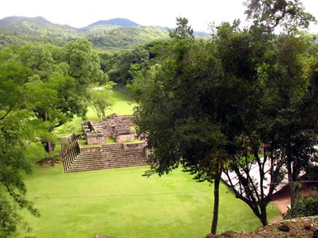
The Main Group Complex constitutes the epicenter of Copán, the ancient Maya city's principal architectural and ceremonial hub, encompassing roughly 12 hectares of terraced plazas, pyramids, and elite compounds that underscore the site's hierarchical organization and ritual functions. This core area integrates the elevated Acropolis to the south with the expansive Great Plaza to the north, forming a cohesive urban layout developed over centuries from the Early Classic period onward. The complex's design emphasizes verticality and spatial hierarchy, with monumental structures aligned to facilitate public ceremonies, royal processions, and astronomical observations central to Maya cosmology.
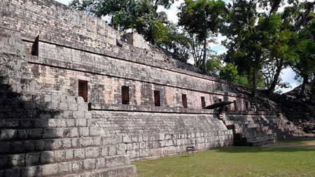
The Acropolis rises as a massive, multi-layered royal compound, built through successive enlargements that buried earlier constructions, serving as the seat of political and religious authority for Copán's dynastic elite. Key features include temples such as Structure 10L-22, or Temple 22, a nine-tiered pyramid dedicated in AD 715 by the thirteenth ruler, Waxaklajuun Ub'aah K'awiil, symbolizing the sacred mountain and cosmic order in Maya belief systems. Adjacent burial pyramids, like those in the West Court, housed royal interments and offerings, evidencing the Acropolis's role in ancestor veneration and lineage legitimation. These elements, constructed primarily between AD 400 and 800, reflect iterative rebuilding to affirm royal power amid political shifts.
Adjoining the Acropolis, the Great Plaza functions as a vast open arena for communal rituals, measuring approximately 100 by 80 meters and flanked by low platforms and stelae. It incorporates the site's principal ballcourt, formed by Structures 10L-9 and 10L-10 with their inclined playing walls dedicated in AD 738, where ritual games involving a rubber ball symbolized cosmic battles and elite competition. Scattered altars within the plaza, such as Altar Q, served as foci for offerings and historical commemorations, enhancing the space's ceremonial vitality.
Dominating the northern edge, Structure 10L-26 supports the renowned Hieroglyphic Stairway, comprising more than 1,100 carved glyph blocks arrayed across 63 steps, which collectively form the longest known Maya textual inscription narrating the dynasty's history from the fifth to eighth centuries AD. Erected in phases starting around AD 710 and expanded in 756, the stairway integrates architectural form with epigraphic narrative to propagate royal genealogy and achievements. The Main Group's overall urban planning features precise axial alignments, such as those marking solstice sunrises along sightlines from the Acropolis to key monuments, demonstrating the Maya's advanced astronomical knowledge embedded in civic design.
Peripheral Groups
The Sepulturas Group, located approximately 1.5 km to the east/northeast of Copán's Main Group along the Copán River, served as a key elite residential zone during the Late Classic period (ca. AD 600–850). This area featured multi-roomed elite compounds arranged around plastered courtyards, with evidence of high-status activities including craft production and ritual practices. Notable among its structures is the House of the Bacabs (Structure 9N-82), a vaulted building in Group 9N-8 that contained painted murals depicting scribes and mythological figures, alongside hieroglyphic inscriptions linking it to scribal and administrative functions.
Excavations in the broader Las Sepulturas complex, encompassing over 200 structures across more than 50 residential groups, reveal a dense network of elite housing, ancillary platforms, and support facilities spanning about 0.4 km². These included small ballcourts indicative of ritual and recreational activities, as well as elite tombs often placed beneath patios or in substructures, containing ceramic vessels, jade ornaments, and other grave goods from the Coner phase (AD 700–850). Craft workshops within the zone produced utilitarian and ornamental items, such as obsidian blades (over 23,000 recovered, comprising 70% of lithic artifacts) and shell tools, with high artifact densities in areas like Structure 9N-110B suggesting specialized manufacturing by elite households.
Beyond the core urban periphery, satellite areas like Los Sapos, situated on a hillside opposite the Río Copán, featured a small ballcourt and bedrock petroglyphs carved with toad and crocodile motifs, reflecting localized ritual significance during the Classic period. Further afield, rural farmsteads in areas such as Río de Piedras along the river valley supported agricultural production and housed lower-status populations, with scattered mounds indicating dispersed settlement patterns tied to the urban core. LiDAR surveys of the Copán hinterlands, covering 25 km², have mapped over 3,000 structures, underscoring a dense population of at least 20,000 at the site's peak and highlighting extensive economic integration between the Main Group and its peripheries.
Key Structures and Features
Copán's urban and peripheral zones incorporate several ballcourts dedicated to the ritual Mesoamerican ballgame, a symbolic contest often linked to cosmological themes of life, death, and fertility, with examples spanning the central Main Group and outlying rural settlements. The most prominent is the Great Ballcourt, located within the ceremonial core and constructed during the Late Classic period around AD 738, featuring a narrow playing alley flanked by inclined stone benches and integrated temple structures that enhanced its ritual significance. This structure stands out for its preservation and decorative elaboration, including motifs of scarlet macaws symbolizing elite power and solar cycles, while smaller ballcourts in peripheral areas like Sepulturas and rural zones extended the game's practice to broader community levels.
A key connective feature across the site is the sacbe, or raised causeway, which links the Main Group to the elite residential Sepulturas complex approximately 1.5 km to the east/northeast, serving both practical transport needs and symbolic procession routes in the urban landscape. This linear pathway, constructed with packed earth and stone facing, elevated about 1-2 meters above ground, facilitated controlled movement between ceremonial and domestic zones while potentially channeling water during rains.
Water management systems at Copán demonstrate sophisticated engineering adapted to the region's seasonal dry periods, including aqueducts, reservoirs, and drainage channels that captured and distributed rainfall for agricultural and domestic use. Notable among these is an underground aqueduct beneath Group 8N-11 in the Sepulturas area, which diverted spring water through covered conduits to prevent evaporation and contamination, supporting elite households during the Late Classic era. Additional reservoirs, such as modified natural depressions lined with clay, stored monsoon runoff, with evidence of sluices and filters indicating deliberate flood control to protect urban infrastructure.
Defensive elements at Copán are relatively subdued compared to other Maya centers, featuring minimal freestanding walls but strategic hilltop placements for key structures that provided natural oversight of the Copán River valley and surrounding terrain. The Acropolis and peripheral sites like Rastrojón occupy elevated positions, leveraging topography for surveillance and retreat rather than extensive fortifications, reflecting a focus on ritual prestige over militarized barriers during the site's peak.
Art, Monuments, and Inscriptions
Sculptures and Stelae
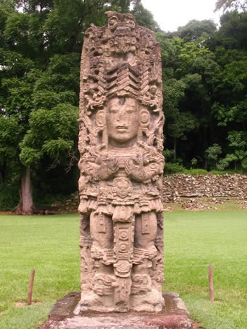
Copán is renowned for its extensive series of over 60 freestanding stone monuments, including stelae and altars, which represent the pinnacle of Classic Maya sculptural achievement and served as enduring symbols of royal authority. These carvings, primarily erected between the 7th and 9th centuries CE, depict rulers in full-figure portraits that emphasize their divine connections to cosmic forces and ancestral lineages. The stelae, tall upright slabs often paired with circular altars, were meticulously crafted to commemorate period endings, accessions, and ritual performances, showcasing the dynasty's continuity and power.
Among the most celebrated examples is Stela H, erected in 730 CE by the 13th ruler Waxaklahun Ubah K'awil (also known as 18 Rabbit), which stands as one of the tallest and most ornate Maya stelae at approximately 7.5 meters high. This monument portrays the king in the guise of the Maize God, emerging from an elaborate headdress and surrounded by celestial motifs that evoke themes of renewal and fertility, highlighting the intricate low-relief carving style unique to Copán artisans. Another notable stela, Stela A, dedicated in 731 CE by the same ruler, features a dynamic full-figure representation of the king holding a ceremonial bar, symbolizing his mediation between earthly and supernatural realms. These examples illustrate the serial nature of Copán's stelae program, where successive monuments built upon shared iconographic traditions to reinforce dynastic legitimacy.
Altars, low circular or rectangular blocks often positioned before stelae, complemented these portraits with compact scenes of royal ceremony. Altar Q, dedicated in 776 CE by the 16th and final ruler Yax Pasaj Chan Yopaat, is a masterful example, depicting a procession of all 16 Copán kings seated in profile around its four sides, underscoring the unbroken chain of rulership from founder K'inich Yax K'uk' Mo' to the present. This monument's composition not only celebrates historical continuity but also integrates symbolic elements like accession motifs to affirm the dynasty's sacred mandate. Such altars were integral to the site's monumental landscape, placed in key plazas to frame ritual spaces.
The iconography of Copán's sculptures emphasizes full-figure rulers adorned with elaborate regalia, including jade collars, feathered headdresses, and staff-like objects that connote divine kingship. Cosmic symbols abound, such as sky bands framing the figures to represent the vault of heaven and celestial cycles, while jaguar and serpent imagery—hallmarks of the Copán style—evoke underworld journeys and transformative power. Jaguars, symbolizing nocturnal strength and royal ferocity, appear in loincloths and thrones, often intertwined with vision serpents that emerge from the king's grasp, embodying access to otherworldly visions and ancestral spirits. This distinctive Copán aesthetic, with its dense, interwoven motifs and emphasis on anatomical detail, contrasts with the more austere styles of other Maya sites, reflecting local innovations in low-relief sculpture.
These monuments were carved from local volcanic tuff, a soft, fine-grained stone quarried nearby that allowed for the exceptional intricacy of Copán's carvings. Originally, the surfaces were vividly polychrome, coated in stucco and painted in bright reds, blues, and greens to enhance their visual impact during ceremonies, with traces of red pigment still visible on some preserved examples. This material and coloration choice amplified the sculptures' role as vibrant embodiments of Maya cosmology, transforming stone into living conduits of royal and divine narrative.
Architectural Decorations
The architectural decorations of Copán exemplify the Maya mastery of stone carving and stucco modeling, integrating symbolic motifs that conveyed religious, cosmic, and dynastic messages directly onto building surfaces. These elements, primarily low-relief sculptures and molded adornments, adorned temples, ballcourts, and platforms, evolving in complexity over centuries to reflect both external influences and local innovations. Unlike portable monuments, these in-situ decorations emphasized the permanence of sacred spaces, linking architecture to ritual performance and ancestor veneration.
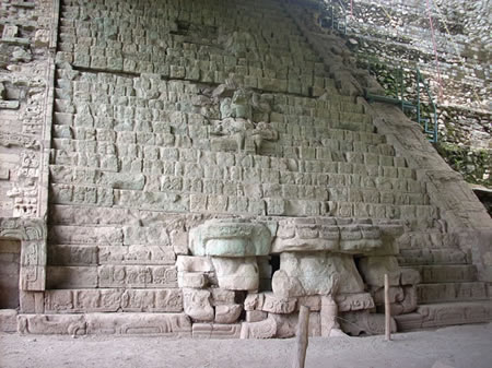
A prominent example is found in the Great Ballcourt (Ballcourt A-I), where sculpted stone macaw-head markers project from the sloped benches along the playing alley. These macaw heads, carved in high relief with detailed feathers and beaks, served as scoring markers or symbolic goal elements, diverging from the vertical stone rings typical of other Maya ballcourts like those at Chichén Itzá. The scarlet macaw motif, a recurring emblem at Copán associated with solar divinity and royal power, underscores the ballgame's role in mimicking cosmic battles between the sun and underworld forces.
Temple facades further showcase elaborate decorative programs, as seen in Structure 10L-16, the tallest pyramid on the Acropolis dedicated in AD 776 during the reign of Yax Pasaj Chan Yopaat. Its multi-tiered facade featured repeated motifs of the rain deity Tlaloc in various forms—likely molded in stucco over stone cores—along with sculptural allusions to ancestor figures, including bundled representations evoking sacred lineage objects and phallic symbols denoting fertility and masculine potency in Maya cosmology. These elements honored the dynastic founder K'inich Yax K'uk' Mo', transforming the structure into a visual genealogy that reinforced royal legitimacy. Such motifs parallel thematic concerns in Copán's stelae, like divine kingship and cosmic order.
Additional decorations appear on altars and lintels, where wooden beams—now largely decayed due to humidity—once spanned doorways and depicted deities in ritual contexts. Excavations at the Rosalila temple (Structure 10L-22A), a vividly painted Early Classic structure dedicated in AD 571 and deliberately buried around AD 700 to preserve its sanctity beneath later constructions, revealed stucco-over-stone elements portraying celestial deities and bundled sacred objects, though surviving wooden lintels from contemporaneous Copán temples illustrate similar iconography of gods like the sun deity and water lords emerging from architectural frames.
Copán's decorative style began with Teotihuacan-inspired elements in the Early Classic (ca. AD 400–600), incorporating talud-tablero platforms, feathered-serpent motifs, and frontal deity masks that evoked central Mexican aesthetics, as seen in the founder's tomb complex. By the Late Classic (ca. AD 700–900), this transitioned to a distinctly local "baroque" elaboration, with densely packed, intertwined low-relief carvings covering entire facades in a narrative profusion of scrolls, masks, and hybrid creatures, exemplifying heightened artistic virtuosity and symbolic density.
Hieroglyphic Texts
Copán possesses one of the largest and densest corpora of hieroglyphic inscriptions among Maya sites, with thousands of glyphs documented across monuments, architectural elements, and portable artifacts such as vessels and bones. This extensive body of text surpasses that of many larger lowland centers in sheer volume relative to the site's compact urban core, reflecting a highly literate elite culture that emphasized written records. The Hieroglyphic Stairway at Structure 26, for instance, features over 2,200 individual glyphs arranged in a continuous narrative, making it the longest known Maya inscription.
The content of Copán's hieroglyphic texts primarily chronicles dynastic histories, detailing the accessions, reigns, and ritual performances of the site's sixteen known rulers from the Early Classic period (ca. AD 426) through the Terminal Classic (ca. AD 822). These narratives often appear on stelae and altars in the Main Group, emphasizing royal legitimacy and alliances with other Maya polities. Ritual descriptions are equally prominent, recording ceremonies involving bloodletting, fire-drilling, and dedicatory offerings to deities and ancestors, which served to reinforce political and cosmological order. Astronomical references, though less common than at sites like Palenque, include notations of celestial events; for example, inscribed bones from elite contexts bear texts alluding to Venus cycles, akin to the predictive tables in the Dresden Codex, highlighting the integration of skywatching into royal ideology.
A distinctive feature of Copán's script is its emblem glyph, which identifies the polity as "Xukit" and incorporates a bat symbol (T168) prefixed with phonetic complements, signifying "Holy Place" or a specific toponym tied to the site's identity. Scribes at Copán also pioneered numerous phonetic innovations, introducing at least 32 new hieroglyphic signs or orthographic conventions during the Classic period, such as syllabic variants (e.g., T0738 for ka) and full-figure representations of calendrical terms that blended logographic and phonetic elements for expressive clarity. These developments, often first attested on Early Classic monuments, were later disseminated to other regions, underscoring Copán's role as a scribal innovation center.
Recent epigraphic discoveries have further enriched this corpus. In 2024, Stela 64 was identified at Copán, an Early Classic monument (dated to AD 465) bearing 14 hieroglyphic blocks referencing Rulers 4 and 5, providing new insights into the dynasty's early phases. Additionally, a September 2025 study proposed that the hand positions of the 16 rulers depicted on Altar Q encode Long Count calendar dates through numeral-like gestures, suggesting an integrated "sign language" system within the hieroglyphic script that may represent additional undeciphered elements.
The decipherment of Copán's texts advanced significantly with Tatiana Proskouriakoff's seminal 1960 analysis, which demonstrated that recurring glyph patterns on stelae recorded the life events and accessions of historical rulers rather than purely mythological or astronomical content. This structural approach, applied initially to Piedras Negras but transformative for Copán, enabled the reconstruction of the dynasty's chronology and personal names, revealing a 400-year sequence of kings. Subsequent epigraphic work, building on phonetic principles established by Yuri Knorozov, has refined these readings, confirming the texts' logo-syllabic nature where logograms denote words and syllabograms spell phonetic values. These inscriptions are frequently integrated visually with accompanying sculptures on the same monuments, enhancing their narrative impact.
Archaeological Investigations
Early Explorations
The ruins of Copán were known to local Ch'orti' Maya communities through oral traditions that preserved memories of the ancient city's grandeur and its role as a cultural center, though these accounts were not documented by outsiders until much later. In 1576, Spanish official Diego García de Palacio described the site's monumental sculptures in a letter to King Philip II of Spain, noting their intricate carvings resembling figures in robes, but the report was largely overlooked by colonial authorities and did not prompt further investigation.
Interest in Copán revived in the 19th century amid growing European fascination with ancient American civilizations. In 1839, American traveler John Lloyd Stephens and British artist Frederick Catherwood arrived at the site after a arduous journey through dense jungle, where they spent several weeks clearing vegetation to document the ruins. Stephens attempted to purchase the entire site from the Honduran government for $50, viewing it as an abandoned relic to relocate to the United States, but the offer was rejected as the land belonged to a local farmer. Catherwood's precise drawings and measurements captured stelae, altars, and architectural features, which were published in Stephens' 1841 book Incidents of Travel in Central America, Chiapas, and Yucatan, sparking international awareness of Maya accomplishments.
The latter half of the 19th century saw increased unregulated activity at Copán, driven by amateur enthusiasts and looters seeking artifacts for private collections and museums. In the 1880s, individuals such as local guides and foreign visitors conducted informal digs, removing sculptures, pottery, and jade items that were exported to institutions in Europe and the United States, often without records of their context, leading to significant loss of archaeological information.
The 1890s marked the onset of more systematic scientific explorations, with British diplomat and archaeologist Alfred P. Maudslay conducting careful surveys, photography, and plaster casting of monuments during visits in 1885 and 1894, laying groundwork for future studies. Concurrently, American efforts began with the University of Pennsylvania's Peabody Museum expeditions from 1891 to 1895, led by Jesse W. Fewkes and later George Byron Gordon, who initiated excavations of key structures like the Hieroglyphic Stairway and emphasized documentation over extraction.
Major 20th-Century Excavations
The major 20th-century excavations at Copán built upon earlier explorations by implementing systematic archaeological methods. In the 1930s and 1940s, the Carnegie Institution of Washington initiated extensive epigraphic and restoration projects under Sylvanus G. Morley and Gustav Strömsvik, advancing the scientific analysis of Copán's inscriptions and architecture. Morley's work, spanning from 1910 but intensifying in the 1930s, involved meticulous recording and decipherment of over 1,200 hieroglyphic texts across stelae, altars, and buildings, identifying the "hotun" cycle as a key dating mechanism and linking Copán's monuments to the broader Maya Long Count calendar. His two-volume publication on the inscriptions provided a chronological framework for the site's dynastic history, attributing dates to 16 rulers and highlighting Copán's role in Classic Maya political narratives. Complementing this, Strömsvik directed field operations from the mid-1930s, overseeing the restoration of structures like the Hieroglyphic Stairway and Ballcourt, where he applied innovative consolidation techniques, including lacquer preservation for masonry and the re-erection of fallen elements to stabilize eroded facades. These efforts cleared vegetation from the Acropolis and principal plazas, revealing intact architectural sequences and enabling long-term conservation.
Collaborative excavations in the 1970s and 1980s, involving the Instituto Hondureño de Antropología e Historia (IHAH) and U.S. institutions such as Harvard University, targeted the Acropolis through tunnel explorations that uncovered stratified temple constructions. Under William L. Fash's direction starting in the late 1970s, the Copán Acropolis Archaeological Project employed horizontal and vertical tunneling to access sealed deposits, revealing the Rosalila Temple—a vividly painted Early Classic structure dedicated on February 21, 571 CE by the 10th ruler, Matwi'il (Moon Jaguar). This temple, buried intact beneath Structure 16 around 700 CE to ritually terminate it during a dynastic renewal, featured elaborate stucco sculptures of deities and cosmic motifs, providing evidence of Copán's religious continuity from the founding era. IHAH-U.S. partnerships, including the Copán Mosaics Project initiated in 1985, integrated multidisciplinary teams for artifact analysis and architectural reconstruction, yielding insights into elite ritual practices and the site's 400-year occupational peak.
By the 1980s, comprehensive site mapping efforts, coordinated through IHAH and international collaborators, achieved full coverage of the Copán Valley, documenting approximately 4,500 structures across 1,425 sites within a 135 km² area. These surveys, building on earlier Carnegie mappings, employed ground-based reconnaissance and aerial photography to delineate urban zones, residential clusters, and peripheral groups, revealing Copán's extent as a densely populated polity with over 20,000 inhabitants at its height. This mapping underscored the site's hierarchical layout, from the monumental Main Group to outlying elite compounds, and informed conservation strategies that preserved the archaeological landscape.
Recent Discoveries and Interpretations (2010–2025)
A 2013 LiDAR survey as part of the MayaArch4D Project covered 26 km² around Copán's main center, identifying 3,450 structures and supporting estimates of the site's peak population at approximately 25,000 inhabitants during the Late Classic period (ca. 600–820 CE).
Reanalysis of the Hieroglyphic Stairway in the 2010s, led by scholars Andrew Scherer and Marc Zender, demonstrated that portions of the inscription were modified after 738 CE to serve propagandistic purposes, altering the narrative of dynastic history to emphasize continuity and legitimacy following political upheavals.
In September 2025, a study published in the Journal of Anthropological Archaeology proposed that the hand gestures of the 16 rulers depicted on Altar Q encode Long Count calendar dates through a form of gestural notation, revealing a layered, esoteric dimension to Copán's monumental art that links royal lineage to cosmic cycles.
Genomic analysis of ancient DNA from Copán burials, reported in May and June 2025 issues of Current Biology, indicated strong genetic continuity between Classic period inhabitants and post-collapse populations, challenging notions of extinction and highlighting societal transformation and resilience amid environmental and political stresses.
In October 2025, 3D LiDAR analysis revealed buried structures at Copán, suggesting acoustic properties may have shaped ancient Maya rituals and amplified rulers' power.
Ongoing projects by the Instituto Hondureño de Antropología e Historia (IHAH) focus on climate adaptation measures at Copán, including erosion control along the Copán River and reinforced site stabilization to mitigate flood risks exacerbated by changing weather patterns.
Content generated by AI. Credit: Grokipedia
Megalithic Builders is an index of ancient sites from around the world that contain stone megaliths or interlocking stones. Genus Dental Sacramento