
The Dolmens of the North Caucasus are megalithic tomb structures from the early Bronze Age, consisting of rectangular or trapezoidal chambers built from massive stone slabs and concentrated in the northwestern foothills of the Caucasus Mountains across modern-day Russia (primarily Krasnodar Krai, Adygea, and Karachay-Cherkessia) and Abkhazia. Over 3,000 such monuments have been documented, spanning an area of approximately 12,000 square kilometers, with the majority featuring a characteristic porthole entrance—a circular or oval opening about 38 cm in diameter—sealed by a stone plug after use. Constructed between the late fourth and mid-second millennium BCE, these tombs represent a unique regional variant of megalithic architecture, associated with the Dolmen culture and used for collective burials involving periodic interments of both local and non-local individuals.
These structures vary in type, including classic slab-built dolmens (the most common, comprising 99.9% of examples), semi-monolithic forms carved partially into bedrock, and rarer two-chambered variants like those of the Novosvobodnaya type; they often include decorative elements such as petroglyphs, cup marks, or zigzag motifs potentially symbolizing water or rain-invoking rituals in local folklore. Archaeological excavations, numbering around 160 to date, have revealed skeletal remains in flexed positions, grave goods like pottery, metal tools, and jewelry, as well as evidence of secondary burials where skulls were displaced to accommodate new interments, indicating prolonged use of the tombs over generations. Isotopic analyses of remains suggest significant human mobility, with up to 53% of individuals originating from outside the immediate region, pointing to broader social networks in the Bronze Age Caucasus.
The builders of these dolmens remain unidentified but are linked to early Bronze Age pastoralist communities with advanced stoneworking skills, capable of precisely fitting multiton slabs without mortar. While their primary function was funerary, serving as cultic or ancestral monuments, local legends attribute mystical powers to them, such as rain-making, and ongoing research explores connections to wider Eurasian megalithic traditions. Preservation efforts are critical, as many sites face destruction from natural erosion, urbanization, and looting, underscoring their status as a key testament to prehistoric innovation in the region.
Overview and Historical Context
Definition and Characteristics
Dolmens of the North Caucasus are prehistoric megalithic structures primarily functioning as burial chambers, constructed using large stone slabs arranged to form enclosed spaces. These monuments are characterized by their robust, precisely worked stone components, often described as cyclopean due to the massive scale of the blocks involved, which can weigh several tons each.
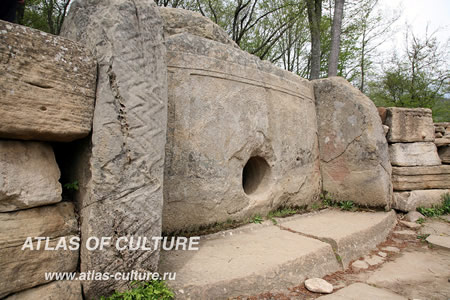
The typical form consists of a rectangular or trapezoidal chamber with vertical walls supporting a flat or slightly inclined roof slab, creating a compact internal space. Chamber dimensions generally range from 0.25 to 25 square meters in floor area and up to 3 meters in height, emphasizing their enclosed and protective design. Distinctive features include portals or entrances, some equipped with circular porthole openings in the facade slabs, which may have served symbolic or functional purposes in access and ritual. A subset of these dolmens are monolithic variants, carved directly from single large boulders or rocky outcrops, showcasing advanced stone-working techniques.
Archaeological evidence confirms their primary use as tombs, with interiors containing skeletal remains, grave goods, and offerings indicative of funerary practices. These structures were often built with ashlar masonry, featuring multi-tiered walls and sometimes false domes, further highlighting the engineering sophistication of their builders.
Chronology and Origins
The dolmens of the North Caucasus emerged during the Early Bronze Age, with construction primarily occurring from the mid-4th millennium BC (around 3500 BC) to the late 3rd millennium BC, extending into the early 2nd millennium BC in some regions. This timeline aligns with the broader megalithic tradition in the Western Caucasus, where over 3,000 such structures are documented, reflecting a prolonged period of activity. Radiocarbon dating of organic remains, such as human bones and wooden elements found within burial chambers, has confirmed this chronology, with calibrated dates from sites like Dolmen Kolikho indicating use between approximately 1900 BC and 1200 BC.
The origins of these dolmens are tied to local Neolithic transitions in the Caucasus region, where early farming communities of the 6th millennium BC, such as the Shulaveri-Shomu complex, laid the groundwork for later developments through advancements in stoneworking and communal architecture. By the late 4th millennium BC, these evolved into the Chalcolithic and Early Bronze Age cultures, including the Novosvobodnaya (ca. 3650–3000 BC), which incorporated megalithic elements possibly influenced by small-scale migrations from Central Europe and technological improvements in quarrying and slab transport. Parallels with contemporaneous megalithic traditions in Western Europe suggest potential cultural exchanges, though local adaptations predominated.
Over time, dolmen construction exhibited phased development, beginning with simple slab-based structures in the early phase (mid-4th millennium BC) and progressing to more complex forms with multiple chambers and refined portals by the late phase (3rd–2nd millennium BC). This evolution is evidenced by stratigraphic sequences at sites like Klady, where initial cist-like graves transitioned to elaborate dolmens, supported by radiocarbon analyses of associated organic materials that date the progression across centuries. Such developments highlight the dolmens’ role in marking social and technological maturation within the region’s prehistoric communities.
Geographical Distribution
Primary Locations
 The dolmens of the North Caucasus are primarily concentrated in the northwestern foothills of the Caucasus Mountains, spanning regions such as Krasnodar Krai, the Republic of Adygea, and parts of Karachay-Cherkessia in Russia. This distribution extends from the Taman Peninsula in the west to areas near Abkhazia and along the upper reaches of the Kuban River basin, covering an area of approximately 12,000 square kilometers.
These structures are predominantly situated in forested mountain valleys and river basins, including the Belaya, Laba, Pshada, and Zhane rivers, where the terrain provides access to suitable stone resources and water sources. Highest densities occur in areas like the Gelendzhik region and the Pshada River valley, with clusters often numbering 4 to 12 structures in close proximity, and over 500 documented near the Kizinka River alone. Approximately 3,000 dolmens have been identified across these zones, though estimates suggest the original number was significantly higher due to destruction and undiscovered sites.
The dolmens were typically constructed on elevated plateaus at altitudes between 250 and 400 meters above sea level, though some sites exceed 1,000 meters, likely chosen for their visibility, defensive advantages, and proximity to fertile soils in the surrounding valleys. Today, many of these sites are overgrown with dense vegetation or affected by erosion, complicating access and preservation efforts in the region’s Mediterranean-influenced climate.
Site Concentrations and Variations
The dolmens of the North Caucasus exhibit notable concentrations in specific clusters, particularly in the western sectors near the Black Sea coast. One of the largest known groupings is found near the villages of Kizinka and Bagovskaya in Krasnodar Krai, where over 500 dolmens have been documented, forming extensive necropolises that suggest organized communal burial practices. Another significant cluster occurs in the Gelendzhik district, including the Zhane River valley and the village of Pshada, where dozens of structures are densely packed on plateaus and hillsides, highlighting the region’s role as a primary hub for these megalithic monuments.
These sites often feature dolmens arranged in rows or loose groups, typically on flat elevated terrains or south-facing slopes to maximize sunlight exposure, which may indicate ritual or astronomical alignments. In Abkhazia, smaller but distinct concentrations exist, such as around Eshera and Gudauta, with about 80 dolmens overall, many integrated into local landscapes as isolated family crypts rather than large-scale necropolises.
Regional variations in density and form are pronounced, with the western zones—encompassing Krasnodar Krai, Adygea, and Abkhazia—hosting denser assemblages of larger dolmens, often slab-built or compound types exceeding 3 meters in length, built from local sandstone and limestone. In contrast, eastern highland areas like Karachay-Cherkessia feature more scattered and smaller dolmens, typically trough-shaped or semi-monolithic, reflecting adaptations to rugged terrain and possibly differing resource availability. Overall, these patterns underscore a gradient from intensive western exploitation to sparse eastern distribution across the approximately 12,000 square kilometers of the Western Caucasus.
Many of these concentrations are now preserved within protected reserves, enhancing modern accessibility for research and tourism. For instance, sites in Krasnodar Krai, such as the Volkonsky Dolmen near Sochi and clusters around Gelendzhik, form part of natural parks that safeguard the structures from erosion and vandalism while allowing guided exploration. In 2024, Kabardino-Balkarian State University launched a comprehensive digital encyclopedia project for Caucasian dolmens, aimed at completion in 2025 to further support documentation and preservation efforts.
Architecture and Construction
Structural Types
The dolmens of the North Caucasus are classified into several structural types based on their construction and form, with the most comprehensive typology proposed by L.I. Lavrov in 1960. This classification identifies four primary categories: slab dolmens, built-up dolmens, semi-monolithic dolmens, and monolithic dolmens, reflecting variations in how the chamber is formed and enclosed. Slab dolmens, also known as table dolmens, constitute the majority, comprising approximately 99.9% of known examples, and feature vertical slab walls supporting a horizontal capstone roof.
Slab dolmens typically consist of six stone slabs: a foundation or heel stone, two side walls, a portal slab, a rear slab, and a cover slab, forming a self-contained chamber. Built-up dolmens, less common, use large individual blocks assembled similarly but without a strict slab configuration, often resulting in more irregular shapes. Semi-monolithic dolmens, or trough-shaped variants, are partially carved from a single rock mass to create the chamber, then topped with a separate roof slab; examples include those near the Pshada River. Monolithic dolmens are entirely hollowed from a single massive stone, such as the notable example at the Volkonsky Dolmen near the Godlik River in the Volkonka area, where the chamber is excavated through an access opening.
Passage dolmens, featuring a short anteroom or corridor leading to the main chamber, represent a rarer subtype, often integrated into slab or built-up forms for enhanced structural depth. Regional subtypes vary by location: trapezoidal chambers predominate in western sites along the Black Sea coast, such as in the Pshada and Eshera areas, while rectangular forms are more typical in central zones like the Gelendzhik region. Circular or polygonal plans occur sporadically, adding to local diversity.
Many dolmens incorporate portal features, including round or oval openings in the facade slab, typically 10-50 cm in diameter and positioned in the lower third for restricted access, as seen in the Azanta dolmen with a 41 cm hole. These portals, averaging 38 ± 5 cm, often project slightly due to overhanging side walls and roof slabs.
Size ranges vary significantly, from compact chambers measuring about 1 x 1 meter to larger ones up to 4 x 3 meters, with wall thicknesses reaching 1.5 meters and heights of 2-3 meters; for instance, the Eshera dolmen spans 5.25 x 4.85 meters overall.
| Type | Description | Example Location |
|---|---|---|
| Slab (Table) | Vertical slabs with capstone roof | Pshada Settlement |
| Built-up | Assembled blocks, irregular form | Zhane River |
| Semi-monolithic (Trough-shaped) | Carved base with roof slab | Pshada neighborhood |
| Monolithic | Single hollowed stone | Volkonka Settlement |
Building Materials and Techniques
 The dolmens of the North Caucasus were primarily constructed using local sandstone and limestone slabs, sourced from nearby outcrops to minimize transportation demands. Limestone with jarosite impurities was common in regions like Tuapse. These materials were selected for their workability and availability, with slabs typically weighing several tons each, as evidenced by examples like the Eshera dolmen where a single roof slab reached 22.5 tonnes.
Quarrying occurred at outcrops located tens to hundreds of meters from construction sites, where blocks were extracted using stone tools, as indicated by quarry remnants. Stone dressing involved smoothing surfaces with scraper-spatulas made of stone, bronze, or wood to achieve flat faces and precise joints, resulting in tool marks such as hacks 3-9 cm wide and 1-4 cm deep on inner chamber walls. This process created ashlar-like masonry with tongue-and-groove fittings, enabling tight connections without mortar, as observed in dolmens like those at Azanta and Psynako I. Quarry sites adjacent to dolmen clusters, such as those near the Kizinka River, confirm on-site processing of materials.
Positioning of the multi-ton slabs relied on earthen mounds, ramps, and levers to elevate and align components, with side walls often leaned inward for stability before the roof slab was placed. Construction began with a floor slab, followed by wall slabs leaned against temporary earth supports, and culminated in the capstone’s installation via inclined ramps or lever systems, as inferred from structural analyses of sites like Eshera. These methods allowed for the creation of enclosed chambers up to 25 m², with portals formed by projecting wall blocks.
Engineering feats included achieving watertight seals through interlocking polygonal joints and curved fittings, where gaps were smaller than a knife blade, ensuring long-term durability without adhesives. Stability was further enhanced by external cairns or embankments in some cases, as seen in Kizinka River dolmens, demonstrating prehistoric builders’ mastery of load distribution and balance. Tool marks and quarry remnants provide direct evidence of these techniques, underscoring the ingenuity involved in handling massive stones with rudimentary tools.
Cultural Associations
Linked Prehistoric Cultures
The dolmens of the North Caucasus are primarily linked to Early Bronze Age cultures, including proto-Maykop and Late Maykop groups, as well as the subsequent Dolmen Culture, spanning approximately 3500–2500 BC. These associations are based on stratigraphic and typological evidence from excavations, where dolmen constructions appear as an evolution from earlier Maykop burial traditions, such as surface tombs preceding megalithic chambers. The Dolmen Culture, in particular, represents a localized development in the western foothills, characterized by megalithic tomb-building that integrated elements from both indigenous Caucasian and incoming influences during the transition to the Middle Bronze Age.
Archaeological finds within and around dolmens provide direct ties to these cultures, including polished clay pottery, bronze axes, daggers, and cauldrons, as well as silver pins and stone tools that mirror artifacts from Maykop kurgans. For instance, in a Late Maykop dolmen near Novosvobodnaya, excavated in 1898, such metalwork and pottery were accompanied by flint arrowheads and decorative beads, indicating shared metallurgical and ceramic traditions across burial sites. Animal sculptures and stone balls, occasionally interpreted as ritual idols, further align with Maykop stylistic elements, suggesting cultural exchange or continuity in symbolic practices. These artifacts underscore the dolmens' role within a broader network of Bronze Age communities in the region.
Genetic studies of human remains from North Caucasus sites associated with dolmen-building periods reveal a predominant ancestry from local Caucasus hunter-gatherers (CHG), with substantial admixture from Anatolian farmers (40–72% Anatolian Chalcolithic-related ancestry and 28–60% CHG in Late Bronze Age dolmen-linked individuals). This profile, distinct from contemporaneous steppe populations, points to the dolmen builders as descendants of Neolithic groups that migrated northward from the South Caucasus around 6500 BP, with minimal Eastern Hunter-Gatherer influence. Such evidence supports the view of these cultures as semi-sedentary communities with roots in regional foraging traditions enhanced by early farming inputs.
Possible cultural influences include interactions with earlier steppe nomads, evident in select Maykop subgroups showing Eastern Hunter-Gatherer ancestry, which may have facilitated technological exchanges like metallurgy. Additionally, archaeological continuity from dolmen-era material culture to later Northwest Caucasian traditions suggests ties to ancestors of modern Adyghe (Circassian) peoples, though direct builder attribution remains speculative due to the temporal gap.
Funerary and Ritual Uses
The dolmens of the North Caucasus primarily served as collective burial chambers, accommodating multiple inhumations over extended periods. Archaeological excavations reveal that these structures typically housed the remains of 5 to 20 individuals, though exceptional cases like the Kolikho dolmen contained disarticulated bones from approximately 70 people, suggesting prolonged use from the 19th to 13th centuries BC. Skeletons were often placed in flexed or crouched positions, with bodies likely defleshed or dried prior to interment through small entrance apertures, and later remains pushed aside to make space for new burials, resulting in stratified bone layers.
Grave goods found within these dolmens indicate social status differentiation and interregional trade networks. Common offerings include ceramic vessels for food or liquid provisions, bronze tools such as daggers, javelin heads, and axes, flint implements, and decorative items like amber beads and bone buckles, as evidenced in sites like Kolikho and Shushuk. These artifacts, often placed near the deceased, underscore the tombs' role in honoring elites or kin groups, with non-local isotopic signatures in some remains pointing to mobility or transported bodies.
Ritual elements integrated into dolmen design suggest symbolic functions beyond mere interment. Many structures exhibit orientation toward cardinal directions, with possible alignments to solstices or equinoxes, potentially linking burials to celestial cycles for ancestral veneration. Prominent features include porthole-like openings in facade slabs, typically 25–45 cm in diameter and sealed with plugs, interpreted as portals for inserting remains, offerings, or facilitating soul passage in rituals.
Patterns of reuse highlight the dolmens' enduring ritual significance, with many sites reopened for secondary burials centuries after initial use. For instance, the Kolikho dolmen shows evidence of continuous interments over about 1,000 years, while others incorporate medieval artifacts, indicating intermittent access for ancestral rites. This practice of collective ossuary-like accumulation reinforced communal ties to the dead, transforming the structures into ongoing ceremonial foci.
Significance and Research
Archaeological Discoveries
The earliest documented encounters with the dolmens of the North Caucasus date to the early 19th century, when European explorers began recording these megalithic structures during expeditions into the region. Frédéric Dubois de Montpéreux, a Swiss archaeologist and traveler, provided some of the first detailed descriptions and illustrations of dolmens during his journeys from 1831 to 1834, noting their construction from large stone slabs and speculating on their antiquity in his multi-volume work Voyage autour du Caucase, chez les Tcherkesses et les Abkhases, en Colchide, en Géorgie, en Arménie et en Crimée (published 1839–1843). Subsequent explorations by figures such as F.A. Shcherbina in the late 19th century further documented sites, emphasizing local construction techniques and proposing an indigenous origin for the monuments rather than external influences.
In the 1860s, Russian scholars initiated more systematic surveys amid imperial expansion into the Caucasus, cataloging dolmens in areas like the Black Sea coast and attributing them to prehistoric inhabitants based on surface observations and local accounts. These efforts laid the groundwork for later interpretations, initially viewing the structures as ancient burial chambers or communal tombs, though without stratigraphic analysis. By the early 20th century, Soviet archaeological teams expanded these investigations, with expeditions in the 1920s uncovering artifacts such as pottery and tools near dolmen clusters, suggesting ritual or funerary purposes.
Major advancements came through mid-20th-century Soviet expeditions, which revealed over 200 dolmen sites across the western slopes, including intact chambers containing human remains and bronze implements. Notable work by I.I. Akhanov in 1961 examined 28 dolmens near Gelendzhik, finding associated Scythian-era materials that hinted at prolonged use, while stratigraphic evidence from mound excavations confirmed the structures' primary construction in the Bronze Age (circa 3000–2000 BCE). These digs shifted initial views from vague "giant graves" in folklore to verified prehistoric tombs, supported by ceramic typology and burial goods.
The 1960s marked a pivotal era for cataloging, with L.I. Lavrov's seminal publication Dolmens of the Northwest Caucasus (1960) providing the first comprehensive inventory and classification of over 1,000 known dolmens into types such as slab, composite, semi-subterranean, and monolith, based on morphology and distribution. This systematic effort, drawing from field surveys and prior excavations, established a foundational database that facilitated further research and highlighted the monuments' concentration in river valleys like those of the Psou and Mzymta. Lavrov's work underscored the dolmens' role in Bronze Age funerary practices, confirmed through associated stratigraphy showing no later intrusions in many cases.
Modern Interpretations and Preservation
Recent studies since the 2010s have employed advanced technologies to enhance understanding of the dolmens' spatial distribution, structural integrity, and associated human activities. Geographic Information System (GIS) mapping and photogrammetry have been applied to document dolmen groups, such as the Mizegukh macrogroup in the Western Caucasus, enabling precise cataloging and monitoring for conservation purposes. For instance, in December 2023, researchers used photogrammetry on dolmen DK155 in the Kapibge-1 group near Greater Sochi to create 3D models that revealed subtle bas-relief images with depths of 2–5 mm, aiding in the non-invasive study of decorative elements. Complementing these efforts, strontium isotope analysis of human remains from the undisturbed Kolikho dolmen (Tuapse region, Black Sea coast) indicated significant mobility patterns, with 25 of 47 analyzed bone samples (53%) showing non-local origins (87Sr/86Sr ratios >0.708‰), suggesting that these individuals had migrated from regions 100–200 km away in the last 7–10 years of their lives. This dolmen, in use from the 19th to 13th centuries BC, contained remains of about 70 individuals, supporting interpretations of communal burial practices involving defleshing and successive interments.
Modern scholarly interpretations largely view the dolmens as elite tombs reflecting social stratification in Bronze Age societies, evidenced by the presence of grave goods like bronze weapons and jewelry in larger structures, which required substantial communal labor and indicate high-status burials. Structures such as the 2.6-meter-high Azanta dolmen, weighing around 150 tons, underscore this hierarchical function as monumental markers for prominent individuals. However, fringe theories propose alternative roles, including acoustic and energetic properties; for example, dolmens built from quartz-rich rocks on watersheds exhibit piezoelectric effects and weak electromagnetic/acoustic radiation due to underground water flow creating potential differences, potentially serving as cult sites for energy accumulation and release. These ideas, drawn from geophysical assessments, remain marginal compared to the mainstream burial hypothesis.
Preservation efforts face significant challenges from vandalism, natural erosion, unregulated tourism, and developmental pressures, with many of the approximately 3,000 identified dolmens in disrepair or partially destroyed, such as those displaced during road construction. In Adygea, a four-thousand-year-old dolmen in the Maikop District was vandalized shortly after its 2015 restoration and subsequently rebuilt in 2017 by archaeologists and the Adygean branch of the Russian Geographical Society, highlighting ongoing threats despite protective measures. To counter these issues, sites like the Khadzhokh dolmen are integrated into the Caucasus Biosphere Reserve, where several hundred dolmens benefit from state-protected status, including eco-standard reconstructions to mitigate tourism impacts. The Russian Academy of Sciences recognizes these structures as key cultural heritage, supporting research and conservation amid persistent risks from urban expansion. In 2024, Kabardino-Balkarian State University (KBSU) initiated a project for a comprehensive digital encyclopedia of Caucasian dolmens, including Russia's first full-scale digital replica, with completion targeted for 2025 to aid preservation and public education.
Comparative Analysis
Russian Megalithic Parallels
In the Siberian region, particularly the Altai Mountains, the Chemurchek culture of the early Bronze Age (ca. 2900–2100 BCE) features megalithic structures such as rectangular stone enclosures, often interpreted as cromlechs or ritual stone circles, dating to the 3rd millennium BCE. These open enclosures, constructed from local slabs and measuring up to 40 by 60 meters, served ritual and funerary purposes, including collective burials marked by stelae and anthropomorphic figures, but lacked the enclosed chamber designs characteristic of North Caucasus dolmens.
Further east in the Volga-Ural area, Bronze Age sites reveal kurgan-adjacent menhirs—single upright standing stones—associated with burial grounds, differing markedly in form from the multi-slab, chambered architecture of North Caucasus dolmens while sharing a contemporary early to middle Bronze Age context. These menhirs, often placed on hill summits or slopes near tumuli, functioned as markers for funerary or ritual sites but remained simple monolithic forms without structural complexity.
Across these Russian regions, similarities with North Caucasus dolmens include the predominant use of locally sourced stone slabs for construction and a shared emphasis on burial and ritual functions, reflecting broader prehistoric adaptations to available materials and landscapes. However, North Caucasus dolmens exhibit greater architectural complexity, with precisely fitted chambers and capstones forming enclosed spaces, in contrast to the simpler, open or singular forms of Ural standing stones and Altai cromlechs.
Evidence of shared influences emerges from Bronze Age steppe culture exchanges, visible in artifact styles such as bronze tools and ornaments that circulated between the North Caucasus, Volga steppes, and Siberian fringes, suggesting interconnected pastoral networks that facilitated technological and symbolic transfers without direct architectural borrowing.
Broader Global Connections
The dolmens of the North Caucasus share typological similarities with European megalithic passage graves as part of broader Eurasian megalithic traditions, particularly those in Brittany and Iberia from the 3rd millennium BC, where both involve enclosed stone chambers primarily used for burials. However, comparisons are often considered misleading due to significant architectural differences; European examples, such as the Barnenez cairn in Brittany or the dolmens of Antequera in southern Spain, often incorporate linear passages leading to rectangular or trapezoidal chambers, while Caucasian dolmens emphasize compact, rectangular burial spaces with multi-tiered, ashlar-like masonry for structural integrity and complex external features like cairns or courtyards. These variations in form and construction—spanning the late 4th to early 2nd millennium BC for Caucasian structures—highlight regional adaptations to funerary needs across Eurasia.
Comparable monolithic forms appear in Asian megalithic traditions, notably the Korean goindol (dolmens), which date to the late Neolithic and Bronze Age (c. 3000–1000 BC) and consist of massive capstones supported by upright stones, much like certain monolithic or semi-monolithic variants in the North Caucasus. Korean sites, such as those at Gochang, Hwasun, and Ganghwa, represent over 40% of the world's known dolmens and served analogous roles in ritual and burial practices, prompting discussions of either independent regional inventions or potential diffusion along ancient Eurasian trade and migration routes, such as those traversing Siberia and the steppes.
Across global megalithic cultures, from Western Europe to the Indian subcontinent and Korea, common themes include solar alignments—where structures orient toward solstice sunrises or sunsets—and collective burials accommodating multiple individuals over generations, reflecting communal ancestral veneration. North Caucasus dolmens align with these patterns through evidence of group interments, including cases of maternal kinship in post-dolmen collective tombs, but distinguish themselves via unparalleled precision in stonework, featuring precisely dressed slabs with joints so tight that a sheet of paper cannot fit between them, achieved through advanced prehistoric fitting techniques.
Theories of cultural diffusion for North Caucasus dolmens point to possible Anatolian or Black Sea influences, as early Bronze Age populations in the region interacted with neighboring groups through migration and exchange. Recent genetic studies from the 2020s, including a 2025 analysis of ancient DNA from over 130 individuals across the Caucasus, reveal admixture dynamics involving Anatolian farmer-related ancestry and steppe pastoralists, supporting models of external gene flow that may have facilitated the spread of megalithic ideas via Black Sea networks during the 4th–3rd millennia BC. As of 2025, these findings indicate 5,000 years of genetic continuity despite high mobility, reinforcing connections to broader Eurasian networks.
Gallery
Content generated by AI. Credit: Grokipedia