
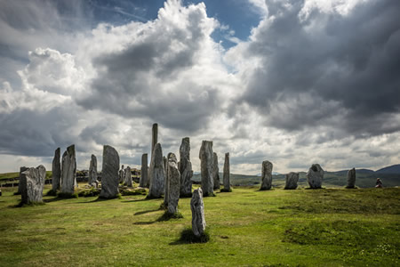
The Callanish Stones, also known as the Calanais Standing Stones, form a prehistoric complex of megalithic monuments on the Isle of Lewis in Scotland's Outer Hebrides. Erected during the late Neolithic period between 2900 and 2600 BCE, the site consists of a central stone circle of about 12 meters in diameter comprising 13 tall slabs of local Lewisian gneiss, surrounding a chambered tomb about 6.4 meters long, with five long rows of additional standing stones radiating outward in a distinctive cross-shaped pattern, totaling around 49 stones in the main arrangement.
This monument ranks among the most significant Neolithic sites in Britain, predating the primary phase of Stonehenge by approximately 500 years and representing one of the earliest examples of large-scale stone circle construction in the region. The complex likely served multiple purposes over time, including ceremonial rituals, as evidenced by the deposition of Grooved Ware pottery and cremated human remains in the central cairn, and possibly astronomical observations, with alignments suggested for lunar standstills and solstices along the avenues and rows. Construction occurred in phases, beginning with pre-ring cultivation beds and a green clay platform around 3000 BCE, followed by the erection of the ring and avenues, and later additions like enclosures and secondary cairns extending into the Early Bronze Age by 2000 BCE.
Archaeological excavations between 1979 and 1988, led by Historic Scotland, uncovered over 300 lithic artifacts including arrowheads and scrapers, along with pollen evidence of early cereal cultivation and radiocarbon-dated charcoal confirming the site's multi-millennial use. The stones, some reaching heights of over 4 meters, were quarried from nearby bedrock and erected in stone-lined pits, with the site's layout possibly symbolizing a ritual landscape tied to community identity and seasonal cycles. As of 2025, managed by Historic Environment Scotland as a scheduled ancient monument, the site remains open to visitors despite the visitor centre being closed for redevelopment as part of the Calanais 2025 project, expected to reopen in 2026, attracting visitors for its dramatic setting amid peatlands and its enduring cultural resonance in Hebridean heritage.
Site Overview
Location and Setting
The Callanish Stones are situated on the west coast of the Isle of Lewis in the Outer Hebrides, Scotland, near the modern village of Callanish, known in Gaelic as Calanais. The site occupies precise coordinates of 58°11′51″N 6°44′29″W. It rests on a low ridge at an elevation of about 15 meters above sea level, providing panoramic views over Loch Roag to the south and east.
The monument integrates into a landscape characterized by extensive peat bogs, scattered lochs, and undulating terrain shaped by ancient geological processes. The standing stones themselves were quarried from local Lewisian gneiss, a durable metamorphic rock dating back over 3 billion years and forming part of the Precambrian Hebridean terrain exposed across the region. This gneiss, with its banded textures from intense heat and pressure, reflects the area's deep geological history, including episodes of glaciation that sculpted the underlying landscape.
Following the retreat of post-glacial ice sheets around 10,000 years ago, the local environment underwent significant transformation, with rising sea levels and climatic shifts leading to widespread peat accumulation across the Outer Hebrides. At Callanish, this peat buildup began around 1000 BC, eventually burying portions of the site under layers up to 1.5 meters thick and obscuring the stones until systematic clearance in the 19th century. The broader Callanish complex includes nearby sites such as Callanish II and III, connected within this peat-influenced Neolithic landscape.
Management and Access
The Calanais Standing Stones are designated as a Scheduled Ancient Monument under the Ancient Monuments and Archaeological Areas Act 1979, with protection initially granted in 1882 to safeguard the site's archaeological integrity, and are currently managed by Historic Environment Scotland to ensure long-term preservation. The adjacent visitor centre, which provides educational resources on the site's history, is owned and operated by Urras nan Tùrsachan, a local charitable trust formed in 1994 to promote community involvement in heritage management.
Visitor facilities at the site include an on-site interpretation centre featuring exhibits on Neolithic culture, a café, and a gift shop, though the centre has been closed since late 2024 for major redevelopment and is scheduled to reopen in 2026 with enhanced amenities. Prior to the COVID-19 pandemic, the site attracted around 45,000 visitors annually, a figure that has since risen to approximately 150,000 per year as of 2024 due to increased tourism interest.
Access to the standing stones themselves remains free and unrestricted year-round, with visitors encouraged to adhere to marked paths to minimize soil erosion from foot traffic. Seasonal guided tours, offered by Urras nan Tùrsachan when the centre is operational, provide in-depth historical context, while temporary parking limitations and coach restrictions are in place during the redevelopment to manage site capacity. Entry to the visitor centre incurs a fee when open, supporting operational costs, though no admission charge applies to the monument.
Conservation efforts face ongoing challenges from intensified tourism, which has accelerated erosion around the stones, compounded by the site's exposure to severe Atlantic weather patterns and the need for sustained funding to cover maintenance and monitoring. Historic Environment Scotland has proposed potential entry fees in the future to address these pressures and finance protective measures, such as enhanced fencing and climate resilience initiatives.
Physical Description
Central Monolith and Circle
At the heart of the Callanish Stones lies a prominent central monolith, erected from local Lewisian gneiss, one of the oldest rock types in Europe dating back approximately three billion years. This stone stands approximately 4.8 meters tall with a roughly rectangular cross-section that tapers toward the top, measuring about 1.5 meters in width and 0.3 meters in thickness; it leans slightly to the west and is positioned 0.8 meters off the true center of the surrounding circle.
Encircling the monolith is an elliptical ring of 13 standing stones, also fashioned from Lewisian gneiss, which exhibits characteristic banding from alternating layers of quartz and darker minerals like hornblende. The circle measures roughly 13.4 meters by 11.8 meters, with 11 stones remaining upright and two having fallen; the standing stones vary in height from 2.5 to 4 meters, averaging around 3 meters.
The stones were installed by digging sockets into the peaty soil and propping them upright with smaller packing boulders, relying on their naturally shaped slabs without signs of artificial carving or tooling beyond selection for form. The central monolith's placement emphasizes it as the focal element of the circle, which forms the core of the site's broader cruciform arrangement.
Northern Avenue
The Northern Avenue extends northward from the central stone circle at the Callanish Stones, forming a prominent linear arrangement of standing stones that serves as an approach to the monument. Composed of two roughly parallel rows, the avenue measures approximately 83 meters in length and narrows as it approaches the circle, creating a funneling effect that guides movement toward the core of the site.
The avenue consists of 19 stones in total—10 along the western side and 9 along the eastern side—with heights ranging from 1 to 3.5 meters, the tallest positioned near the entrance to the circle. These stones are quarried from local Lewisian gneiss, the same material used in the central circle, and are set with deliberate spacing to maintain the parallel alignment. Some stones appear paired or positioned in close proximity within their rows, enhancing the structured pathway.
Archaeological evidence indicates that the Northern Avenue was constructed as part of a later phase following the erection of the stone circle and chambered tomb, likely between 2400 and 2200 BC, though using the same gneiss sources and techniques. This design creates a visually striking processional route, silhouetted against the surrounding Lewis landscape and emphasizing the monument's ceremonial function.
Arm Rows
The arm rows at the Callanish Stones form three shorter linear extensions radiating from the central stone circle, creating a cruciform pattern that distinguishes the monument's overall layout. These rows—the eastern, southern, and western—are composed of local Lewisian gneiss, the ancient metamorphic rock prevalent in the region, and their stones are set in sockets that are generally shallower than those of the main northern avenue, suggesting differences in construction or later disturbance.
The eastern row extends east-northeast for approximately 23 meters and consists of five standing stones, with the outermost stone having fallen and been re-erected after discovery in 1977. This alignment is less uniform in spacing and height compared to the northern avenue, potentially reflecting intentional asymmetry or post-construction alterations, though it contributes to the site's balanced cruciform symmetry when viewed from the center.
The southern row, oriented south-southeast, measures about 24 meters in length and includes five stones of varying heights up to around 3 meters. Archaeological evidence indicates partial dismantling in this arm, with some sockets showing signs of reuse or disturbance from historical peat cutting activities in the surrounding landscape.
The western row runs west-northwest for roughly 21 meters and features six stones, though some are fallen, buried, or displaced, leading to incomplete visibility today. Like the other arms, its stones are placed in relatively shallow sockets, and excavations have revealed traces of deliberate modification or erosion affecting their original placement, underscoring the rows' role as secondary elements in the monument's ritual design.
Chambered Cairn
 The chambered cairn at Callanish is embedded within the southeastern arc of the main stone circle, positioned between two standing stones (Rings 42 and 43) that serve as its portals. This integration suggests the cairn was constructed utilizing elements of the pre-existing circle, with its entrance facing eastward toward the interior of the monument.
The cairn is a horned type featuring a short passage leading to a main oval chamber, originally with walls that were later squared off, and a smaller rectangular rear chamber divided into three compartments by jamb stones. Measuring approximately 6 meters in length by 3 meters in width, it was built over the remains of a destroyed earlier stone circle or enclosure, with the inner core constructed solidly from large, rough, unhewn stones reaching up to 0.5 meters in height, surrounded by an outer layer of looser earth and stones. A partial kerb of massive slabs was added later, potentially forming the horned facade, while the internal passage contained possible cremation deposits alongside later Beaker pottery and barbed-and-tanged arrowheads, indicating reuse. The structure shows evidence of Victorian-era rebuilding and disturbance, including a modern drain in the passage.
As a Neolithic construction of stones and earth, the cairn postdates the main stone circle, erected after 2500 BC on an imported green clay platform that overlaid earlier turf lines and timber structures. Its architectural form is unique among Western Isles monuments but parallels chambered tombs in Orkney and Caithness, such as Maes Howe, with similar passage and multi-compartment designs. The cairn lies in close proximity to the southern row of stones extending from the circle.
Archaeological Investigations
Dating and Chronology
The primary construction of the Callanish Stones, including the central stone circle and monolith, occurred during the Late Neolithic period, dated to approximately 2900–2600 BC through radiocarbon analysis of charcoal samples recovered from post-holes and plank-holes associated with the stone settings. These dates, calibrated from uncalibrated radiocarbon measurements such as 4210 ± 50 BP (AA-24966) and 4140 ± 45 BP (AA-24959), indicate a rapid erection phase likely spanning no more than a century around 2900 BC, supported by stratigraphic evidence of sequential building. Antler tools found in similar contexts at Neolithic sites in the region have also contributed to this chronology, though direct antler samples from Callanish excavations yielded limited datable material.
The site's use extended beyond initial construction, with ritual activities continuing into the Early Bronze Age until around 1500–1000 BC, as evidenced by later radiocarbon dates from associated deposits, such as 3580 ± 45 BP (AA-24956) for ard marks and 1940–1690 cal BC for heather twig charcoal in activity layers. The chambered cairn was added subsequently around 2500 BC, based on associated pottery and stratigraphic context indicating construction against the central monolith, with later rebuilds and use extending into the Early Bronze Age. This chronology aligns with the presence of Grooved Ware pottery in early layers, linking the site to broader Neolithic traditions in northern Scotland.
Abandonment appears to have been gradual, with significant decline by around 800 BC, coinciding with cultural shifts toward new settlement patterns, as marked by the onset of peat accumulation over the site dated to 1050–400 cal BC from basal peat samples (e.g., 2640 ± 110 BP, GU-1403). Dating relies primarily on radiocarbon measurements from excavations, complemented by stratigraphic analysis of soil layers and pollen profiles, which show a transition from open ground use to vegetational overgrowth. Dendrochronology was not feasible due to the scarcity of preserved wood suitable for tree-ring analysis at the site. Overall, these methods establish a timeline of active use spanning roughly 1400 years, from late Neolithic erection to Bronze Age extension.
Major Excavations
The initial major exploration of the Callanish Stones occurred in 1857, when the landowner, Sir James Matheson, ordered the removal of approximately 1.5 meters of overlying peat, revealing the full height of the standing stones and uncovering the central chambered cairn for the first time. This clearance was not a systematic archaeological excavation but a practical effort to expose the monument, with limited probes conducted by antiquarians in the preceding decades, such as Jens Jacob Asmussen Worsaae's 1846 visit and sketch, which provided early documentation but no in-depth digging. These 19th-century activities were rudimentary, focusing on surface clearance rather than stratigraphic analysis, and yielded few artifacts due to the site's burial under peat.
In the 1970s, engineer and archaeoastronomer Alexander Thom conducted detailed surveys of the Callanish complex, producing the first accurate plan of the monument and documenting its geometric layout with precise measurements. Thom's work, part of his broader study of British megalithic sites, employed theodolites and tape measures to map alignments and stone positions, emphasizing potential astronomical orientations without invasive digging. This non-destructive approach laid groundwork for later investigations by highlighting the site's complexity.
The most significant pre-2000 excavations took place between 1980 and 1981, directed by Patrick Ashmore under the auspices of what is now Historic Environment Scotland, following a 1979 resistivity geophysical survey that detected anomalies suggestive of buried features. These digs targeted the central circle, avenues, and cairn using test pits and trench excavations to repair damaged ground surfaces and investigate construction phases, revealing a surrounding ditch-like feature and layers of greasy black earth containing potsherds indicative of prolonged use. The acidic peat soil posed challenges, poorly preserving organic materials like wood but allowing recovery of stone artifacts and ceramic fragments through careful sieving and stratigraphic recording.
A targeted campaign in 1999–2000, led by the University of Edinburgh's Calanais Fields Project, focused on areas around the cairn and avenues south of the main stones, employing test pits, geophysical prospection, and environmental sampling to explore sub-peat features. Excavations uncovered fragments of a prehistoric field system, including walls, clearance cairns, and cobbled surfaces, alongside Beaker and Grooved Ware pottery sherds, quartz tools, and scattered human bone fragments, analyzed via radiocarbon dating and pollen studies. The highly acidic conditions again limited organic preservation, necessitating specialized artifact cleaning and phosphate analysis to interpret soil usage patterns.
Recent Surveys and Discoveries
In 2020, a geomagnetic survey conducted at Site XI near the main Callanish complex revealed 13 magnetic anomalies arranged in a circular pattern approximately 30 meters in diameter, with one anomaly corresponding to the site's existing standing stone and the others indicating potential buried stones suggestive of a previously unknown Neolithic stone circle. This non-invasive investigation, part of broader geophysical efforts by the University of St Andrews, highlighted the site's role within a larger ritual landscape and prompted further examination of subsurface features without excavation.
The 2021 Year of Coasts and Waters project, a community-led initiative coordinated by the Calanais Visitor Centre and the SCAPE Trust in partnership with the University of St Andrews, focused on non-invasive landscape surveys to explore the coastal and intertidal zones around Callanish. Volunteers, trained in archaeological recording techniques, documented erosion-exposed sites along the shores of Loch Roag, identifying potential prehistoric ritual locations such as alignments and structures threatened by sea-level rise and coastal changes. Complementary drone photography and underwater geophysical surveys revealed evidence of environmental shifts, including buried land surfaces from the Neolithic period, providing context for how rising waters may have altered the monument's original setting over millennia. These findings were integrated into local Historic Environment Records to support ongoing preservation efforts.
 Astronomical analysis in 2021 demonstrated that the east row of stones at Callanish aligns precisely with Venus crossover events visible at sunrise on the summer solstice, a rare configuration occurring approximately every 251 years. Researcher Lionel Sims identified three such events between 2560 and 1690 BC, coinciding with the monument's construction phase as dated by radiocarbon evidence, marking Callanish as the earliest known European prehistoric site intentionally oriented toward Venus. This alignment also intersects with the rising of the Pleiades star cluster, potentially linking to local folklore of a "shining one" arriving at solstice, though the study emphasizes empirical archaeoastronomical data over mythic interpretation.
Ongoing research since 2021 has employed drone-based surveys and geophysical mapping to document the broader Callanish complex without major excavations, building on earlier non-invasive techniques to map hidden features across the landscape. These efforts, including intertidal drone imaging by University of St Andrews teams, continue to reveal subtle topographic and subsurface details that inform debates on site formation, such as the 2019 lightning strike theory at Site XI, which posits that a prehistoric fulgurite pattern may have inspired monument placement and has been referenced in subsequent discussions of natural phenomena influencing Neolithic design. In 2024, Historic Environment Scotland initiated a public consultation on proposals including an entry fee and access changes to address increasing visitor pressures and support conservation. No large-scale digs have occurred, prioritizing conservation.
Historical Development
Neolithic and Bronze Age Use
The construction of the Callanish Stones required significant communal labor, likely involving groups of 16 to 32 individuals to erect and position the large Lewisian gneiss monoliths, reflecting organized social efforts within the broader Hebridean megalithic tradition of monument building during the late Neolithic. This tradition is evident in the site's integration with other regional prehistoric structures, such as nearby stone circles and standing stones, suggesting coordinated community activities across the Isle of Lewis.
Archaeological excavations have uncovered material culture indicative of sustained occupation and ritual, including Grooved Ware pottery from the late Neolithic (c. 3100–2900 BC), characterized by incised grooves and corky fabrics, alongside Hebridean Incised wares and later Beaker-influenced ceramics from the early Bronze Age (c. 2500–1750 BC). Quartz, abundant in the local landscape, appears prominently in the assemblage as unworked pebbles, flakes, and tools, including fine arrowheads possibly used as offerings, highlighting its symbolic role in daily and ceremonial practices.
Evidence of ritual practices includes token deposits in the chambered cairn, such as soil, charcoal, potsherds, and cremated bone fragments, deposited after 2500 BC, alongside pits containing burnt bone and Beaker sherds that suggest deliberate depositional acts. Animal bones, including piglet remains dated to c. 3000 cal BC and other burnt fragments, point to feasting activities, potentially involving communal gatherings with processed foods served in the recovered pottery vessels. The linear avenues and rows may have facilitated processions, as inferred from their layout and associated finds like arrowheads near monoliths.
The site saw intermittent use spanning over 1,000 years, from initial Neolithic construction around 2900–2600 BC through the Bronze Age until abandonment circa 1500 BC, with evolving activities from early cultivation and monument erection to later cairn building and ceremonial deposits. This longevity indicates shifting functions, possibly from focused communal rituals to broader social and symbolic ceremonies within the Hebridean context.
Post-Prehistoric History
Following the abandonment of the site around 1500 BC, the Callanish Stones experienced a period of obscurity during the Roman and medieval eras, with no direct archaeological or historical evidence indicating use or interaction, though limited evidence suggests possible minor late Iron Age activity (c. 100–500 AD) from pottery finds. The monument was gradually buried under a thickening layer of blanket peat due to climatic changes that promoted bog formation across the Outer Hebrides, rendering it largely invisible and forgotten by later populations.
The first written documentation of the stones dates to around 1680, when local resident John Morisone described them in terms reflecting longstanding folklore, noting they were believed to be men petrified as punishment for transgressions. Known locally in Scottish Gaelic as Tursachan Chalanais—meaning "standing stones of Callanish"—the site retained cultural significance in oral traditions, where it was viewed as a place of ancient sorcery or divine retribution, with the stones representing "false men" (fir brèige) transformed by gods or magic.
In the 18th century, the Callanish Stones lay within the estates of the Clan Mackenzie, Earls of Seaforth, who controlled much of the Isle of Lewis following their acquisition of the island in the early 17th century. The site saw minimal disturbance during this time, as the peat cover preserved it from significant agricultural or settlement interference, though peat-cutting for fuel was a common local practice that occasionally exposed stone tops.
Oral traditions preserved a sense of cultural continuity, potentially bridging to the Christian era through tales of the stones as giants or pagans turned to stone for refusing to aid in church construction, such as for St. Kieran, while echoes of earlier Viking influences may have blended into these narratives amid the Norse heritage of the Hebrides.
Modern Rediscovery and Preservation
In 1857, the local landowner Sir James Matheson initiated the clearance of approximately 1.5 meters of overlying peat from the site, which had buried much of the monument since antiquity, thereby revealing the full layout of the stone circle and avenues for the first time in modern history. This effort also uncovered a chambered cairn at the center and prompted minor repairs, including the re-erection of some fallen stones and the rebuilding of the cairn structure to stabilize it. The rediscovery sparked renewed interest among antiquarians, leading to early surveys such as the Ordnance Survey's documentation of the site later that year.
Legal protection followed soon after, with the site scheduled in 1882 under the Ancient Monuments Protection Act 1882, marking one of the earliest designations of its kind in Scotland. In 1885, it was placed under state guardianship by the Commissioners of Works, transferring custodial responsibility from private ownership and ensuring systematic oversight against damage. Ownership formally passed to the Scottish Ministers in 1939 from the Carloway Estate, solidifying public stewardship.
Throughout the 20th century, preservation efforts intensified with targeted interventions. In the 1970s, engineer and archaeoastronomer Alexander Thom conducted detailed surveys proposing astronomical alignments at the site, influencing subsequent studies on its prehistoric function. Restorations included the re-erection of stone 33a in the avenue in 1982, alongside major archaeological excavations from 1979 to 1988 led by P.J. Ashmore, which informed conservation strategies. The Calanais Visitor Centre, operated by the local trust Urras nan Tursachan, opened in 1995 to educate visitors and manage access, reducing direct impacts on the stones.
The site has faced ongoing challenges, including natural erosion from wind and weather, as well as human-induced threats like vandalism through graffiti and climbing on the stones. Preservation campaigns have successfully opposed nearby developments, such as proposed wind farms in the early 2000s that would have altered the visual setting of the monument, with public inquiries leading to rejections or relocations to protect its integrity. These efforts underscore the balance between conservation and modern land use pressures.
Interpretations and Significance
Astronomical Theories
One of the earliest and most influential astronomical theories regarding the Callanish Stones posits that the monument functioned as a lunar observatory, particularly attuned to the 18.6-year cycle of major lunar standstills. In his 1971 book Megalithic Lunar Observatories, engineer and surveyor Alexander Thom analyzed the site's stone arrangements, proposing that specific sightlines, such as those from the central circle along the northern avenue, aligned with the extreme northern rising and southern setting positions of the moon during these standstills. Thom argued that the irregular placement of stones allowed for precise observations of the moon's declination, suggesting the site's builders possessed advanced knowledge of lunar cycles to predict events like eclipses.
This hypothesis has faced significant debate, particularly concerning the precision of the proposed alignments. Astronomer Clive Ruggles, in a 1977 collaborative study, used theodolite surveys to measure indicated declinations at Callanish and found that while some lunar sightlines approached Thom's predictions, the stones' irregularities—such as uneven spacing and varying heights—resulted in alignments that deviated by up to several degrees, undermining claims of high precision. Ruggles' statistical analyses further indicated that the observed orientations clustered less tightly around lunar extremes than expected for intentional observatories, attributing some patterns to chance rather than design. The northern avenue, for instance, roughly points toward the midsummer moonrise at major standstill, but critiques highlight that this alignment lacks the exactness seen in solar monuments like Stonehenge.
More recent research has explored alignments beyond the moon, including potential Venus observations. A 2021 study by archaeologist Daniel A. Nance examined the east row and concluded it oriented toward Venus crossover events—points where the planet's path crosses the ecliptic—at summer solstice sunrise, with three such events occurring between 2560 and 1674 BC that align within 1-2 degrees of the row's azimuth. However, unlike Stonehenge's well-documented solstice solar alignments, no comparable precise solar orientations have been confirmed at Callanish through modern methods.
Methodological challenges persist in evaluating these theories, often stemming from reliance on selective measurements that overlook site irregularities. Modern GPS and 3D laser surveys, such as those conducted in the 2010s, have verified some broad lunar and landscape-integrated alignments at Callanish but failed to substantiate Thom's more exact predictions, with deviations attributed to erosion, reconstruction, and horizon variability. These tools emphasize contextual factors like topography over isolated stone lines, confirming intentional celestial orientations while questioning their observatory-level precision.
Ritual and Symbolic Functions
The Callanish Stones likely served as a central venue for ceremonial activities during the Neolithic period, including burials, offerings, and communal gatherings, as evidenced by the central chambered cairn containing cremated human remains, a corded beaker, and arrowheads interpreted as grave goods. The presence of this cairn, dated to around 2400 BC and integrated into the stone circle, points to practices of ancestor veneration, where the dead were commemorated through ritual deposition to maintain connections between the living community and forebears.
The monument's design integrated deeply with the surrounding terrain, forming a symbolic landscape that evoked sacred geography, with the stones and avenues channeling processions toward natural features like hills and lochs to enhance ritual potency. Archaeological interpretations suggest possible shamanistic practices or fertility rites, inferred from the site's role in seasonal ceremonies involving communal participation and symbolic acts tied to renewal and the earth's cycles.
Comparatively, the Callanish complex parallels other Neolithic ceremonial centers such as Avebury in Wiltshire, where large enclosures facilitated gatherings and offerings, and Orkney's Ring of Brodgar, which similarly combined stone settings with burial cairns for social and ritual functions. Theories propose that these sites mapped cosmological concepts onto the earthly landscape, using monumental architecture to embody communal beliefs in continuity between human society and the cosmos.
Debates persist over the site's functions, with some scholars critiquing the overemphasis on astronomical interpretations in favor of social and experiential roles, such as immersive rituals that emphasized sensory engagement and community bonding through processions and shared ceremonies. Recent archaeological perspectives highlight how such non-celestial uses fostered social cohesion, drawing on evidence of prolonged ritual activity spanning over 2,000 years.
Cultural Legacy
Folklore and Legends
Local folklore surrounding the Callanish Stones, known in Gaelic as Calanais, is rich with tales that blend pre-Christian beliefs and later Christian influences, often portraying the monuments as enchanted or punitive landmarks. One prominent legend describes the stones as petrified giants who refused to convert to Christianity and were transformed into stone by St. Kieran, a figure associated with early missionary efforts in the Hebrides; this narrative reflects broader Hebridean motifs of divine retribution against pagan holdouts during Christianization. The stones are also referred to as fir bhreig or "false men" in Gaelic tradition, suggesting they were ordinary men turned to stone through sorcery or godly punishment for transgressions, a belief documented among locals since at least the late 17th century.
Another enduring legend involves the "Shining One," a spectral, radiant entity said to emerge from the central stone and process along the avenue at midsummer sunrise, heralded by the call of a cuckoo; this apparition is interpreted in folklore as a holy or divine figure, possibly linked to ancient solstice observances. The tale was recorded in the early 19th century from a Lewis crofter by a member of the Scottish Society of Antiquaries and later documented by folklorist Otta Swire, who noted its roots in oral traditions associating the entity with brightness and sanctity.
In the 18th century, romantic antiquarian interpretations romanticized the site as a druidic temple, with early traveler Martin Martin describing it in 1695 as a "heathen" place of druid worship, while William Stukeley in 1743 envisioned it as a druidical circle symbolizing a serpent—ideas that fueled myths connecting the stones to ancient Celtic priests and ritual practices. Some traditions further associate the monuments with supernatural beings, including the Cailleach na Mòinteach, or "Old Woman of the Moors," a winter goddess figure whose silhouette appears in the landscape via the moon's 18.6-year cycle, evoking her role in Gaelic mythology as a creator and destroyer tied to the natural world.
These stories have been transmitted through Gaelic oral traditions, including songs and communal narratives, with 19th-century accounts by antiquaries preserving them amid the pressures of Christianization, which often reframed pagan sites as cautionary tales against idolatry. Such folklore underscores the stones' enduring role in Hebridean cultural identity, blending mythic elements with historical shifts in religious practice.
Representations in Media
The Callanish Stones have inspired various musical works, particularly in the New Wave and New Age genres. In 1984, the British band Ultravox featured an image of the stones on the cover of their album Lament and filmed portions of the promotional video for the single "One Small Day" at the site, capturing its mystical atmosphere amid the Hebridean landscape. Similarly, the 1988 album The Standing Stones of Callanish by British musician Jon Mark draws direct inspiration from the monument, incorporating Celtic-infused melodies to evoke its ancient serenity and otherworldly presence.
In film and television, the stones have served as a model for fictional ancient sites, enhancing narratives of mystery and the supernatural. Pixar's 2012 animated feature Brave was influenced by visits from production staff to Callanish during research, with the site's cruciform arrangement and rugged setting shaping the design of the film's iconic ring of standing stones central to the plot. The stones also informed the portrayal of Craigh na Dun, the time-travel portal in the TV series Outlander (premiering in 2014), where the monument's eerie alignment and historical aura provided a real-world template for the show's standing stone circles featured in multiple episodes.
Literary depictions and artistic interpretations have further embedded the Callanish Stones in modern creative expression. American author Joseph McElroy set key scenes at the site in his 1974 novel Lookout Cartridge, using the stones as a backdrop for themes of investigation and hidden histories amid their prehistoric enigma. In visual art, Scottish painter Scott Naismith has captured the monument's dramatic interplay of light and stone in his limited-edition giclée print Callanish Stones (2010s), emphasizing its atmospheric isolation on the Isle of Lewis through bold colors and impressionistic style.
Recent media in the 2020s has amplified the stones' allure, blending documentary storytelling with digital outreach to boost visitor interest. BBC Alba's 2016 series Calanais - Full Circle (with episodes rebroadcast and discussed into the 2020s) explores the site's cultural and astronomical context through on-location footage and expert interviews, drawing renewed attention to its Neolithic origins. Social media platforms have further influenced tourism, with viral posts and videos on Instagram and TikTok showcasing the stones' scenic beauty and ties to popular culture like Brave and Outlander, contributing to a surge in screen-inspired visits to the Outer Hebrides.
Related Monuments
The Callanish Complex
The Callanish Complex encompasses a network of over 20 prehistoric monuments, including stone circles, standing stones, and chambered tombs, situated within a few kilometres of the central Callanish I site on the Isle of Lewis in Scotland's Outer Hebrides. This interconnected ritual landscape emerged primarily during the late Neolithic period, with construction spanning approximately 3000 to 2600 BC, though some elements and ongoing ceremonial use persisted into the early Bronze Age around 2000 BC. The main Callanish Stones, with their cruciform arrangement, act as the focal point, linking the broader ensemble through shared architectural styles and potential sightlines that emphasize communal and sacred activities across the terrain.
The monuments within the complex demonstrate a chronological progression typical of Neolithic monument-building traditions, beginning with early stone settings and evolving to include more elaborate configurations, while Bronze Age modifications reflect sustained cultural investment in the area. Interconnections among the sites are evident in their spatial relationships and possible astronomical alignments, such as those oriented toward lunar standstills, which suggest deliberate planning to create a cohesive ceremonial environment rather than isolated structures. This unified design underscores the region's role as a hub for prehistoric communities, where rituals likely reinforced social and spiritual bonds over generations.
Much of the complex remained concealed beneath up to 1.5 meters of peat accumulation, which began covering the sites between 1000 and 500 BC due to environmental changes like woodland decline and climatic shifts. The main site's exposure in 1857 through local peat-cutting efforts marked an initial revelation, but comprehensive understanding of the full network only developed through 20th-century archaeological initiatives, including detailed surveys in the 1970s and 1980s by teams from the University of Glasgow and the Royal Commission on the Ancient and Historical Monuments of Scotland, as well as later geophysical prospections that detected buried features without excavation. These efforts highlighted the complex's extent and preserved state, transforming perceptions from a singular monument to an expansive prehistoric system.
The Callanish Complex's significance is amplified by its scale and density, representing a centralized ceremonial precinct that surpasses the Stonehenge landscape in the number and proximity of monuments, thereby illustrating the Outer Hebrides' pivotal position in Neolithic Europe's monumental architecture and ritual practices. This arrangement points to organized, large-scale societal efforts, possibly involving regional gatherings, and offers insights into how prehistoric peoples integrated natural topography with symbolic stone placements to delineate sacred spaces.
Key Nearby Sites
Callanish II, situated about 1 km south of the primary monument near Garry Loch, features a compact stone setting of five monoliths arranged around a central cairn, constructed during the late Neolithic period around 2900 BC. The site's stones, quarried from local Lewisian gneiss, form an elliptical arrangement approximately 20 m in diameter, with evidence of ritual activity linked to the broader Neolithic landscape.
Approximately 1.5 km east of the main site at Cnoc Fillibhir Bheag, Callanish III comprises a stone circle incorporating an inner ellipse of four standing stones and an outer ring of at least eight uprights with five fallen, enclosing a chambered tomb typical of Neolithic burial practices. The structure, dating to the late Neolithic (c. 2900–2600 BC), measures about 18 m across its outer perimeter and shows signs of later Bronze Age reuse, with the tomb's chamber accessed via a short passage.
Callanish IV, located roughly 3 km southwest across Loch Ceann Hulavig, consists of an elliptical alignment of five to six tall stones forming a ring about 13.5 m by 9.5 m, surrounding a low cairn and featuring cup-marked surfaces on some monoliths indicative of prehistoric rock art. Erected in the late Neolithic era (c. 2900 BC), the site's elevated position suggests visibility to other monuments in the vicinity, with the stones rising up to 2.5 m high.
Beyond these principal sites, the Callanish area encompasses numbered monuments V through XIV, including linear stone rows, solitary standing stones, and remnants of prehistoric huts scattered within a 5 km radius. Notable among these is Site XI (Airigh na Beinne Bige), where a 2019–2020 geophysical survey revealed a potential stone circle of 13 anomalies in a 30 m diameter pattern around an existing monolith, suggesting undiscovered Neolithic features buried under peat. These sites share construction materials from local gneiss quarries and exhibit possible intervisibility, such as alignments between elevated positions, indicating a coordinated prehistoric ceremonial landscape.
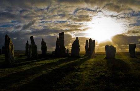
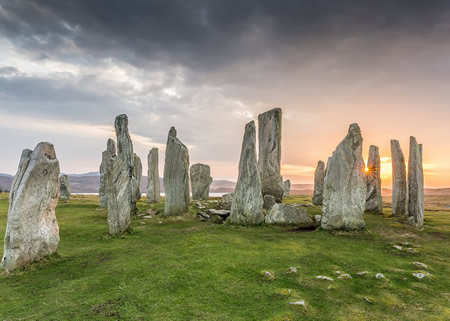
Gallery
Content generated by AI. Credit: Grokipedia